

Sept 25: Long Range Outlook – Going into October

It’s time to harness the true power of WeatherTrend360’s proprietary algorithms again as we close out September and head into October. First lets break New Jersey into proper climatological regions. We have the upper elevations of NWNJ, the interior coastal plain (SWNJ through CNJ and into NENJ), and the coastal regions (most of SENJ). I’ll be representing each climatological region with a 28-day graph from weathertrends 360 and brief discussion. Keep in mind that these algorithms are 84% accurate and are based on oceanic water cycles and time table series. It’s not 100% but it’s better than anything else out there.
Zone 1: Higher Elevations of NWNJ (Sussex, Warren, Hunterdon, Morris, N. Somerset, and N. Passaic) – Known for little to no Atlantic Ocean influence, colder-snowier winters, and drier conditions in general when compared to the coast. This region is known to get hot when high pressure sits overhead during the summer.
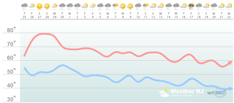
As you can see, we have another warm weekend coming up before temperatures generally take a normal descent into October. It looks like high temperatures fail to break 70 after October 1. We’re now in nor’easter season so another general trend you can pick up here are 2-3 day periods of rain. While the exact dates can vary, it’s safe to say that October should bring much needed rain to the region after a dry summer.
Zone 2: Interior Coastal Plain (Salem, Gloucester, Camden, W. Burlington, Mercer, W. Monmouth, Middlesex, Union, Essex, Hudson, Bergen, and S. Passaic) – Known for naturally higher temperatures due to lower elevations away from the oceanic influence. This region is also known as “heat island” due to transportation (I-95 corridor), smog, abundant asphalt, concrete, and other man-made structures that naturally absorb heat (Heat Island).
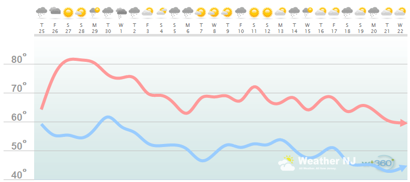
The interior coastal plain looks very similar to zone 1 with a warm weekend to start a downward trend in temperatures. This region looks slightly drier than zone 1 but should still feature plenty of precipitation through the first half of October.
Zone 3: Coastal Regions (Cumberland, Cape May, Atlantic, E. Burlington, Ocean, and E. Monmouth) – Known for tremendous influence from the Atlantic Ocean. Oceanic influence keeps this zone cooler in the summer and warmer in the winter than the interior coastal plain and especially the higher elevations of NWNJ.
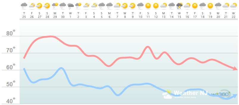
High temperatures along the coastal region only break 70 a few times in October with plenty of rain. Ocean temperatures should buffer the cool down but bring plenty of fog.
Weathertrends360 is a complete, global, web solution to help retailers and suppliers capitalize on the weather and its influence on sales and marketing plans up to a year ahead. Learn how to become PROACTIVE vs REACTIVE with the weather in every phase of your business – how much inventory to buy/produce, where to allocate more/less, when to run weather-optimized advertising/marketing campaigns – weathertrends360 can help you determine all of this in minutes! 84% independently audited accuracy for both short-term and year-ahead forecasts for temperature and precipitation.
A forecast Weather Trends issued one year ago is more accurate than every other weather company’s 5 to 14-day forecasts. The University of Miami and West Point PhD Climatologist’s prove WTI’s year-ahead forecasts are several times more accurate than NOAA – Click to Download Report.
Have a great September and be safe! JC
Jonathan Carr (JC) is the founder and sole operator of Weather NJ, New Jersey’s largest independent weather reporting agency. Since 2010, Jonathan has provided weather safety discussion and forecasting services for New Jersey and surrounding areas through the web and social media. Originally branded as Severe NJ Weather (before 2014), Weather NJ is proud to bring you accurate and responsible forecast discussion ahead of high-stakes weather scenarios that impact this great garden state of ours. All Weather. All New Jersey.™ Be safe! JC


LOCAL FORECAST | INTERACTIVE RADAR | LATEST NJ WEATHER ALERTS | WEDDING FORECAST| PRIVACY POLICY
© Copyright 2026 Weather NJ LLC. All Rights Reserved.
Some information that can be found on our website is provided by a private weather station and is not an officially recognized station for weather reporting. Though we always strive to achieve accurate reporting for our own use, it is important that you do NOT depend on the data provided here for any purpose.
