

Sept 4: Dorian NJ Impact Update
Discussion: Per the latest (5PM) National Hurricane Center update Dorian is still packing sustained winds of 110mph and is moving N/NW at 8mph with a central pressure of 961mb.
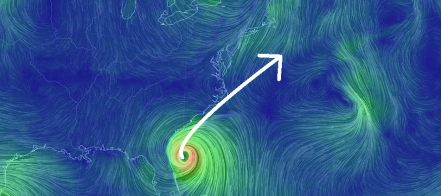
Dorian is just off the coastal Jacksonville, FL/Savannah, GA area. In the past few hours Dorian has looked healthier and there’s no reason for it not to re-intensify back to a major category 3 hurricane overnight. It’s over the gulf stream and is currently strengthening. I doubt rapid intensification will happen but a slow creep until SC/NC land interaction is completely plausible.
Dorian should make the curve first to the N and then to the NE. The eye is going to get pretty darn close coastal SC and NC with a landfall possible. The areas of land that stick out the most into the Atlantic Ocean are Bald Head Island, Cape Lookout and Cape Hatteras. These areas have the best chance for landfall in the Thursday night/Friday morning period but should at least get very close to the highest eye wall winds. It goes without saying that heavy rain, damaging winds and nasty storm surge coastal flooding are likely for the entire GA/SC/NC coast between now and Friday morning.
Friday still looks like the day for Dorian’s far-NW side to brush New Jersey with fringe tropical conditions. The rain is a hard call. Whether only SENJ just gets into some showers or rain makes it further inland into New Jersey is still up for debate. Either way SENJ is still the most-favored to see outer band rainfall. The same goes for winds. I’m still thinking sustained winds of 20-30mph with gusts of 50-60mph possible along the SENJ coast. Other areas of NJ will likely see less winds due to land friction and proximity from Dorian’s center.
Coastal flooding should be held in check near the high-end of minor/low-end of moderate. We will never really see the E/SE winds that parallel the SENJ inlets. Instead winds should rock from E/NE Thursday night to NE Friday to N Saturday. Also we have a half moon phase. So there should be traditional coastal flooding in the places that normally see it. But I doubt we’re looking at any sort of emergency flooding situation.
Surf should be epic. There will be surfers trying to pull a Point Break end scene. I highly advise staying out of the water until Dorian moves well out to sea. Listen to life guards and township officials regarding swimming conditions. Everything should clear out by Saturday morning yielding beautiful conditions (lower temps and dew points).
Dorian should phase with a few shortwaves in the upper-level northern stream. This should mean a downright nasty extra-tropical cyclone for SE Canada.
In English: Thunderstorms were not much to speak of tonight. NYC saw a nice cell but for the most part the action is isolated and weak ahead of the cold front. The cold front is still coming through overnight however. Tomorrow (Thursday) should feel much cooler and dryer with initial Dorian winds arriving later tomorrow night. Friday should be pissy for SENJ but not so bad for the rest of NJ. Expect periods of tropical-feeling rainfall, gusty winds and minor-to-moderate coastal flooding. Basically typical nor’easter conditions that we see a few times per year. Again to be clear only SENJ should expect the higher wind gusts and heaviest rains on Friday for whatever bands make it to the SENJ coast. All rain should be clear by sunrise Saturday morning. Saturday and Sunday conditions then look majestically clear with lower temperatures and dew points. Dorian will scoop all the humidity out of the region for the time being. I’ll have the full weekend outlook posted tomorrow night. Have a great rest of your Wednesday and please be safe! JC
Download the new free Weather NJ mobile app on Apple and/or Android. It’s the easiest way to never miss Weather NJ content. Our premium services go even further above and beyond at the hyper-local level. Looking for industrial-caliber long-range forecasting data that I personally recommend? Check out WeatherTrends360!
Jonathan Carr (JC) is the founder and sole operator of Weather NJ, New Jersey’s largest independent weather reporting agency. Since 2010, Jonathan has provided weather safety discussion and forecasting services for New Jersey and surrounding areas through the web and social media. Originally branded as Severe NJ Weather (before 2014), Weather NJ is proud to bring you accurate and responsible forecast discussion ahead of high-stakes weather scenarios that impact this great garden state of ours. All Weather. All New Jersey.™ Be safe! JC


LOCAL FORECAST | INTERACTIVE RADAR | LATEST NJ WEATHER ALERTS | WEDDING FORECAST| PRIVACY POLICY
© Copyright 2026 Weather NJ LLC. All Rights Reserved.
Some information that can be found on our website is provided by a private weather station and is not an officially recognized station for weather reporting. Though we always strive to achieve accurate reporting for our own use, it is important that you do NOT depend on the data provided here for any purpose.
