

Sept 4: Hermine’s Next Move
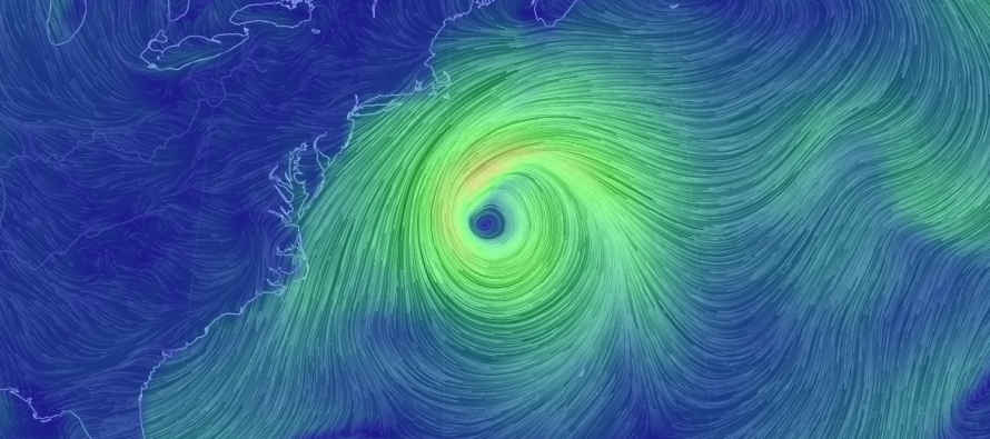
Post-Tropical Cyclone Hermine is still packing sustained winds of 70mph and is coming to a halt on it’s eastward track. It will now stall and retrograde back to the NW before eventually turning back out to the NE. There is still a bit of uncertainty as to how close Hermine will get on it’s westward retrograde but it’s likely that it won’t be close enough to cause the originally expected worst-case scenario. I want that to be clear because I could see panic when Hermine starts heading towards the New Jersey/Long Island area.
At the upper levels, we know that Hermine interacted with the upper-level low too late to be pulled all the way in. Now that Hermine is surrounded by high pressure, it will be pushed out to sea (after the retrograde) by the ridge to its W. The ridge to the E of Hermine should weaken as the W ridge strengthens and that should be the departing mechanism of the system.
This leaves a tremendous amount of uncertainty on the table for how Monday-Tuesday could go for the Jersey coast. It’s the kind of situation where the rain bands could stay just off the coast or possibly just come on to the coast. Also, winds are expected to pick up again but nothing crazy. My best guess are sustained winds of 15-25mph with gusts to 40mph right along the coast (if you were ankle deep in the ocean) and slightly lesser amounts away from the ocean. Basically, we’re subject to the far western fringe impacts of Hermine who is currently 300-350 miles east of the Mid-Atlantic US. I don’t see Hermine getting any closer than 150-200 miles from New Jersey at it’s peak retrograde NE movement.
As far as coastal flooding goes, minor-to-moderate levels of tide water are still expected for the SENJ coast over the next few tidal cycles. Some flooding is expected for shore points N of that but the SENJ coast (beaches, inlets, back bays, lagoons and creeks) should see the most of it.
Wildcards: 1) The storm comes a little further W towards NJ. In that case then rain, wind and coastal flooding would be bumped up some but still not to historic proportions. 2) The storm doesn’t retrograde as much and continues to float away to the E/NE or NE. In that case then the rain would likely never hit the coast, the wind would be less breezy and the coastal flooding would be minor. With those two outer-bookend solutions representing the final spread of uncertainty, I’m leaning towards a solution right in the middle with a stall, retrograde and departure out to the NE.
In English: There’s a small chance of light rain tomorrow along the immediate coast. Expect light-to-moderate winds out of the N/NE or NE (depending on exact position of storm). Minor-to-moderate coastal flooding is possible for coastal Ocean, Atlantic and Cape May Counties due to prolonged wind flow of the slowly moving system. Areas away from the immediate coast should see the nicest conditions. I’ll have an outlook posted tomorrow for the rest of the week. Everyone have a great Labor Day and be safe! JC
Jonathan Carr (JC) is the founder and sole operator of Weather NJ, New Jersey’s largest independent weather reporting agency. Since 2010, Jonathan has provided weather safety discussion and forecasting services for New Jersey and surrounding areas through the web and social media. Originally branded as Severe NJ Weather (before 2014), Weather NJ is proud to bring you accurate and responsible forecast discussion ahead of high-stakes weather scenarios that impact this great garden state of ours. All Weather. All New Jersey.™ Be safe! JC


LOCAL FORECAST | INTERACTIVE RADAR | LATEST NJ WEATHER ALERTS | WEDDING FORECAST| PRIVACY POLICY
© Copyright 2026 Weather NJ LLC. All Rights Reserved.
Some information that can be found on our website is provided by a private weather station and is not an officially recognized station for weather reporting. Though we always strive to achieve accurate reporting for our own use, it is important that you do NOT depend on the data provided here for any purpose.
