

Sept 5: Dorian Effects Approaching
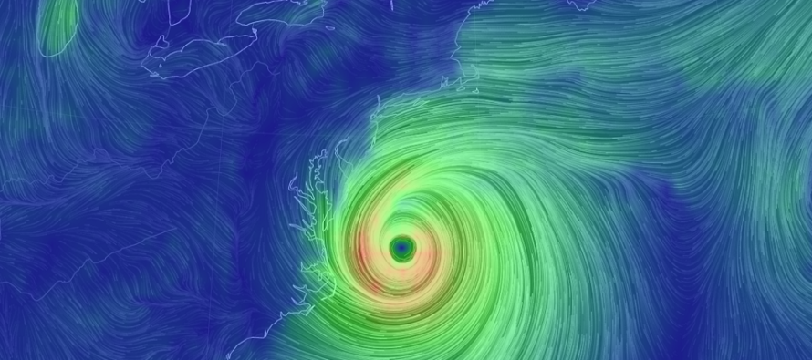
Discussion: The above image represents where Hurricane Dorian should be around 4pm Friday. Hurricane Dorian will not make landfall, or come anywhere near making landfall, on New Jersey. The far-NW side of Dorian’s cyclonic flow however is expected to bring fringe impacts to the SENJ coast tomorrow (Friday). Before we talk about the approaching NJ conditions let’s talk about Dorian’s current state and location.
Per the latest (2PM) National Hurricane Center update Dorian is still packing sustained winds of 110mph and is moving N/NE at 6mph with a central pressure of 958mb. Dorian has been over a favorable environment for sustainment/development mostly credited to the warmer Gulf Stream waters. Today Dorian played chicken with the Myrtle Beach, SC area but made the turn to the N/NE just in time. Now Dorian should track from just off Myrtle Beach towards OBX. This gives coastal locations like Bald Head island, Cape Lookout and Cape Hatteras the best chance to encounter the destructive eye wall winds surrounding the eye. The entire coast from Myrtle Beach to OBX however should expect at least tropical storm force winds and very likely hurricane force winds. Dorian should make this trip between now and tomorrow morning.
Most New Jersey effects should be felt while Dorian then tracks from OBX to just SE of the 40N/70W benchmark. This period should fall between tomorrow morning and tomorrow night. You’re already seeing clouds today associated with Dorian’s far-N side of flow. A cold front came through last night which was reinforced by high pressure. The high pressure is pulling away to the E but still kicking onshore flow backwards into NJ (to the N of the pushed frontal boundary). As the high gets further away it will “pass the baton” of onshore flow to the N side of Dorian as the boundary vanishes. Therefore although the peak effects from Dorian are expected tomorrow for New Jersey expect winds to gradually pick up tonight.
Tomorrow (Friday) is when I expect the following conditions to impact New Jersey:
Rain: Rain is a hard call as far as how far it extends N and W into the upper-level parade of shortwaves rounding the NE US/SE Canadian trough. The cold air associated with the upper-level low pressure will naturally shrink and lower pressure which can lead to additional lifting. If this occurs then rain could reach all the way into New Jersey. Should there be subsidence on the NW side of Dorian then precipitation might be limited to immediate SENJ only. We’re just going to have to nowcast the extent of Dorian’s outer rain bands. For the places that see the most rain (inside the outer bands) up to a few inches are possible. Otherwise rain values should verify lower.
Wind: I have no doubt the immediate SENJ coast is on the hook for gusty conditions. I’m thinking sustained winds of 20-40mph with gusts of 50-60mph. Basically typical nor’easter conditions. Folks…we’re going to have a sub-970mb storm out there. It’s going to crank the winds for the coast. Areas away from the immediate SENJ coast should see lesser wind values due to proximity from Dorian’s center and land friction. Many inland will ask “what winds?” while the coast is roughed up. Areas further up the Jersey coast (Monmouth/N Ocean) should see slightly less intense conditions as well.
Coastal Flooding: As I mentioned yesterday New Jersey will never see a prolonged E/SE or E wind component. Winds should start out of the E/NE tonight and rock to the NE then N by Friday night. Therefore the winds never align with most SENJ inlets which will help mitigate coastal flooding. Also we are between a new and full moon (half phase) which is helpful for astronomical tide. Therefore I am prepared to say that minor-to-moderate coastal flooding is possible but not severe.
Surf: The entire jersey coast should expect dangerous surf. Large choppy waves, fatal rip currents and lots of blowing spray/sand are all expected. I know surfers are going to try and claim their paradise but they know the risk they are taking. Otherwise just stay out of the water until Dorian is gone!
Again all of the above conditions should occur between tonight (Thursday night) and early Saturday morning with the meat and potatoes occurring between Friday morning and Friday night.
In English: Dorian will soon be passing by the Jersey coast a few hundred miles away. That’s not far enough for at least SENJ to escape typical nor’easter conditions on Friday (tomorrow). Please see the above discussion for detailed intensity of each hazard type. Conditions ramp up tonight and clear out by early Saturday morning. Saturday and Sunday still look amazing with lower dew points (humidity) and comfortable temperatures. The full weekend outlook is coming later tonight. Have a great day and please be safe! JC
Download the new free Weather NJ mobile app on Apple and/or Android. It’s the easiest way to never miss Weather NJ content. Our premium services go even further above and beyond at the hyper-local level. Looking for industrial-caliber long-range forecasting data that I personally recommend? Check out WeatherTrends360!
Jonathan Carr (JC) is the founder and sole operator of Weather NJ, New Jersey’s largest independent weather reporting agency. Since 2010, Jonathan has provided weather safety discussion and forecasting services for New Jersey and surrounding areas through the web and social media. Originally branded as Severe NJ Weather (before 2014), Weather NJ is proud to bring you accurate and responsible forecast discussion ahead of high-stakes weather scenarios that impact this great garden state of ours. All Weather. All New Jersey.™ Be safe! JC


LOCAL FORECAST | INTERACTIVE RADAR | LATEST NJ WEATHER ALERTS | WEDDING FORECAST| PRIVACY POLICY
© Copyright 2026 Weather NJ LLC. All Rights Reserved.
Some information that can be found on our website is provided by a private weather station and is not an officially recognized station for weather reporting. Though we always strive to achieve accurate reporting for our own use, it is important that you do NOT depend on the data provided here for any purpose.
