

Sept 5: Watching Florence
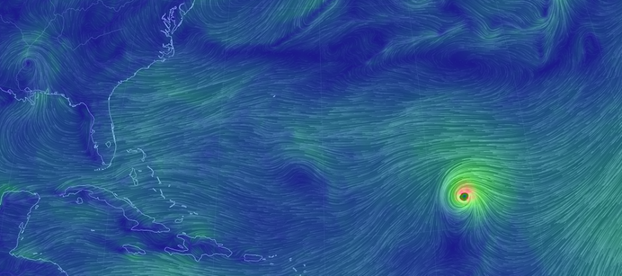
Discussion: Major Hurricane Florence is currently located at 23N 47W. It’s packing sustained winds of 130mph and is tracking towards the general Bermuda region.
Florence’s first hurdle, when we last discussed, were cooler sea surface temperatures W/SW of the Cape Verde Region. It has obviously made it over that hurdle given the current major hurricane status. Now Florence is dealing with the second hurdle, wind shear. There’s a strong SE 250mb jet over Hispaniola and Puerto Rico which will try to take a toll on Florence between now and ~Friday/Saturday. We can assume Florence will make it through this given its current strength.
What this is really going to come down to are the upper level features in the NW Atlantic and their timing, specifically between Saturday and Tuesday. Florence has one escape path out to sea. The current ridge over us will first move east and likely keep Florence on its path to ~Bermuda. A current shortwave in central Canada is then expected to drop into the N Atlantic as a trough behind the current ridge. This trough is a critical opportunity to lift Florence up and re-curve it back to the E (away from the US). If there is not enough interaction and Florence misses the trough connection then east coast impact becomes very probable. Florence will then get caught under another ridge moving in behind the trough. The estimated impact window would be next ~Thursday-Saturday if such were to occur.
It is still too soon to accurately predict what kind of east coast landfall that would be (if the trough connection is missed). The latest model guidance is indicating the general OBX-Delmarva-NJ area but we still have a LONG way to go. Expect more modeled hits and misses before the computers start to get a handle on the trough connection (Hopefully by Saturday morning).
The meteorological principals and players are there though: Warm water, humid air mass, a major hurricane, a trough escape opportunity and the worst case “caught under the ridge” scenario. With that said, let’s give it until Saturday morning to start seriously investing in hurricane plan activation. Until then, I’ll be posting nightly articles and or videos.
In English: Let’s all take a deep breath. I know you’re seeing models of major hurricanes slamming into the Mid-Atlantic US coast but we need to keep a level head. We are still over a week away from any impact. That’s a lot of time for the random chaotic nature, that is the atmosphere, to change the physics ingested by the models. As of right now though, impacts from a hurricane next ~Thursday-Saturday are a real possibility. A hit is not guaranteed nor is a miss out to sea. I will be able to make a much better determination by Saturday morning on the former vs latter. I’ll check in with a nightly article and or video until then covering any developments worth mentioning. At this stage in the game you should all have a hurricane plan, especially if you live in a tidal flooding zone. Saturday would likely be the day to begin activating that plan if current model guidance holds with live atmospheric observations. Until then I am going to try my best to find every scientific reason why this storm could miss and hope that such occurs. If we get hit, I’ll be with you all the way. For those who have followed all through the years, thank you for your amazing support. For everyone new, welcome to Weather NJ. Be safe! JC
Jonathan Carr (JC) is the founder and sole operator of Weather NJ, New Jersey’s largest independent weather reporting agency. Since 2010, Jonathan has provided weather safety discussion and forecasting services for New Jersey and surrounding areas through the web and social media. Originally branded as Severe NJ Weather (before 2014), Weather NJ is proud to bring you accurate and responsible forecast discussion ahead of high-stakes weather scenarios that impact this great garden state of ours. All Weather. All New Jersey.™ Be safe! JC


LOCAL FORECAST | INTERACTIVE RADAR | LATEST NJ WEATHER ALERTS | WEDDING FORECAST| PRIVACY POLICY
© Copyright 2026 Weather NJ LLC. All Rights Reserved.
Some information that can be found on our website is provided by a private weather station and is not an officially recognized station for weather reporting. Though we always strive to achieve accurate reporting for our own use, it is important that you do NOT depend on the data provided here for any purpose.
