

Sept 6: Dorian Departs. Now what?
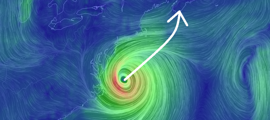
Discussion: Hurricane Dorian made landfall at Cape Hatteras, NC early this morning. There is some debate as to whether it was technically a landfall since the exact center of the eye might have missed land. But since Cape Hatteras went inside at least the NW part of Dorian’s eye that’s probably close enough to a landfall regarding safety hazards. Dorian effects for New Jersey have likely peaked. Rainfall was held mostly to SENJ this morning and then near I-95/NJTP throughout the day. A few downpours here and there and a lot of drizzle but not a widespread drench. Winds were about what I expected. Brigantine saw a gust of 55mph and Atlantic City a gust of 50mph. Lots of 40mph+ up and down the coast. Lesser winds inland dur to land friction. Coastal flooding was held to minor levels for this afternoon’s high tide. The next tide of interest is during early Saturday AM hours but winds should be northerly by then which should continue to mitigate any serious flooding problems. The Surf will remain rough through the weekend so please use common sense regarding swimming safety. Mind the flags and listen to the life guards. Dorian will continue to pull away and we will now enjoy gorgeous conditions for the rest of the weekend. Nova Scotia and other E Canadian locations however should expect a powerful maritime extra-tropical cyclone hit which will have zero effect on New Jersey. If all you wanted was a Dorian recap I suggest you stop reading now.
The next part of this article is a very long-range discussion about what could happen down the road. It couldn’t be any further from an actual forecast (what I think will happen in the near future). You’ve been warned…
So what now? It’s peak hurricane season. While we were focused on Dorian storms E-G formed. Tropical Storm Erin formed between the US and Bermuda last week and never made it to hurricane status. Tropical Storm Fernand formed in the Gulf of Mexico and made landfall on the E gulf coast of Mexico. Tropical Storm Gabrielle is currently in the middle of the Atlantic Ocean smacking up some fish. This brings us to the next letter H which will be Humberto.
Invest 94L is just departing the Cape Verde region of Africa. Right now it is still just a tropical wave but I’m starting to see some circulation so it will likely be upgraded to Tropical Depression 9 in the near future. These waves form from intense heat rising from the surface of Africa. This lifting tends to consolidate into areas of lift and only drift westward due to Earth’s rotation. Once out over the ocean the areas of lift must fill the void beneath the lifting. As the surface air rushes together underneath the Coriolis effect creates the initial slight spin of the tropical cyclone. Latent heat is released from the ocean surface into the storm via evaporation. Thunderstorms form which contribute the additional lift needed to intensify the tropical cyclone. At this point the westward motion is supported by the natural trade winds rather than slipping west due to Earth’s rotation. And that’s where we are at now with Invest 94L.
Invest 94L is expected to track west over the next week or so before even approaching the E Caribbean (around September 15). By then it might be either Tropical Depression 9 or named Humberto depending on its development. I’m not going to do daily updates on this. After this article it will be at least a few days before we check back in on Invest 94L’s status. So why am I looking at this storm so far away? Long-range pattern analysis indicates ridging over the E US in the Sept 18-22 period. Troughs are what either kick tropical storm systems out to sea or capture them for sudden westward turns (like Sandy). Ridges however allow tropical cyclones to move right underneath in a broad slow curve. It was a trough that turned Dorian from W to N and ultimately NE. Without that trough…if there was a ridge in-place instead…Dorian would have slammed dead into the E US coast somewhere (probably Florida). Strong ridging over the E US in the Sept 18-22 period also means a perfectly placed anti-cyclone over Bermuda (the Bermuda high)…another tropical steering mechanism that could pick Invest 94L up and steer it towards the E US coast.
I know this seems like a long shot or a fantasy forecast but again I just want to express what I am thinking for later in September…and only for those who care for it at this time. It is my highest hope that Invest 94L fizzles out or re-curves into a fish storm. I don’t wish for tropical impact under any circumstances and neither should you. Today’s technology however allows us to learn a lot through intelligent and responsible discussion.
In English: Dorian is pulling away. Winds will shift to the N and subside some (not totally) and skies will clear for a beautiful dry weekend. Many of you have asked if there are any more tropical systems on the horizon. If you care to know what’s possible then please see the above discussion about a long-term scenario that could eventually threaten the E US coast. We are SO far from this being any kind of forecast of confidence. You asked? These are my thoughts. You’re likely going to hear about it elsewhere anyway, likely in a sensationalized form, so at least you know where to come for a responsible take on the setup. Updates on this system will not be daily but rather every dew days so long as it keeps moving west across the Atlantic Ocean. Otherwise please enjoy the beautiful September weather that starts tonight. Be safe! JC
Download the new free Weather NJ mobile app on Apple and/or Android. It’s the easiest way to never miss Weather NJ content. Our premium services go even further above and beyond at the hyper-local level. Looking for industrial-caliber long-range forecasting data that I personally recommend? Check out WeatherTrends360!
Jonathan Carr (JC) is the founder and sole operator of Weather NJ, New Jersey’s largest independent weather reporting agency. Since 2010, Jonathan has provided weather safety discussion and forecasting services for New Jersey and surrounding areas through the web and social media. Originally branded as Severe NJ Weather (before 2014), Weather NJ is proud to bring you accurate and responsible forecast discussion ahead of high-stakes weather scenarios that impact this great garden state of ours. All Weather. All New Jersey.™ Be safe! JC


LOCAL FORECAST | INTERACTIVE RADAR | LATEST NJ WEATHER ALERTS | WEDDING FORECAST| PRIVACY POLICY
© Copyright 2025 Weather NJ LLC. All Rights Reserved.
Some information that can be found on our website is provided by a private weather station and is not an officially recognized station for weather reporting. Though we always strive to achieve accurate reporting for our own use, it is important that you do NOT depend on the data provided here for any purpose.
