

Sept 9: Irma to Strike Keys and Western Florida
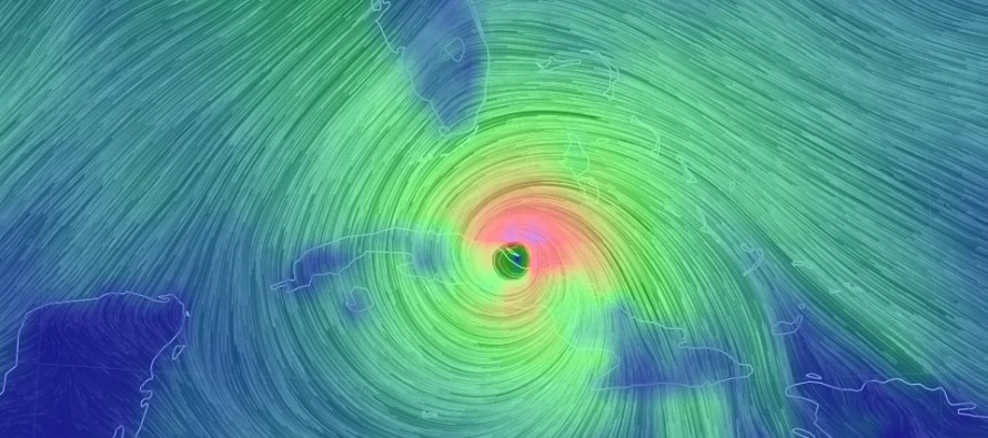
Discussion: Major Hurricane Irma has been forced further to the south and west before making the turn north towards Florida. This should ensure that Irma’s eye moves up the W Florida coast instead of straight up the middle of Florida or up the E Florida coast. The reason for this delay in the turn northward is because the Atlantic ridge maintained a little more strength before retreating and breaking down. Also, Irma has weakened back into a category 4 major hurricane after Cuba interaction however she is still extremely destructive and could easily restrengthen before hitting S Florida. Here’s the latest update by the National Hurricane Center:
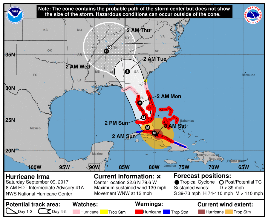
For almost a week now, cities like Miami, Fort Lauderdale and West Palm Beach were expecting a potential landfall. The Georgia and South Carolina coasts were expecting the same after Irma potentially staying just off the E coast of Florida. The European model picked up on the W trend two days ago but was considered the furthest W track possible. Overnight, that track has become a reality. Therefore, the Miami area and most of the E Florida coast should see far-less destructive conditions, having been spared of the eye wall winds. The worst of it now aimed at all of the Keys first followed by the Marco Island/Naples region up through Tampa. This is extremely unfortunate as many in E Florida have evacuated but many in W Florida have not.
We have to allow the possibility for Irma to re-strengthen when passing over the extremely warm waters between Cuba and the Keys. There is minimal shear and therefore she could flex again just before reaching the Keys. MAKE NO MISTAKE, much of Florida should feel hurricane-force impacts, especially those S of the I-75 highway. I don’t expect Irma to weaken below destructive criteria until it reaches the Orlando latitude…where it might be more eastward over land (west-central FL). But again, the SW Florida coast (Keys to Tampa) will likely see the worst of it later today into tomorrow morning. New Jersey should now expect a nuisance-at-most period of rain and breeze Tuesday into Wednesday morning and it might not be much of anything at all.
Jose will likely just scrape the N Lesser Antilles between today and tomorrow. After that Jose should meander S of Bermuda (off the SE US coast) before the upper-level pattern irons itself out for ultimate Jose steering effects. For now it will not impact the east coast however should it make a crazy roller coaster-like loop, it could come back to the W later next week. We have some time with Jose but for now, no immediate east coast threat exists from Jose.
In English: First and foremost, New Jersey is safe from any level of damaging impact from Irma. Her remnants are expected to move through NJ between Tuesday and Wednesday morning but they are now looking like even less of a big deal…far from destructive and likely not much at all. Irma is now expected to hit the Keys later this evening followed by the Naples-Fort Myers-Tampa coastal area overnight and through tomorrow. It is not too late to get out of that stretch so please consider it if you haven’t yet! All of Florida (S of the Orlando latitude) are likely on the hook for at least hurricane-force wind gusts and heavy rainfall. The worst of the storm surge should still occur from as far north as Miami on the east side down and around the Keys (worst surge area) and around to the SW coast of Florida (worst wind area). Once Irma gets to the Orlando latitude she should weaken substantially before heading towards Georgia. Both Georgia and South Carolina can relax some as only tropical storm-force conditions are expected wind-wise. Rainfall however could still be significant well into the SE US. Rainfall will not be like Harvey in Houston since the storm will be steadily moving northward (unlike the stationary movement of Harvey).
New Jersey will be fortunately spared from this catastrophic event. This became apparent to me days ago and was even further re-enforced by the trends over the last few days. Our deepest thoughts and concerns are with those just affected and those in the immediate path of Irma (Keys and SW Florida). Please be safe! JC
Jonathan Carr (JC) is the founder and sole operator of Weather NJ, New Jersey’s largest independent weather reporting agency. Since 2010, Jonathan has provided weather safety discussion and forecasting services for New Jersey and surrounding areas through the web and social media. Originally branded as Severe NJ Weather (before 2014), Weather NJ is proud to bring you accurate and responsible forecast discussion ahead of high-stakes weather scenarios that impact this great garden state of ours. All Weather. All New Jersey.™ Be safe! JC


LOCAL FORECAST | INTERACTIVE RADAR | LATEST NJ WEATHER ALERTS | WEDDING FORECAST| PRIVACY POLICY
© Copyright 2026 Weather NJ LLC. All Rights Reserved.
Some information that can be found on our website is provided by a private weather station and is not an officially recognized station for weather reporting. Though we always strive to achieve accurate reporting for our own use, it is important that you do NOT depend on the data provided here for any purpose.
