

September Ends Warm and Humid
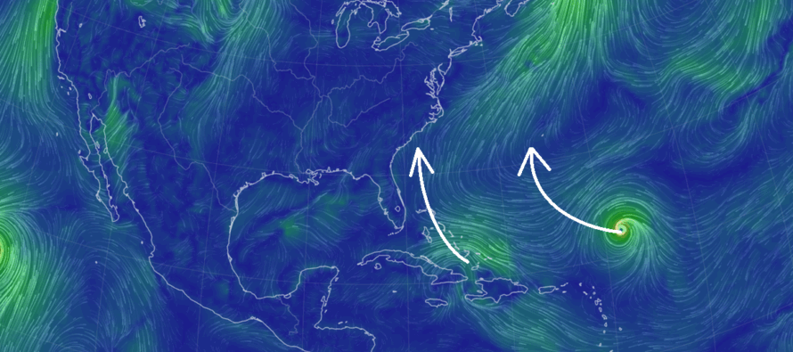
Discussion: A cold front pushed through early this morning. Unfortunately, it only reduced temps and humidity a little rather than a lot. We should stay dry for the rest of Friday evening and overnight through much of Saturday. A weak disturbance should then bring some additional rainfall through NJ between Saturday night and Sunday morning. The timing, as of right now, appears optimal in the sense of rain holding off until it’s dark Saturday night and ending before the sun is back up Sunday. So daytime hours on Saturday and Sunday look much better (despite being a little warmer and more humid than you’d like to see) than the overnight hours do Saturday night into Sunday morning. Monday and Tuesday are very uncertain with both tropical systems (Humberto and Imelda) on our side of the Atlantic. Their influence will radically shape the overall pattern for NJ and much of the E US coast. First, we have a very strong ridge in SE Canada expected to move in next week which correlates with a strong and broad area of high pressure throwing steering flow southward towards NJ. This should prevent Imelda’s core circulation remnants from making it any further N than about North Carolina. Northern rain bands from Imelda’s remnants, however, could push into at least SNJ in the Mon-Tues period if they aren’t squashed south completely by the high pressure denial. This is very uncertain and will have to be called on Sunday closer to the outcome. Humberto is then expected to either pass either just W or over the Bermuda area Tues-Wed, sending enhanced surf into the E US/NJ coast next week. Expect large waves and rip current hazards (surfer’s paradise?). But after that, the high pressure/ridge will win out and deliver the coldest and driest air of the season from Wed Oct 1-forward. We’re talking about highs stuck in the 60s and overnight lows down well into the 40s. We’ve had a few whiffs of fall feelz in September, but this should be a solid fall bite and rightfully so on the calendar. The departure of the tropical systems in combination with the high pressure will be the culprit for ripping the Canadian air downwards over NJ from Wednesday, Oct 1 and forward. From now through Tuesday, expect warm and humid conditions to close out the month.
Forecast
Friday (Sept 26) high temperatures are maxing near-80 for many locations with slightly less humidity (but still humid). Skies should remain improved for the rest of this evening/overnight. Winds are now light out of the NW. Overnight lows should range from 50-65 from NNJ elevations to SNJ coasts with most of NJ bottoming out in the 55-60 range.
Saturday (Sept 27) high temperatures should reach the mid-to-upper 70s for most NJ locations. Skies should cooperate with daytime hours as mostly clear skies in the morning transition to mostly cloudy by late-afternoon. Rain should hold off until 5pm possibly later and fall mostly overnight. Winds should be light out of the E/NE. Overnight lows should fall to the 60-65 range as rain pushes through, ending by 8am Sunday, possibly earlier.
Sunday (Sept 28) high temperatures should reach the 80-85 range for most NJ locations. Coastal areas should stay in the 75-80 range. After rain tapers off by mid-to-late morning, skies should become mixed with sun and clouds with a humid feel. Winds should be light-to-breezy out of the NE. Overnight lows should range from 55-65 from NNJ elevations to SNJ coasts.
An early look at next week (Sept 29-Oct 3) indicates more of the same (warm, humid and unsettled – rain at times possible for SNJ) for Monday-Tuesday to close September out. This should be from rubbing elbows with the N side of Imelda’s precipitation shield once it weakens over the SE US. Then starting Wednesday (Oct 1), we should see the most radical change towards fall that we’ve seen yet. I’m seeing highs stuck in the 60s and lows well down into the 40s. Everyone have a great weekend and please be safe! JC
Premium Services
KABOOM Club offers ad-free content, inside info forecast discussion, your questions answered, and early storm impact maps and video releases (ahead of the public). At two bucks per month, it’s an extremely feasible way to show additional support for Weather NJ. Think of it as a tip jar with perks. Available onFacebook or Patreon.
My Pocket Meteorologist (MPM), in partnership with EPAWA Weather Consulting, offers professional/commercial interests, whose businesses depend on outdoor weather conditions (snow plowing, landscaping, construction, etc.), with hyper-local text message alerts/forecasts and access to the MPM premium forum—the most comprehensive and technical forecast discussion available for PA and NJ.
Jonathan Carr (JC) is the founder and sole operator of Weather NJ, New Jersey’s largest independent weather reporting agency. Since 2010, Jonathan has provided weather safety discussion and forecasting services for New Jersey and surrounding areas through the web and social media. Originally branded as Severe NJ Weather (before 2014), Weather NJ is proud to bring you accurate and responsible forecast discussion ahead of high-stakes weather scenarios that impact this great garden state of ours. All Weather. All New Jersey.™ Be safe! JC


LOCAL FORECAST | INTERACTIVE RADAR | LATEST NJ WEATHER ALERTS | WEDDING FORECAST| PRIVACY POLICY
© Copyright 2025 Weather NJ LLC. All Rights Reserved.
Some information that can be found on our website is provided by a private weather station and is not an officially recognized station for weather reporting. Though we always strive to achieve accurate reporting for our own use, it is important that you do NOT depend on the data provided here for any purpose.
