

September Heat Rages. Tropics Awake.
Discussion: We should have SW flow in the mid-upper levels this week. This should sustain the warmer airmass through at least Thursday, possibly Friday despite the W/NW or even NW flow at the lower-levels. The source of the lower-level flow is still very warm which will explain why we don’t have a typical cooler and drier feel with NW winds. This means 90s, possibly 100 (records could be broken) Wednesday and Thursday. Dew points however do not look horrible. They should be in the 65-70 range this week which will still make it feel even hotter…but much better than if dews were in the 70-75 range. The slightly lower dews will actually allow the air temp to break into the 90s easier. I will still issue the caution for today through Friday: Please stay as hydrated and cool as your situation allows for if outside (I will say this for every day through Thursday). Don’t get me wrong, it’s going to be hot! Just not as sweltering as it would feel with the oppressive humidity we’ve had lately. The NW winds will help with humidity but not so much with temps. The next chance for any sort of significant rainfall is late Thursday night/Friday morning and that even looks light. We should then be dry for a few more days before the next chance after that (Sunday night into next week). It looks like an area of convergence could stall a boundary (linear area of lifting) over NJ in that time frame which would mean unsettled conditions. Then we lead into a more significant period of interest, that is the future of Tropical Depression 13…
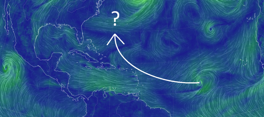
Tropical Depression 13 is currently developing about 1000 miles directly E of the Lesser Antilles. Most long-term hurricane guidance turns TD13 towards the US east coast after just missing the NE Caribbean this weekend. From there, the guidance recurves TD 13 back away from the US without hitting the US east coast. However, it does pass inside of Bermuda. It’s way too early to think landfall or complete miss. We will have to monitor such especially through this weekend. I expect changes in track especially as a lot of the steering currents involve upper-level trough reliance in specific ways. Some of the ensemble guidance has a few outliers into E Long Island/Coastal New England with the majority of the spread curving before hitting the east coast. The guidance suggests this will be passing NJ latitude around Thursday Sept 14. Whether it will be close to NJ longitude or far from is what is yet TBD. But as modeled verbatim for now, it is more of a Bermuda threat than an east coast threat for primary impact. The east coast would only see secondary impacts (surf, rip currents, etc.) if today’s modeled solution were to play out. Obviously stronger secondary impacts if a NE US direct impact. Should have a better idea by Friday assuming the ensemble spread tightens some more with the curve out-to-sea solution. Once TD13 meets the criteria of a Tropical Storm, it will likely be named Lee.
Tuesday (Sept 5) high temperatures are currently (as of 2pm Tuesday) in the lower-80s for higher NNJ elevations and immediate ECNJ/SENJ coastal regions. Mostly everyone else has reached 90 and we still have an hour or two to warm a few more degrees. Dew point temps are 70+ for pretty much everyone which correlates with the sticky feel. Stay as hydrated and cool as your situation allows for if outside. Winds are light out of the W/NW and overnight temps should bottom out in the 65-72 range from NNJ elevations to SNJ coasts. The NWS has a rip current statement valid until 9PM this evening for surf interests. Please use caution if swimming!
Wednesday (Sept 6) high temperatures should reach/break 90 for most of New Jersey even the coasts. Wouldn’t be surprised to see temps flirt with 100 by early afternoon in the typical warmer locations of interior CNJ/SNJ. It looks like record highs are possible for this date (9/6/2023). Skies should be mostly sunny with a humid feel. Stay as hydrated and cool as your situation allows for if outside. Winds should remain light out of the W/NW. Overnight lows should range from mid-60s to mid-70s from NNJ elevations to SNJ coasts.
Thursday (Sept 7) high temperatures should reach the mid-90s away from the ocean, maybe flirt with 100 again. Stay as hydrated and cool as your situation allows for if outside. Coastal regions should max in the mid-to-upper 80s. Skies should be mixed with sun and clouds with a humid feel. Can’t rule out isolate afternoon/evening showers and thunderstorms. Winds should be light out of the S/SW. Overnight lows should range from mid-60s to mid-70s from NNJ elevations to SNJ coasts.
Friday (Sept 8) high temperatures should range from the mid-80s to lower-90s…80s for NNJ elevations and ECNJ/SENJ coasts…lower-90s for interior CNJ/SNJ/lower altitude NNJ. Skies should be mixed with sun and clouds with a humid feel. Winds should be light out of the S/SE. Overnight lows should range from mid-60s to lower-70s from NNJ elevations to SNJ coasts.
An early look at the weekend indicates a step-down in temps for Saturday and Sunday (highs only in th low-to-mid 80s) however the humidity could linger through the weekend. A series of fronts between Friday and Sunday should eventually take the temps even further down to start next week (highs in the 70s with lower humidity). Then all eyes will be on the tropics next week regarding possible impact from Tropical Depression 13 (to be named Lee and impacts yet TBD). See discussion above for current thoughts.
Premium Services
KABOOM Club offers inside info forecast discussion, your questions answered, and early storm impact maps (ahead of the public). At a buck per month, it’s an extremely feasible way to show support.
My Pocket Meteorologist (MPM), in partnership with EPAWA Weather Consulting, offers professional/commercial interests, whose businesses depend on outdoor weather conditions (snow plowing, landscaping, construction, etc.), with hyper-local text message alerts/forecasts and access to the MPM premium forum—the most comprehensive and technical forecast discussion available for PA and NJ.
Jonathan Carr (JC) is the founder and sole operator of Weather NJ, New Jersey’s largest independent weather reporting agency. Since 2010, Jonathan has provided weather safety discussion and forecasting services for New Jersey and surrounding areas through the web and social media. Originally branded as Severe NJ Weather (before 2014), Weather NJ is proud to bring you accurate and responsible forecast discussion ahead of high-stakes weather scenarios that impact this great garden state of ours. All Weather. All New Jersey.™ Be safe! JC


LOCAL FORECAST | INTERACTIVE RADAR | LATEST NJ WEATHER ALERTS | WEDDING FORECAST| PRIVACY POLICY
© Copyright 2026 Weather NJ LLC. All Rights Reserved.
Some information that can be found on our website is provided by a private weather station and is not an officially recognized station for weather reporting. Though we always strive to achieve accurate reporting for our own use, it is important that you do NOT depend on the data provided here for any purpose.
