

Severe Storms Possible Tomorrow Morning
Discussion: As soon as you say the word Derecho, everyone loses their mind, especially since the June 2012 Derecho hit the N VA/DC/SNJ area so hard. Let’s get the hype anchored to some facts. In order for a system to be classified as a Derecho, you need a linear severe wind stormfront at least 60 miles wide to travel for at least 240 miles. The June 2012 event was hundreds of miles wide and ran for 600 miles from the Great Lakes to the Mid-Atlantic US coast. A Derecho classification usually stems from a Mesoscale Convective System (MCS). When we have an E US ridge placement like this…
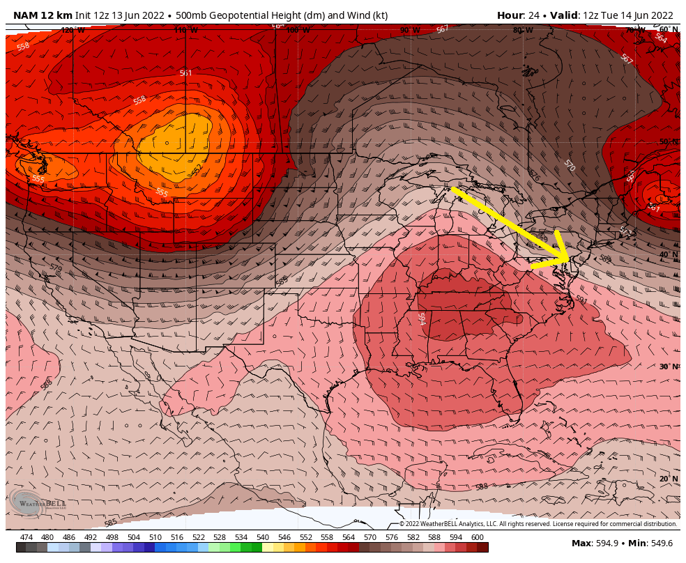
…a very fast people mover (yellow arrow) is created around the top of the ridge for storm energy to travel on. It’s called the ring of fire pattern and it looks like it will produce at least an MCS with a similar track to the June 2012 event. For the crystal clear record, I am not forecasting a Derecho. It could very well happen but I am much more confident in just forecasting an MCS that should track from the lakes to the Mid-Atlantic US. The exact track will be determined by how much influence the trough to the NE has, the axis of the ridge, and a few other upper-level steering influences.
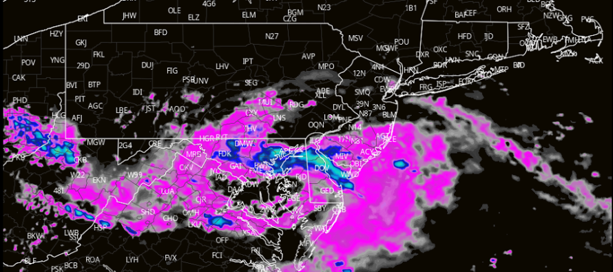
So there is still some uncertainty as to whether this thing will only rock the N VA/DC area or include some of NJ. “Some of NJ” would likely mean WCNJ/SWNJ/SNJ given proximity to DC. With that said, NENJ would have the least chance of severe conditions being the furthest away from DC. Less severe conditions could push further N into NJ though. Here is the most recent high-res NAM frame of the biggest NJ impact. The frame shows precipitation intensity but you can identify by the inward banding a cyclonic nature to the system as a whole…
The strongest Convective Available Potential Energy (CAPE) will be located to the S and W of NJ overnight tonight. That tells me the most severe conditions of this system tomorrow morning will likely hit the N VA/DC area. However areas in WPA/SEPA/SNJ should encounter 1) the lifting mechanism of a nearby meso low 2) the lifting mechanism of an expanding outflow/gustfront ahead of the storms and 3) adequate wind shear to support thunderstorms. Despite lower instability to the NE side of the storm track, the air is dank (dews close to temps) and won’t need much time to fully saturate with said lift.
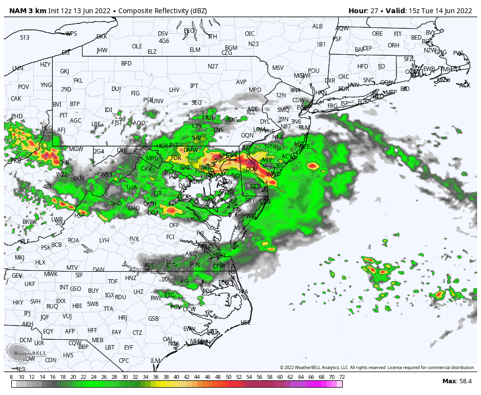
Timing for NJ is somewhere in the 7-11am range. It’s difficult to narrow that from this point considering these things can travel anywhere from 40-70mph depending on their organization. Will need to play the radar. But it should be a cluster of thunderstorms, possibly in a bow echo formation, that should push through from W/NW to E/SE in that general time frame. The extent of how much it spills N into NJ is still yet TBD.
The bottom line is that damaging winds are very likely for the N VA/DC area tomorrow morning and there’s a possibility that some of those winds could make it up into at least SWNJ/SNJ.
In English: Tomorrow morning’s thunderstorm threat varies (from greatest to least) from SWNJ to NENJ. A very strong system of thunderstorms will likely pass through the N VA/DC area tomorrow (Tuesday) morning. This is not something that you want so hopefully the most severe conditions stay to the S/SW of NJ. However there’s a possibility that the northern side of the thunderstorm system could clip SWNJ/SNJ maybe even further N into the state between about 7-11am tomorrow (Tuesday) morning. Since NENJ will be the furthest from the stormiest area, they have the least chance of any activity. Maybe CNJ sees some northern fringe less severe rain/rumbles but I am most concerned about the potential damagine wind threat for SWNJ/SNJ. We’ll probably see this form on radar soon near the Great Lakes. Will definitely be tracking overnight. I’ll check in late-night with some radar obs. In the meantime, SWNJ/SNJ should prepare for a potentially stormy/windy morning. Be safe! JC
Premium Services
KABOOM Club offers inside info forecast discussion, your questions answered, and early storm impact maps (ahead of the public). At a buck per month, it’s an extremely feasible way to show support.
My Pocket Meteorologist (MPM), in partnership with EPAWA Weather Consulting, offers professional/commercial interests, whose businesses depend on outdoor weather conditions (snow plowing, landscaping, construction, etc.), with hyper-local text message alerts/forecasts and access to the MPM premium forum—the most comprehensive and technical forecast discussion available for PA and NJ.
Jonathan Carr (JC) is the founder and sole operator of Weather NJ, New Jersey’s largest independent weather reporting agency. Since 2010, Jonathan has provided weather safety discussion and forecasting services for New Jersey and surrounding areas through the web and social media. Originally branded as Severe NJ Weather (before 2014), Weather NJ is proud to bring you accurate and responsible forecast discussion ahead of high-stakes weather scenarios that impact this great garden state of ours. All Weather. All New Jersey.™ Be safe! JC


LOCAL FORECAST | INTERACTIVE RADAR | LATEST NJ WEATHER ALERTS | WEDDING FORECAST| PRIVACY POLICY
© Copyright 2026 Weather NJ LLC. All Rights Reserved.
Some information that can be found on our website is provided by a private weather station and is not an officially recognized station for weather reporting. Though we always strive to achieve accurate reporting for our own use, it is important that you do NOT depend on the data provided here for any purpose.
