

Snow Approaching New Jersey
Discussion: We’ve beat this system to death for over a week now as a long-tern storm signal coming into fruition. We discussed the physics of an InVerted Trough (IVT) and what it means for surrounding areas. You can look back at any of the articles for more IVT info. For today, it’s going to be about what to expect and why.
Real quick, let’s talk about this Arctic air we’ve seen for about the last week or so…and to finish through this weekend. When the Sudden Stratospheric Warming Event (SSWE) occurred and split the Polar Vortex (PV) into two lobes, the lobe on our side of the Northern Hemisphere went into the W US, not the E US. It was the W US who recently saw record cold and snow, not the E US. The Arctic air has now moved from W US to E US however it has moderated. Obviously we are not seeing the ridiculous temps like parts of the NW and C US just saw. That was us in Winter 2013-2014 when the PV lobe pushed into E US, not W US. This is not that but still very cold. With that said, the Arctic air we have been seeing is not cold and strong enough to completely remove the mixing aspect for extreme SENJ coasts. Look what happened the other day all the way into I-95. So hopefully this clears some confusion as to why we are just “very cold” and not “completely Hoth in Star Wars” with regard to our colder active pattern. With that caveat and rant out of the way, let’s dive right into the forecast description that accompanies the below snow map:
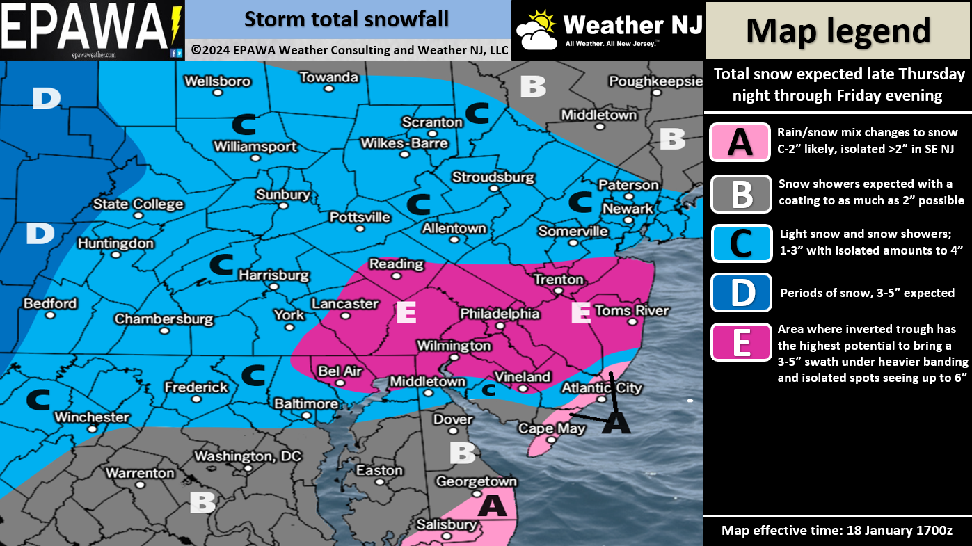
Zone C through NNJ: This area should be on the northern side of the IVT influence. It is therefore subject to drier sinking air (subsidence) that adjacently reciprocates the wetter rising air inside the IVT axis just S of this zone. Much like the minimum region-wide expectation, this area (Zone C through NNJ) should see between 1-3 inches of snowfall with the possibility of isolated locations seeing 4 inches. If there’s going to be a wildcard, the S areas of this zone could perform slightly higher than the expected range should the IVT trough axis drift a bit N between now and tomorrow (completely possible). But we’re confident in at least a 1-3” iso 4” situation here.
Zone E through CNJ/SNJ: This is where we believe the IVT will hit the hardest on Friday. Notice a small change in the IVT axis from yesterday’s initial map. It now runs more W to E rather than W/NW to E/SE. This is due to the placement relationship of the primary and secondary lows (one in the ocean and one near the lakes). We made the best adjustments we could given the recent data trends and live observations upstream. This area, at the very minimum, is also by default a 1-3 iso 4 situation if the IVT were to peter out. But with the IVT influence, which we believe there will be at least some, we believe that 2-5” iso 6” can happen here (Zone E). Could it be more? Sure, why not. IVTs are wild. The S areas of this zone are the most uncertain as some mixing could occur and knock down totals a little.
Zone C through SNJ: This area features a high amount of uncertainty. A small shift south with the IVT axis and this area behaves like Zone E. A small shift north/or slightly more mixing and this area behaves like zone A. What we have here is a happy medium, but this zone has high bust potential in either direction. It’s nightmare fuel to forecast a baroclinic layer situation like this with an IVT. It’s possible that this area goes 1-2 degrees above freezing for an hour or two mid-day Friday which could inhibit this zone from seeing the potential that zone E says. For now, a 2-3 outcome is the best evidence-based prediction we can make.
Zone A through SENJ: This area, like Zone C through SNJ, has high bust potential. However, this area is most subject to the warmer Atlantic Ocean influence. Ocean temps are still just above 40F. This system will not get as warm as the last system along the SENJ region. However, a few layers, including the surface/low-mid layers could just rise above 32. At the very least this would inhibit proper dendrite (snowflake) growth or possibly allow some sleet/rain to fall. For this reason, we have this zone in a C-2 iso >2 expectation.
Timing: Timing has moved away from starting late tonight (Thursday night). Some areas today and tonight (before midnight) could see some lighter flurries. The meat and potatoes of the snow should approach WNJ around 2-4am and reach ENJ by 4-6am tomorrow morning (Friday). A steadier snow should then build from 6am to about 9am tomorrow (Friday). Peak snowfall (including IVT influence) would be between about 9am and 6pm – again lighter outside of IVT zone. The period for potential mixing along the SENJ coast would be from about 11am to 3pm tomorrow (Friday). The system should then finally taper off very cold (snow for all) between 6pm and 9pm. Anything after that would be an unforeseen bonus but last flakes would occur by midnight.
Looking Forward: Behind this system will be another very cold pull-down of Arctic air. Saturday night and Sunday night might verify even colder than last night did (I woke up to 13F this morning). We’re then frigid through Monday morning with Saturday and Sunday high temperatures likely staying below 32F. The January thaw then starts Monday (a day of transition) then really gets going for the rest of next week (until about Jan 28-29). Cold air should then push in for the last day or two of January and start a colder February. We currently believe there will be more snow chances in February. Personally, I’m looking forward to taking a small break next week. Although snow totals have not been large, it’s been nonstop butt-kicking since New Year’s Eve: The system that brought a foot to NNJ, two Great Lakes Cutters with wind and flooding, the lighter event the other day that turned into a severe ice hazard and now this event tomorrow. There might be a rain system or two during the Jan 22-28 thaw. I will get into that on Monday with a nice relaxed weekly outlook.
In English: Snow should move into New Jersey early tomorrow (Friday) morning. All of NJ is on the hook for a general 1-3 inches of snowfall with the potential for isolated and localized instances of 4 inches. CNJ and most of SNJ could see 2-5 inches of snow, possibly some areas reaching 6. Extreme SNJ/SENJ areas could see temp issues knock down totals in the form of sleet/rain or maybe just snow falling onto a slightly above-freezing surface. Very high uncertainty with this system and therefore high bust potential. At least there are no coastal or freshwater flooding issues with this one. Ultra short-range model analysis will continue tonight then live observations will begin first thing in the morning. Good luck to all and be safe! JC
Premium Services
KABOOM Club offers inside info forecast discussion, your questions answered, and early storm impact maps (ahead of the public). At a buck per month, it’s an extremely feasible way to show support.
My Pocket Meteorologist (MPM), in partnership with EPAWA Weather Consulting, offers professional/commercial interests, whose businesses depend on outdoor weather conditions (snow plowing, landscaping, construction, etc.), with hyper-local text message alerts/forecasts and access to the MPM premium forum—the most comprehensive and technical forecast discussion available for PA and NJ.
Get your KABOOM Inside Out pajamas and more at the KABOOM shop!
Jonathan Carr (JC) is the founder and sole operator of Weather NJ, New Jersey’s largest independent weather reporting agency. Since 2010, Jonathan has provided weather safety discussion and forecasting services for New Jersey and surrounding areas through the web and social media. Originally branded as Severe NJ Weather (before 2014), Weather NJ is proud to bring you accurate and responsible forecast discussion ahead of high-stakes weather scenarios that impact this great garden state of ours. All Weather. All New Jersey.™ Be safe! JC


LOCAL FORECAST | INTERACTIVE RADAR | LATEST NJ WEATHER ALERTS | WEDDING FORECAST| PRIVACY POLICY
© Copyright 2026 Weather NJ LLC. All Rights Reserved.
Some information that can be found on our website is provided by a private weather station and is not an officially recognized station for weather reporting. Though we always strive to achieve accurate reporting for our own use, it is important that you do NOT depend on the data provided here for any purpose.
