

Snow Approaching NWNJ
Discussion: Precipitation is currently moving in from the W/NW. A snow/rain line is forming somewhere between I-80 and I-78 on the W side of NJ. This should extend over into NENJ but likely NW of I-95/NJTP. Precipitation should fall on-and-off for the rest of today and taper off from W to E between this evening and later tonight.
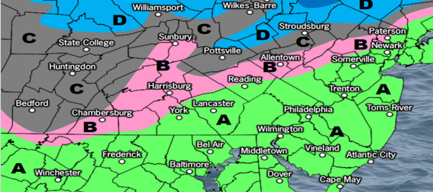
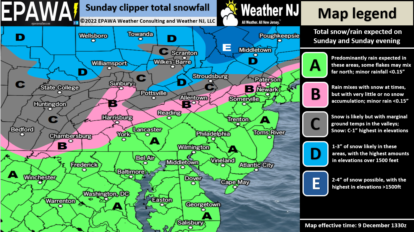
The wintriest aspect (heaviest snow thump) should occur between this afternoon and this evening mainly for NWNJ. Everyone S of I-78 and SE of I-95 should expect mostly all rain with temperatures in upper-30s/40s. Areas between I-80/I-78 and between I-95/I-287 will likely see snow or sleet mix in, even become all snow at times, but struggle to accumulate given the warmer surface profile. Areas N of I-80 and NW of I-287 have the best chance to see accumulating snow this afternoon through evening. There’s only a small chance of precipitation extending past midnight tonight. Most areas should end well before midnight – closer to evening hours. The areas right along 80/287 would probably only be a coating to an inch or two situation and mainly on natural surfaces. The higher elevations of NWNJ would have the best chance at a 2-4” situation. Expect temperatures to dive for all areas from tonight’s sunset and forward. This could change some of the backside precipitation from rain to snow for areas further S but would likely not produce accumulation given the quick departing nature of the system. The below map illustrates our general idea:
The NWNJ snow should end early enough (likely by midnight tonight – maybe early Monday AM) to clear any main travel roads for Monday morning. Monday through Wednesday then looks colder and drier. We’re talking highs maxing near-40 and lows well into the 20s, maybe teens for higher spots (especially spots with snow cover).
Thursday and Friday then look milder and rainy but it’s complicated. The blocking signal will still be alive just to the S of Greenland. Also the W US looks as good as it’s going to look regarding an upstream ridge. I would think this would create a colder trough situation for the E US. Therefore, it’s hard for me to believe the warmer scenario for New Jersey. The Dec 15-17 storm signal has been back and forth the last few days. A few solutions have been really snowy but most are currently leaning warmer for the coastal plain. A low will be crashing into the block near the Great Lakes before transferring to the Mid-Atlantic US low. This presents lots of volatility and will need further analysis this week as the data continues to evolve. But the Dec 15-17 signal is the next period I will be watching for NJ snow after the NWNJ snow today.
Behind the Dec 15-17 system, whatever that becomes, will be a significant shift towards a wintry pattern. It will begin with the cold front from that system. That means Dec 17 into the Christmas period has chances for snow within a prolonged period of colder temperatures settling in. We’re talking highs in the 30s and lows in the teens for most. All thing’s I’ll be watching.
In English: A light snow event is possible for NWNJ this afternoon/evening while the rest of NJ likely remains all rain with above-freezing temperatures. Monday-Wednesday then looks cold and clear for all of New Jersey. I’m watching Thursday-Saturday (Dec 15-17) for another snow/rain situation but it’s very uncertain where the snow/rain line will set up…across NNJ again or further SE to include more of New Jersey in accumulating snow. I will be watching this week and will report accordingly. Have a great rest of your Sunday and please be safe! JC
Premium Services
KABOOM Club offers inside info forecast discussion, your questions answered, and early storm impact maps (ahead of the public). At 99 cents per month, it’s an extremely feasible way to show support.
My Pocket Meteorologist (MPM), in partnership with EPAWA Weather Consulting, offers professional/commercial interests, whose businesses depend on outdoor weather conditions (snow plowing, landscaping, construction, etc.), with hyper-local text message alerts/forecasts and access to the MPM premium forum—the most comprehensive and technical forecast discussion available for PA and NJ.
Jonathan Carr (JC) is the founder and sole operator of Weather NJ, New Jersey’s largest independent weather reporting agency. Since 2010, Jonathan has provided weather safety discussion and forecasting services for New Jersey and surrounding areas through the web and social media. Originally branded as Severe NJ Weather (before 2014), Weather NJ is proud to bring you accurate and responsible forecast discussion ahead of high-stakes weather scenarios that impact this great garden state of ours. All Weather. All New Jersey.™ Be safe! JC


LOCAL FORECAST | INTERACTIVE RADAR | LATEST NJ WEATHER ALERTS | WEDDING FORECAST| PRIVACY POLICY
© Copyright 2025 Weather NJ LLC. All Rights Reserved.
Some information that can be found on our website is provided by a private weather station and is not an officially recognized station for weather reporting. Though we always strive to achieve accurate reporting for our own use, it is important that you do NOT depend on the data provided here for any purpose.
