

Snow Chances Increasing
Discussion: We’re pretty much warm-sectored by the low tracking through the Great Lakes into SE Canada. That low will eventually drag a cold front through NJ Monday night-Tuesday morning. But until then, expect mild conditions. Today’s probably the last sunny day. Tomorrow (Monday) should feel the mildest (just ahead of the front) but will likely be cloudy with periods of light rain possible.
The main batch of frontal rain should then push through NJ Monday night, from W/NW to E/SE, immediately along the cold front. Looks like just rain and breeze. Not concerned with any severe potential. Conditions should then clear behind the cold front (after midnight) as temperatures drop heading into Tuesday sunrise.
Tuesday then looks colder. High temperatures should struggle to escape the 30s and then drop below freezing for most. The last 24 hours of model guidance have trended towards pushing the boundary (behind the departing front) a little further S on Tuesday than yesterday showed. This would make for a colder setup Tuesday and therefore a colder system for NJ on Wednesday. The low would take a track through N OBX latitude rather than Delmarva latitude. Tuesday should have the look/feel/smell of approaching snow, especially overnight into Wednesday.
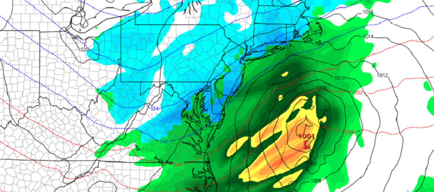
On Wednesday, a low should track just S of NJ out into the Atlantic Ocean before turning N towards Nova Scotia. The low is still modeled relatively weak (~1000mb). But that would be enough to throw some precipitation northward into NJ between about sunrise and sunset on Wednesday. We’ll certainly be cold enough to support snow from 850mb and up. 925mb down to the surface could be tricky. For areas NW of I-95, no problem. NWNJ looks cold enough at all layers to support snow. Areas along 95 and SE might creep above freezing at the surface from late-morning through afternoon hours, especially during any onshore flow components of this system from the ~1000mb low. The ocean is still in the lower-50s this time of year. That would likely cause mixing issues and more of a snow to rain to snow type deal. The 925mb layer can always warm very easily in such a case for SENJ. Heavier precipitation could cool the lower levels and allow more sticking but that’s risky business to expect. But once the low gets E enough, the winds would change colder and we would all end as snow. So I’ll be watching areas along and SE of I-95/NJTP closely for mixing issues, especially SENJ. Not so much an issue NW of I-95. Areas between (from SWNJ up through CNJ into NENJ), you’re in the battle zone of most uncertainty regarding snow/rain lines.
But overall, the models have trended colder for this system in the last 24 hours. This is mainly due to the high pressure pushing the boundary further to the S and E on Tuesday (after the cold front). This allows the low to track further S and for colder air to spill further S above and behind it. The GFS hits NJ pretty good. The Canadian and Euro actually trended too far S. We’re still 72 hours away from this possibility and there is tremendous uncertainty due to the spread in latitude low track potential. If the boundary pushes any further S than modeled today, it could actually start to remove the possibility on the cold side of the spread. I expect more variance overnight tonight but tomorrow it will be time to track seriously and issue an initial snow map. Either way, it looks like the chances of snow for Wednesday are increasing.
In English: Today was dry and relatively milder as expected. Tomorrow (Monday), we’ll see winds increase out of the S/SW with increasing cloud coverage and possibly light rain at times. Monday should be the mildest day of this stretch with temperatures reaching the upper-50s and in some cases lower-60s away from the ocean. Rain is then expected Monday night ahead of a cold front which will drop Tuesday much colder. This will set up a possible light snow event for New Jersey on Wednesday (current timing looks like Wednesday sunrise through Wednesday sunset – would impact both AM and PM rush hours/school bus hours). Still doesn’t look like more than a 3-6 event for whoever sees the jackpot of it. Yesterday, the jackpot was modeled as NWNJ. Today it is more like CNJ/SNJ. One more night of monitoring then serious forecasting starts tomorrow. Be safe! JC
Download the free Weather NJ mobile app on Apple or Android. It’s the easiest way to never miss Weather NJ content. Our premium services go even further above and beyond at the hyper-local level.
Jonathan Carr (JC) is the founder and sole operator of Weather NJ, New Jersey’s largest independent weather reporting agency. Since 2010, Jonathan has provided weather safety discussion and forecasting services for New Jersey and surrounding areas through the web and social media. Originally branded as Severe NJ Weather (before 2014), Weather NJ is proud to bring you accurate and responsible forecast discussion ahead of high-stakes weather scenarios that impact this great garden state of ours. All Weather. All New Jersey.™ Be safe! JC


LOCAL FORECAST | INTERACTIVE RADAR | LATEST NJ WEATHER ALERTS | WEDDING FORECAST| PRIVACY POLICY
© Copyright 2026 Weather NJ LLC. All Rights Reserved.
Some information that can be found on our website is provided by a private weather station and is not an officially recognized station for weather reporting. Though we always strive to achieve accurate reporting for our own use, it is important that you do NOT depend on the data provided here for any purpose.
