

Snow Finally in the Forecast Again
Discussion: Last night’s storm system was certainly unique for January. Many are still dealing with some back bay, creek, stream, and river flooding aftermath today but this should subside by tonight/tomorrow. Winds last night were about 80% of what they could have been and it all ended a few hours earlier. Fast moving front driven by a low that was driven by a low kind of thing. You know what? Good and good riddance. We dry out today with some breezy/gusty W/NW winds and we are clear and colder through Thursday.
We then turn to the next synoptic storm system this Friday (in this train of storms/active pattern). There will be some similarities on Friday with last night’s system but more so in setup and track, not so much with NJ impacts. We have another lakes-cutting primary low but we won’t have such a perfectly aligned meridional lower-level jet on Friday and it will be a quicker moving storm system. NJ does not need rain right now but we should still see anywhere from a half-inch to 1.5 inches of statewide rainfall between Friday afternoon and very early Saturday morning. Could actually shut-off late Friday night. Just like yesterday morning, the higher elevations of NJ could briefly start with a wintry precipitation type before going over to rain. Winds should only gust in the 30-45mph range (mostly along the coast and in SNJ) with slightly lesser values northward in Jersey. Only minor coastal flooding would be possible given the speed of storm and timing of the strongest winds with the lower astronomical high tide. So run-of-mill rain and wind between Friday afternoon and late Friday night/early Saturday morning. The last thing I will say is that after Friday’s system, Saturday (Jan 13)-forward is looking cold. The departing low will yank down some colder air and hold a boundary track for the next system to track along. And that will mark the conclusion of the two Great Lakes Cutters (GLC) we’ve been talking about for a while now.
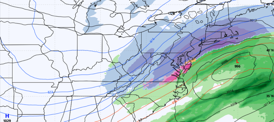
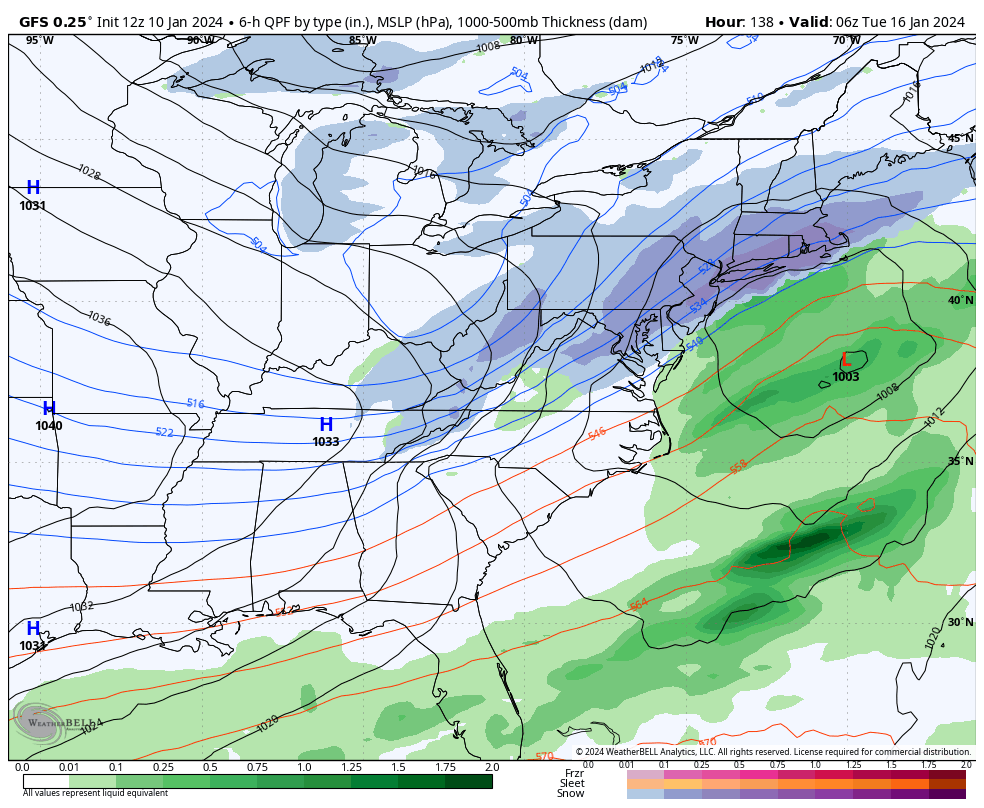
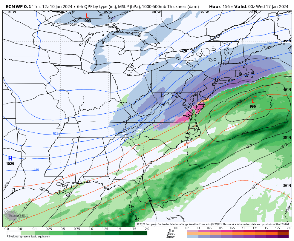
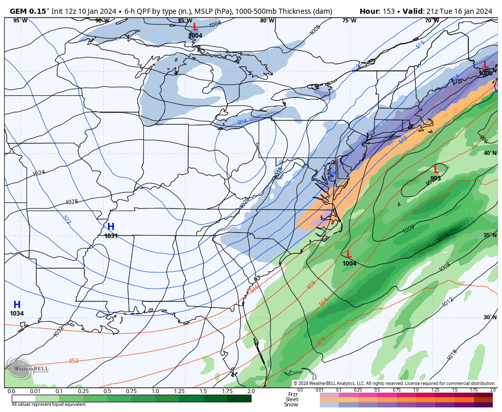
Now let’s talk snow. The January 15-16 signal (next Monday-Tuesday) has been very strongly advertised on long-range model guidance. The developing trough pattern supports a much colder precipitation type for whatever does happen. The departing Friday system again will lay a boundary across the Mid-Atlantic US that the low will track along. The low will Enter the W US from the Pacific Ocean somewhere near Oregon on Saturday, dip and cross the US from Saturday-Sunday night, and then exit into the Atlantic Ocean somewhere near E VA/OBX Monday night. This creates a wintry precipitation opportunity for New Jersey between about Monday afternoon and Tuesday morning. There is a lot of Arctic air moving into the W US right now and that will be pulled into the E US behind Friday’s GLC. So as long as the boundary is pulled S enough, then NJ will be in that colder air for the precipitation. That’s what I am watching at this point. The low itself looks weak, especially to start. It’s more of a flat wave that tries to turn into a CCB at the end. I am reluctant to consider surface details just yet. Need to see another day or two of model consensus. Here’s the latest 12Z GFS, 12Z Euro, and 12Z Canadian runs showing it all come together for now. I imagine models will flip and flop harder than a politician on a nation-wide campaign tour getting caught in a bad situation. But the signal is very much alive from now just 6 days out:
Beyond the Jan 15-16 possibility, there are a few more signals before the Jan 24 time marker which should conclude the Arctic influence and likely set up a January thaw to end January. There are some longer-range signals that the cold reloads back for February. I like to take every 7 days at a time though. So for now, let’s get through the Friday GLC and hopefully some snow early next week.
In English: Breezy/gusty today out of the W/NW as NJ tries its best to dry out. Some are dealing with aftermath flooding issues today. Conditions should continue improving and set up a nicer Thursday (dry and cool). Rain and wind moves back in by Friday afternoon (possibly another wintry start for NNJ elevations) and clears by early Saturday morning, maybe earlier late Friday night. Not as bad as what we went through last night. Saturday then starts a cold period (dry and cold through Sunday) leading into a possible snow event Monday-Tuesday (Jan 15-16). I will update accordingly/daily. Be safe! JC
Premium Services
KABOOM Club offers inside info forecast discussion, your questions answered, and early storm impact maps (ahead of the public). At a buck per month, it’s an extremely feasible way to show support.
My Pocket Meteorologist (MPM), in partnership with EPAWA Weather Consulting, offers professional/commercial interests, whose businesses depend on outdoor weather conditions (snow plowing, landscaping, construction, etc.), with hyper-local text message alerts/forecasts and access to the MPM premium forum—the most comprehensive and technical forecast discussion available for PA and NJ.
Get your KABOOM Inside Out pajamas and more at the KABOOM shop!
Jonathan Carr (JC) is the founder and sole operator of Weather NJ, New Jersey’s largest independent weather reporting agency. Since 2010, Jonathan has provided weather safety discussion and forecasting services for New Jersey and surrounding areas through the web and social media. Originally branded as Severe NJ Weather (before 2014), Weather NJ is proud to bring you accurate and responsible forecast discussion ahead of high-stakes weather scenarios that impact this great garden state of ours. All Weather. All New Jersey.™ Be safe! JC


LOCAL FORECAST | INTERACTIVE RADAR | LATEST NJ WEATHER ALERTS | WEDDING FORECAST| PRIVACY POLICY
© Copyright 2026 Weather NJ LLC. All Rights Reserved.
Some information that can be found on our website is provided by a private weather station and is not an officially recognized station for weather reporting. Though we always strive to achieve accurate reporting for our own use, it is important that you do NOT depend on the data provided here for any purpose.
