

Snow for All of New Jersey Tomorrow
Discussion: Not too long ago, I was assured by a few followers that there would be no more snow in New Jersey for the rest of winter. Sorry, but it doesn’t work that way. Runs can be scored just as easily in the 9th inning of winter as in the 1st. Right now, we are into the 8th inning with at least 4-5 outs left. As a great long-range forecaster once taught me, “It’s going to snow where it wants to snow, when it wants to snow.” Between tomorrow’s snowfall and the potential Feb 22-24 signal, many NJ areas might actually catch up to seasonal averages for winter snowfall. We’ll see. But for now, a statewide light-to-significant snowfall accumulation is likely tomorrow (Saturday) morning which will fill in the CNJ/SNJ areas that were shorted in our recent NNJ KABOOM this past Tuesday…but now also provide NNJ some more.
High temperatures this afternoon have reached a range of 38-44 from NNJ elevations to SNJ coasts. Once the sun sets this evening, temperatures will steadily decline until all NJ locations are at or below freezing (probably by midnight tonight). Temps will then continue to drop as snowfall moves in from the W anytime after midnight. It will be very cold aloft so the snow will pull down additional cold and put most areas N of I-195 into the mid-to-upper 20s. Areas S of I-195 will likely stay in the 28-32 range. This is important because snow ratios will be higher in NNJ than SNJ. But SNJ will see more liquid fall than NNJ. So it kind of works out to a similar outcome with NNJ seeing fluffier snow and SNJ seeing more of a traditional snow (but not wet snow).
The system pushes from W to E across NJ and should clear the ENJ coast by noon Saturday. Let’s allow for a 12-hour total window (midnight tonight through noon tomorrow) for the absolute bookends of possible snowfall with realistically a 6-8 hour period of snowfall within that overall window (likely 2-10am). With all of that said, here is our final call snow map.
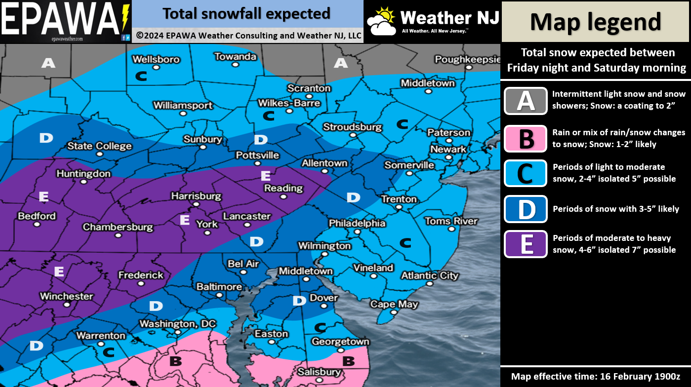
The only wildcard concern I see is neighboring subsidence to the N and/or S of any concentrated snow bands that set up. Something like this might produce a W to E tight swath of 3-6 but then 1-2 to the N and/or S of it. Basic mesoscale banding concerns. If you see or hear any thundersnow, that’s likely happening. Otherwise the snowfall should be even and widespread. No high winds or coastal flooding issues to worry about, just a widespread snowfall.
The Feb 22-24 snowstorm signal is starting to show some life on model guidance. We might be tracking that next week if the signal continues to hold.
In English: Temperatures will fall after sunset and reach 32F or less by midnight for most of NJ. Maybe by 2am for extreme SENJ. Snow will then push into WNJ between midnight and 2am and clear ENJ around 10am-noon. Please see the above snow map for expected snow accumulations on all natural and untreated paved surfaces. Have a great rest of your Friday and please be safe! JC
Premium Services
KABOOM Club offers inside info forecast discussion, your questions answered, and early storm impact maps (ahead of the public). At a buck per month, it’s an extremely feasible way to show support.
My Pocket Meteorologist (MPM), in partnership with EPAWA Weather Consulting, offers professional/commercial interests, whose businesses depend on outdoor weather conditions (snow plowing, landscaping, construction, etc.), with hyper-local text message alerts/forecasts and access to the MPM premium forum—the most comprehensive and technical forecast discussion available for PA and NJ.
Get your KABOOM Inside Out pajamas and more at the KABOOM shop!
Jonathan Carr (JC) is the founder and sole operator of Weather NJ, New Jersey’s largest independent weather reporting agency. Since 2010, Jonathan has provided weather safety discussion and forecasting services for New Jersey and surrounding areas through the web and social media. Originally branded as Severe NJ Weather (before 2014), Weather NJ is proud to bring you accurate and responsible forecast discussion ahead of high-stakes weather scenarios that impact this great garden state of ours. All Weather. All New Jersey.™ Be safe! JC


LOCAL FORECAST | INTERACTIVE RADAR | LATEST NJ WEATHER ALERTS | WEDDING FORECAST| PRIVACY POLICY
© Copyright 2026 Weather NJ LLC. All Rights Reserved.
Some information that can be found on our website is provided by a private weather station and is not an officially recognized station for weather reporting. Though we always strive to achieve accurate reporting for our own use, it is important that you do NOT depend on the data provided here for any purpose.
