

Snow in Southern NJ Tomorrow

Discussion: I know last night and today felt cold but there’s even colder air on its way this evening behind the cold front that’s currently pushing NW to SE over the Appalachian Mountains into NJ. I expect it to be through NJ later this evening and you can’t rule out flurries this afternoon/evening just from the much colder air squeezing moisture out of the current air mass. There is some lift with the front itself that could do this and I am seeing it happen across PA and in some NJ areas now. Flurries only though today. This cold frontal passage then sets the stage for our trace/light event across mainly SNJ tomorrow morning. And yes, it has moved forward in time to tomorrow morning rather than later tomorrow due to a more progressive stream.
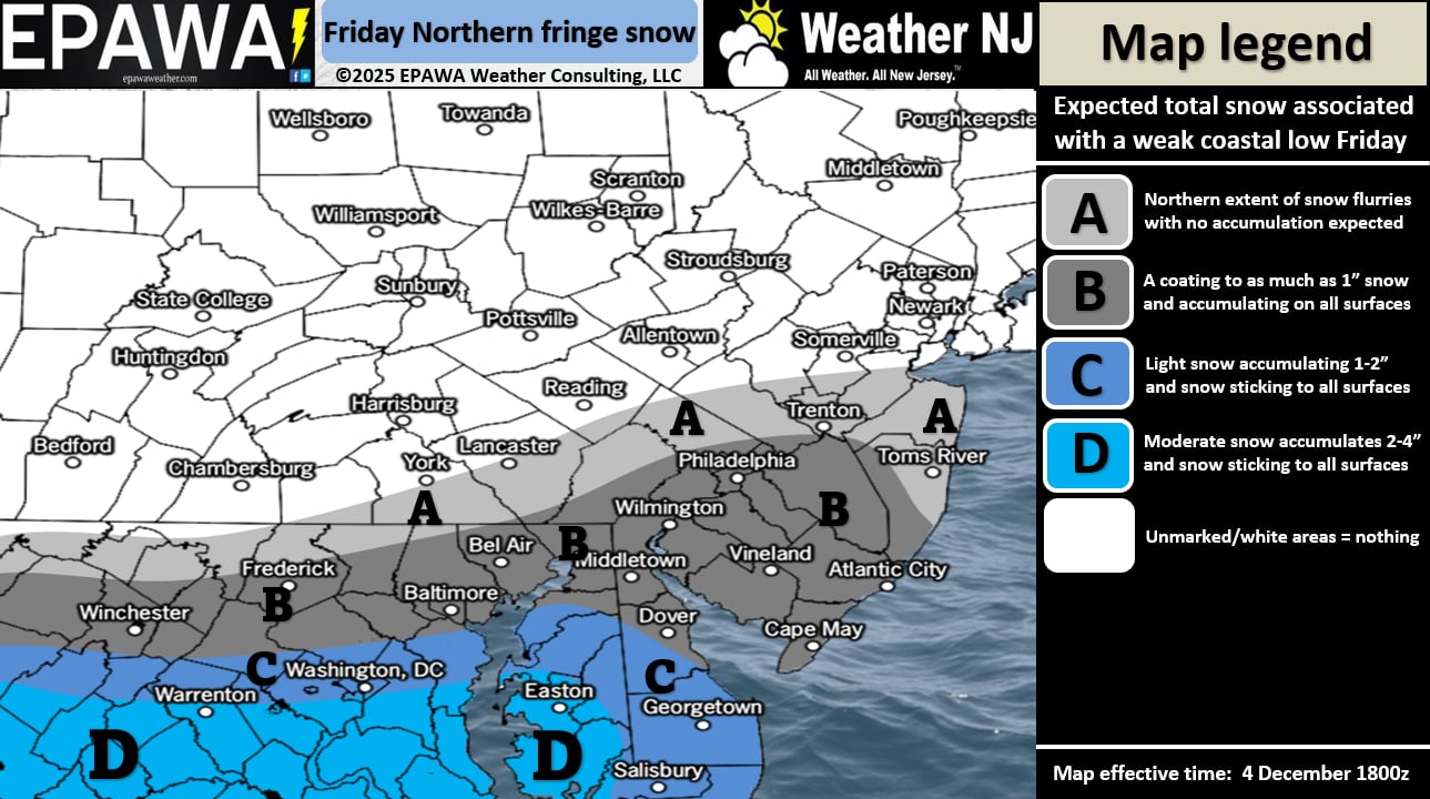
A weak shortwave will push through the Central Mid-Atlantic US and collide with high pressure but not before sending some precipitation into the very cold air (for this time of year – early Dec) over CNJ/SNJ. The actual low should eject into the Atlantic Ocean near the NC/SC border. The actual high track should float across NY State/Massachusetts. Because of the high so far S, it should inhibit snow from falling to the N of the Mason Dixon line extended through SNJ, certainly not N of I-195. The high will be taking its toll on the precipitation shield and ultimately extinguishing it. For that reason, SWNJ has a better chance of snow than SENJ.
In English: Light snow is expected across mainly SNJ tomorrow (Friday) morning but flurries could fly as far N as some of CNJ. Salem, Cumberland, Gloucester, Cape May and maybe some of W Atlantic Counties…you should see the most from this with a 1-inch cap likely. Camden, E Atlantic, S Burlington and S Ocean Counties…you will probably struggle to accumulate more than a dusting/coating IMO. The fade out to flurries only/nothing should occur in N Burlington/N Ocean Counties, if not further S and W than that. But given how cold it will be, anything that falls should stick to all untreated surfaces including roads. We believe the following regional snow accumulations are likely between 6am and noon on Friday, Dec 5, 2025.
I am seeing more snow opportunities over the next few weeks as the cold pattern digs in as expected for December. Be safe! JC
Jonathan Carr (JC) is the founder and sole operator of Weather NJ, New Jersey’s largest independent weather reporting agency. Since 2010, Jonathan has provided weather safety discussion and forecasting services for New Jersey and surrounding areas through the web and social media. Originally branded as Severe NJ Weather (before 2014), Weather NJ is proud to bring you accurate and responsible forecast discussion ahead of high-stakes weather scenarios that impact this great garden state of ours. All Weather. All New Jersey.™ Be safe! JC


LOCAL FORECAST | INTERACTIVE RADAR | LATEST NJ WEATHER ALERTS | WEDDING FORECAST| PRIVACY POLICY
© Copyright 2026 Weather NJ LLC. All Rights Reserved.
Some information that can be found on our website is provided by a private weather station and is not an officially recognized station for weather reporting. Though we always strive to achieve accurate reporting for our own use, it is important that you do NOT depend on the data provided here for any purpose.
