

Snow is Approaching New Jersey
Discussion: It’s go time. It’s not a major snowstorm but it’s go time for some who haven’t seen snow in a while. Our wave has developed enough to start a precipitation shield currently extending through Tennessee, WV, Virginia, Maryland, Delmarva, and now extreme SNJ. This is the main precipitation shield that the surface low will escort through the Mid-Atlantic US between this evening and tomorrow.
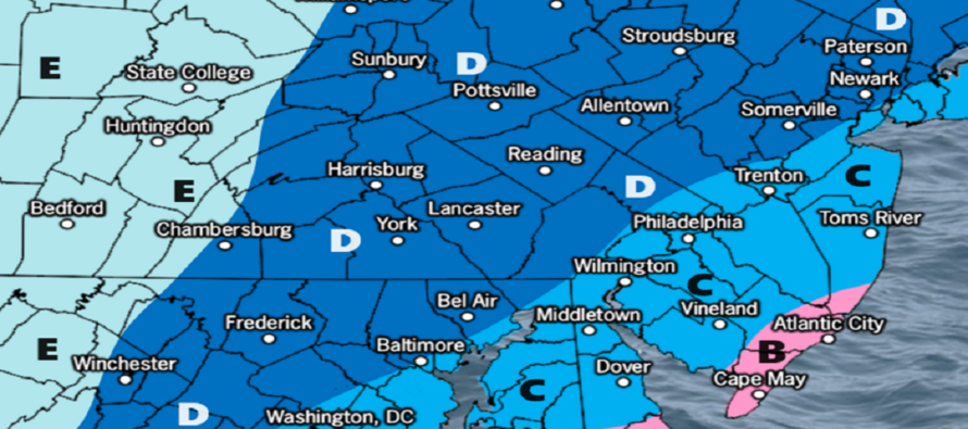
In light of overnight and morning model guidance as well as live observation analysis, we have arrived at the following expected outcome. A slightly colder and snowier outcome than our first map yesterday but still the same idea.
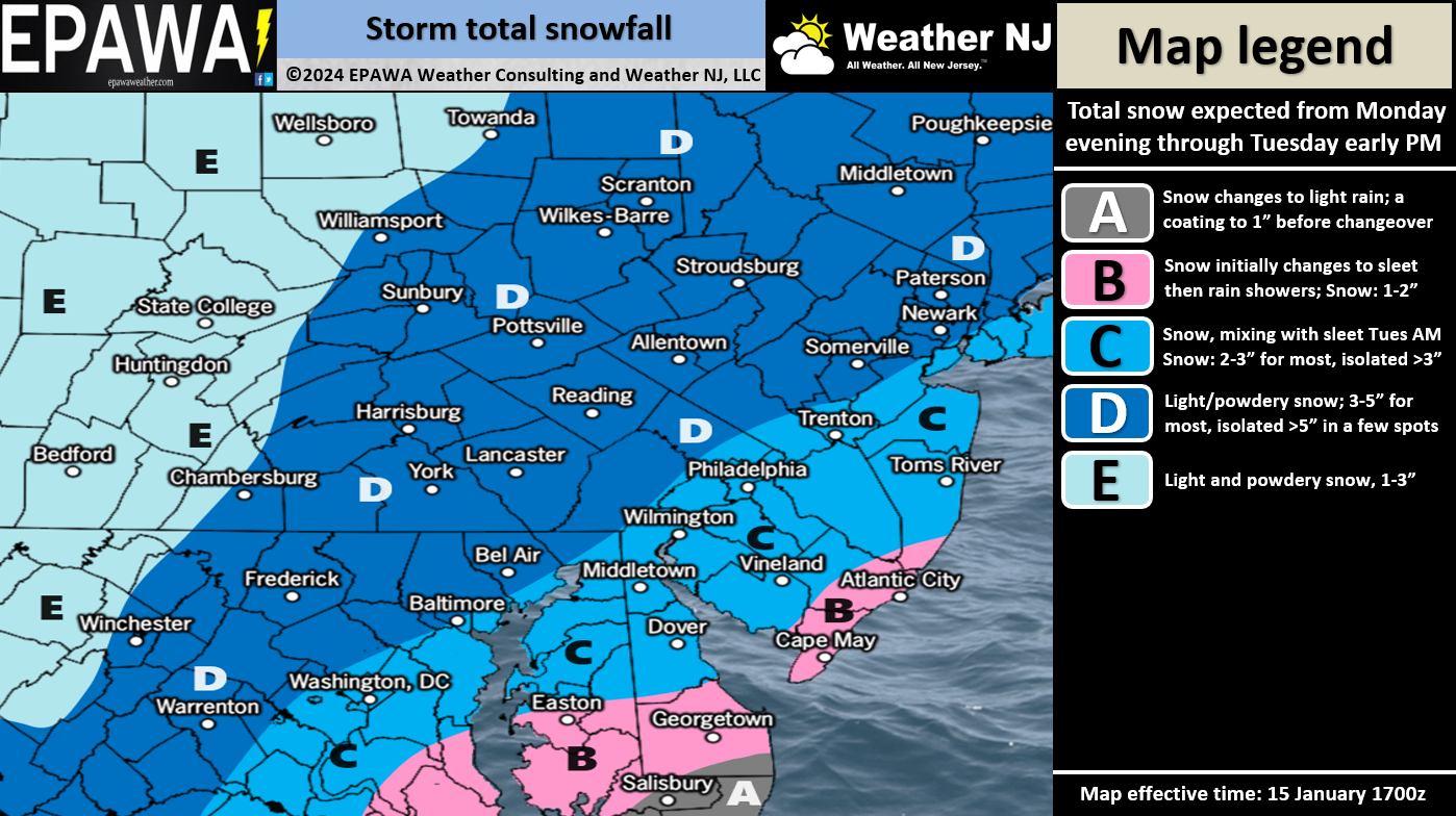
Zone D: This is the jackpot zone of the system with the best chance for a plowable outcome. We feel there will be common amounts of 3-5 inches of snowfall measured here with localized instances of 5+ inches under the heaviest banding. This zone has the lowest chance for any warm-layer mixing to occur Tuesday. Any mixing that does happen would be along the SE border of zone C.
Zone C: This is the zone that has trended snowier. Even though much of this area will eventually warm at a few layers on Tuesday morning, most of the snowfall will have fallen already. The snowpack could then keep the surface colder on Tuesday morning as upper-levels warm with low-mid level marine flow around the low. Maybe these areas only warm to the mid-30s on the surface instead of 40. In either case, anything wet/melted on the ground will re-freeze Tuesday night as Arctic air rushes back into fill the pesky warm layers including the surface. In this area we feel that 2-3 inches of snow will fall and accumulate prior to any changeover to sleet or rain. We’ll allow localized amounts greater than 3 inches to account for heavier isolated banding but don’t hold your breath. It would be a low-probability surprise. We feel this area has a better chance of sleet vs rain after the changeover.
Zone B: This will be the warmest area of the storm, especially Tuesday morning. Snow can still fall and accumulate Monday night through about midnight Tuesday/just after, but this area would likely go over to sleet/rain the quickest which knocks initial accumulations down to anything from a coating to an inch or two before the changeover.
Timing: SNJ snow should start before NNJ as the snow will be generally approaching from the SW. Let’s call it anytime after now. Snowfall should pickup and spread into the rest of NJ in the next few hours. It should snow for all through about midnight. From midnight to sunrise Tuesday, some snow/sleet or snow/sleet/rain lines should start pushing into extreme SENJ. From sunrise to noon, these mixing lines could push as far NW as the I-95 corridor. But precipitation should end for SNJ around sunrise, or just after, so the snow will already be down and trying to hold the surface colder. Precipitation should end for NNJ/CNJ later Tuesday closer to noon (afternoon for NENJ).
In English: A light snow event begins this evening (anytime now for SNJ, slightly later this evening for NNJ) and ends by Tuesday afternoon. The above snow map illustrates our thoughts for snowfall accumulation. Remember, SNJ starts first basically now through midnight/just after for snow accumulation. NNJ is later tonight through later tomorrow afternoon. Good luck to all and be safe! JC
Premium Services
KABOOM Club offers inside info forecast discussion, your questions answered, and early storm impact maps (ahead of the public). At a buck per month, it’s an extremely feasible way to show support.
My Pocket Meteorologist (MPM), in partnership with EPAWA Weather Consulting, offers professional/commercial interests, whose businesses depend on outdoor weather conditions (snow plowing, landscaping, construction, etc.), with hyper-local text message alerts/forecasts and access to the MPM premium forum—the most comprehensive and technical forecast discussion available for PA and NJ.
Get your KABOOM Inside Out pajamas and more at the KABOOM shop!
Jonathan Carr (JC) is the founder and sole operator of Weather NJ, New Jersey’s largest independent weather reporting agency. Since 2010, Jonathan has provided weather safety discussion and forecasting services for New Jersey and surrounding areas through the web and social media. Originally branded as Severe NJ Weather (before 2014), Weather NJ is proud to bring you accurate and responsible forecast discussion ahead of high-stakes weather scenarios that impact this great garden state of ours. All Weather. All New Jersey.™ Be safe! JC


LOCAL FORECAST | INTERACTIVE RADAR | LATEST NJ WEATHER ALERTS | WEDDING FORECAST| PRIVACY POLICY
© Copyright 2026 Weather NJ LLC. All Rights Reserved.
Some information that can be found on our website is provided by a private weather station and is not an officially recognized station for weather reporting. Though we always strive to achieve accurate reporting for our own use, it is important that you do NOT depend on the data provided here for any purpose.
