

Snow Lover Nightmares Continue

Discussion: White rain is becoming the theme of tonight/tomorrow’s snow/rain event. The lower-level environment, especially the critical baroclinic boundary layer, is simply too marginal in the lower levels. March climatology, ground heat retention, and higher sun angle are likely going to win this one out.
The only area of NJ that I might still consider a light, but sloppy, accumulation is N of I-80 and NW of I-287 (primarily elevations). And even there, snow rates will have to overcome a 33-35F surface. For areas S of I-80, I just don’t see snowfall rates taking a near-40F surface down to the point of stickage. Maybe some temporary stickage on grass, trees, etc. but not likely on roads.
The reason for the warmer trend is that the primary is modeled to push further NE before transferring. Up until yesterday it was modeled to encounter the block and stall somewhere near Pittsburg, transferring to a secondary low spawning off S Delmarva/OBX. The last 24 hours of data have trended the primary low into S NY State with a transfer to the secondary just SE of the 40N/70W benchmark. We still see the inverted trough-like area of lifting reach back to mainly NENJ/ECNJ later Saturday morning but it’s way too late and not enough of a snowfall rate to matter. By that time, temps are soaring into the 40s with rising sun. The additional voyage into S NY state allows the primary to surge warmer air into NJ from the SW. This leaves the secondary with too much work to do to chill NJ down.
So the precip is well on it’s way in from the W. Instead of a snow/rain line setting up closer to I-78, it will likely set up N of I-80 and NW of I-287. This will be NNJ’s primary shot of snow from later tonight until around sunrise or just after tomorrow morning. The snow/rain line should start gradually progressing southward after midnight tonight. NNJ precip should shut off earlier tomorrow morning. From then through about noon, the precip should continue changing from rain to snow from N to S through the rest of NJ (likely ECNJ and SENJ) even though the surface will be near-40 with sun rising. Areas with heavier precipitation have a better chance of white rain. Areas with lighter precipitation might stay rain or mix. Here’s our final call map heading into the event:
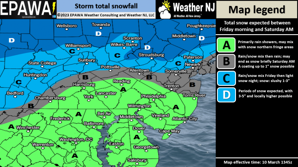
Click here for full resolution impact map!
The Monday-Tuesday system is still modeled to be a much stronger and larger storm system. I’m seeing a sub 985mb low now doing a stall, retrograde, and hook off coastal New England. The Euro continues (even today) to bring much larger snow to NJ than most other model guidance. I would need to see tonight and tomorrow’s other models take serious steps towards such a solution. Even still, there will likely be temperature issues S of I-80 especially for any daytime snowfall. It looks like there’s going to be a strong nor’easter, that much is becoming confident. But a high accumulation event for all of NJ is becoming unlikely. NNJ is the only area of NJ on the Euro still favored for 12-inch+ snow. One more day of monitoring Monday-Tuesday before locking into a forecast.
In English: Precipitation is approaching from the W but temps will remain too warm for snow stickage until later tonight. The system expected tonight/tomorrow has trended warmer over the last 24 hours. Areas N of I-80 and NW of I-287 are the only areas I expect to see a very sloppy snow accumulation. It’s the case where 3-6 inches of snow could fall in this area but only 1-3 actually sticks. Slushy roads possible. For areas S of I-80 and SE of I-287, I drew a red line on the above impact map. Areas S and SE of this line will likely see wet roads only with maybe some sloppy wet snow temporarily sticking to natural surfaces. Please regard traditional travel safety for wet roads but the lower-level temperatures should be too warm (near or above 40F) for snow accumulations, especially on roads below the red line. Monday-Tuesday is looking like a high-impact event for New England but not so much NJ. More temperature issues with NNJ favored for any snow. Will revisit tomorrow. After that there’s maybe one or two more shots later next week before the 9th inning ends with the spring solstice. I’ll post a live observation thread later tonight on social media so most of us can share and appreciate the white rain…or the light slushy accums across NNJ/NWNJ. Be safe! JC
Premium Services
KABOOM Club offers inside info forecast discussion, your questions answered, and early storm impact maps (ahead of the public). At 99 cents per month, it’s an extremely feasible way to show support.
My Pocket Meteorologist (MPM), in partnership with EPAWA Weather Consulting, offers professional/commercial interests, whose businesses depend on outdoor weather conditions (snow plowing, landscaping, construction, etc.), with hyper-local text message alerts/forecasts and access to the MPM premium forum—the most comprehensive and technical forecast discussion available for PA and NJ.
Jonathan Carr (JC) is the founder and sole operator of Weather NJ, New Jersey’s largest independent weather reporting agency. Since 2010, Jonathan has provided weather safety discussion and forecasting services for New Jersey and surrounding areas through the web and social media. Originally branded as Severe NJ Weather (before 2014), Weather NJ is proud to bring you accurate and responsible forecast discussion ahead of high-stakes weather scenarios that impact this great garden state of ours. All Weather. All New Jersey.™ Be safe! JC


LOCAL FORECAST | INTERACTIVE RADAR | LATEST NJ WEATHER ALERTS | WEDDING FORECAST| PRIVACY POLICY
© Copyright 2026 Weather NJ LLC. All Rights Reserved.
Some information that can be found on our website is provided by a private weather station and is not an officially recognized station for weather reporting. Though we always strive to achieve accurate reporting for our own use, it is important that you do NOT depend on the data provided here for any purpose.
