

Snow Map for Tuesday Morning
Discussion: High pressure is moving through the Mid-Atlantic US. It will push cold air downward ahead of it (tonight and tomorrow), setting up a colder environment. The high will then depart the E US into the Atlantic Ocean and draw warmer flow upward in its wake for later Tuesday.
A clipper/wave will traverse the thermal gradient (warm front) and bring precipitation to the region between late Monday night and about noon Thursday, with most precipitation falling between midnight and about 10am on Tuesday. Precipitation will be light however it will take advantage of the colder environment before the warm front advances with the high pressure return flow push. A refresher that the jet pattern is across S Canada from W to E then down over the E Great Lakes and into the Atlantic Ocean over the N Mid-Atlantic US. This also forms the thermal gradient boundary that will be advancing slowly to the NE during precipitation and especially toward the end. The waves travel this boundary like a train track.
So precipitation will arrive overnight Monday night into early Tuesday morning, when it is cold enough to support accumulating snow for all of NJ along and N of I-195. It’s a rather moisture-starved system but still capable of throwing a few inches of snow down in Northern New Jersey. While areas along nearby I-195 could start with a period of snow, the warm front will advance quickly to about the I-78 axis, rendering all to the S of I-78 incapable of accumulating snow beyond a trace-coating closest to I-78. Areas N of I-78 stand the better chance to squeeze out a light accumulation with areas N of I-80 in the best shape for such. For that reason, we only have N Sussex and N/NW Passaic Counties in the 2-4 zone. This is our snow map and call.
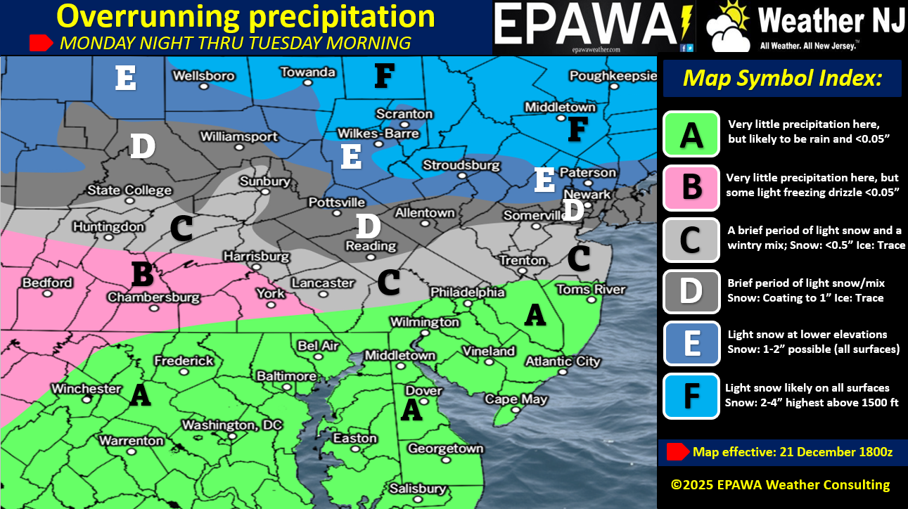
In English: Tonight, we get cold again and that should last through Monday into Tuesday morning. Light snowfall should begin around midnight Monday night and end by Tuesday noonish, all while a line of freezing at the surface advances through the rest of Tuesday. This is not SNJ or even CNJ’s snow system. SNJ is likely to see mostly rain (Zone A). CNJ could see a brief period of snow with little-to-no accumulation as the surface warms S to N (Zone C). NNJ (N of I-78) have the best chance to see a coating to an inch or two (Zones D and E) and N of I-80 has the best chance to get into a 2-4 inch range (Zone F). We’ll take a final look tomorrow but for now, this is our first call expectation. Have a great Sunday night and please be safe! JC
Premium Services
KABOOM Club offers an ad-free environment, inside info (Above and Beyond) forecast discussion, your questions prioritized, and early storm impact maps and video releases (ahead of the public). At $1.99 per month, it’s an extremely feasible way to show additional support for Weather NJ and you can turn it on and off for however many months you wish. Think of it as a tip jar with perks. Available onFacebook or Patreon.
My Pocket Meteorologist (MPM), in partnership with EPAWA Weather Consulting, offers professional/commercial interests, whose businesses depend on outdoor weather conditions (snow plowing, landscaping, construction, etc.), with hyper-local text message alerts/forecasts from real meteorologists and access to the MPM premium forum—the most comprehensive and technical forecast discussion available for PA and NJ commercial interests.
KABOOM Shop is live if you want some KABOOM or Weather NJ Merch!
Sign up for ZoneWatch Radar and get 10% off
Jonathan Carr (JC) is the founder and sole operator of Weather NJ, New Jersey’s largest independent weather reporting agency. Since 2010, Jonathan has provided weather safety discussion and forecasting services for New Jersey and surrounding areas through the web and social media. Originally branded as Severe NJ Weather (before 2014), Weather NJ is proud to bring you accurate and responsible forecast discussion ahead of high-stakes weather scenarios that impact this great garden state of ours. All Weather. All New Jersey.™ Be safe! JC


LOCAL FORECAST | INTERACTIVE RADAR | LATEST NJ WEATHER ALERTS | WEDDING FORECAST| PRIVACY POLICY
© Copyright 2026 Weather NJ LLC. All Rights Reserved.
Some information that can be found on our website is provided by a private weather station and is not an officially recognized station for weather reporting. Though we always strive to achieve accurate reporting for our own use, it is important that you do NOT depend on the data provided here for any purpose.
