

Snow Showers to Ring in the New Year

Discussion: It’s hard to even call this wave a clipper with how weak it is. But a dissolving clipper will push through the Mid-Atlantic US tonight. As far as the snow showers that a clipper typically brings, it really only looks like NNJ will see such. However, it does look like a snow squall will push through overnight. A squall is like a summertime thin strip of precipitation that is convectively created. We expect this to push through across our entire coverage region between late tonight in PA and around/just after sunrise tomorrow morning for our far SENJ areas.
This is not a big deal and will not drop significant amounts of snow. It doesn’t take much to slick things up though, especially in this cold environment on any untreated surfaces. Honestly, the only hazard I’d like to mention is the very brief reduction in visibility that a snow squall can bring, even if just a 5–10-minute ordeal.
Moving forward into January, I am still seeing a solid block develop over Greenland. Whether or not the upstream features (W US ridge, E US trough, etc.) will take advantage of this and produce a snowstorm is still yet TBD. Models are nowhere near a consensus and are only showing a snowstorm every few runs…not enough to sound any alarms. Once this clipper/squall is through, I plan to take a closer look on Friday at what the first half of January could look like.
Here are the wintry impact maps for tonight (Dec 31 – New Year’s Eve) into tomorrow (Jan 1 – New Year’s Day):
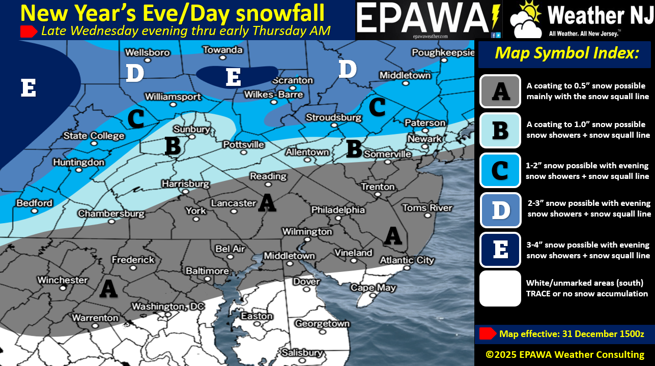
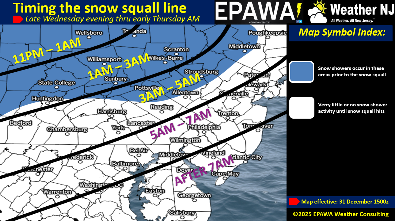
In English: Light snow will push across NJ overnight tonight and ring in the new year with some trace-to-light snow accumulations by morning. Nothing to write home about, especially for CNJ/SNJ. NNJ is most favored to wake up to a fresh white coating to an inch or so. During the brief period of the snow squall, visibility could be reduced so please use some extra caution of driving at that time. Two maps are above, one showing light amounts and the other showing the time expectation of the squall. Once more, Have a Happy New Year and please be safe! JC
Premium Services
KABOOM Club offers an ad-free environment, inside info (Above and Beyond) forecast discussion, your questions prioritized, and early storm impact maps and video releases (ahead of the public). At $1.99 per month, it’s an extremely feasible way to show additional support for Weather NJ and you can turn it on and off for however many months you wish. Think of it as a tip jar with perks. Available onFacebook or Patreon.
My Pocket Meteorologist (MPM), in partnership with EPAWA Weather Consulting, offers professional/commercial interests, whose businesses depend on outdoor weather conditions (snow plowing, landscaping, construction, etc.), with hyper-local text message alerts/forecasts from real meteorologists and access to the MPM premium forum—the most comprehensive and technical forecast discussion available for PA and NJ commercial interests.
KABOOM Shop is live if you want some KABOOM or Weather NJ Merch!
Sign up for ZoneWatch Radar and get 10% off
Jonathan Carr (JC) is the founder and sole operator of Weather NJ, New Jersey’s largest independent weather reporting agency. Since 2010, Jonathan has provided weather safety discussion and forecasting services for New Jersey and surrounding areas through the web and social media. Originally branded as Severe NJ Weather (before 2014), Weather NJ is proud to bring you accurate and responsible forecast discussion ahead of high-stakes weather scenarios that impact this great garden state of ours. All Weather. All New Jersey.™ Be safe! JC


LOCAL FORECAST | INTERACTIVE RADAR | LATEST NJ WEATHER ALERTS | WEDDING FORECAST| PRIVACY POLICY
© Copyright 2026 Weather NJ LLC. All Rights Reserved.
Some information that can be found on our website is provided by a private weather station and is not an officially recognized station for weather reporting. Though we always strive to achieve accurate reporting for our own use, it is important that you do NOT depend on the data provided here for any purpose.
