

Snow Showers Tonight Still Watching Sunday Night
Discussion: This weekend outlook will be in article form as we are still watching Sunday night into Monday morning for potential wintry impacts in New Jersey. But first lets cover the period leading up to that.
A trough, which brought a few colder days, is moving out and giving way to more of a zonal split flow jet pattern. It’s not completely flat W to E but rather a mild arc across the US with W/NW flow leading into NJ. These upper level conditions will be the case and govern conditions for today through Sunday afternoon.
Friday (today) high temperature are maxing in the mid-30s for most NJ locations. Skies are mostly clear/sunny and winds are light out of the W/NW. Overnight lows should fall to the teens/20s with snow showers possible before Saturday morning. A coating to an inch at most of snow accumulation is possible, mainly for NNJ, possibly for CNJ, but less likely for SNJ.
Saturday (Feb 14 – Valentine’s Day) should reach the mid-40s for most NJ locations. Should feel very nice after recent cold and allow for more snow to melt (watch out for re-freezing ice at night). Skies should be mixed with more sun than clouds with light W winds. Overnight lows should fall back into the teens/20s.
Sunday (Feb 15) high temperatures should reach near-40 for most NJ locations. Skies should vary from clearest in NNJ to cloudiest in SNJ (with rain showers possible in afternoon). Winds should be light out of the E/NE. Temperatures will then fall back below freezing for at least NNJ/CNJ heading into the evening. SNJ could stay just above freezing. We are still watching Sunday night into Monday morning for some potential snow. See discussion below.
Monday (Feb 16 – President’s Day) should rise back up to the low-to-mid 40s for most NJ locations. Skies should be mostly cloudy as any precipitation clears and departs by noonish. Winds should be light out of the NE. Overnight lows should fall only to the low-to-mid 30s.
The rest of next week should experience a transient warmup that we identified in the Feb 17-19 period. Highs could reach into the 50s during this time though some nuisance precipitation could occur during colder overnight periods. We are watching Wednesday night and then another disturbance Friday night. Will report accordingly once we’re closer. Now for a more detailed discussion about possible snow this Sunday night into Monday. Temperatures are then expected to return to near or below-average to close out February.
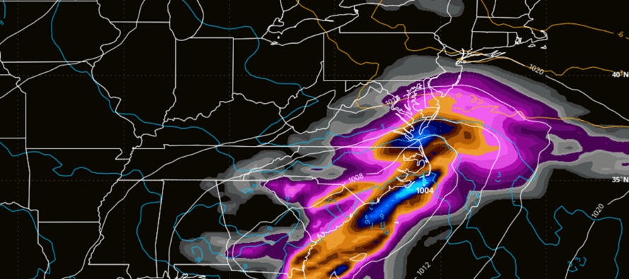
Sunday Night – Monday Morning Snow Discussion. The same upper-level principles we’ve been discussing this week apply. We have a ridge that’s pushing a closed-off upper low (UL) from W to E across the US. The further S the UL is pushed into SE US, the less chance for any NJ snow. However, if the UL is allowed to exit the US more towards the central east coast rather than southern coast, then it could turn the surface low up the coast a bit (not a lot) as a stronger low. From watching these models all week, I’ve established a benchmark. If the low is 1000mb or less (stronger) and reaches Hatteras OBX latitude, then a snowier outcome is likely for more of NJ. However, if the low is above 1000mb and S of Hatteras OBX latitude, then we’re likely looking at a miss to the S of NJ with maybe some rain only for SNJ. This surface low’s intensity and latitude (track) will be governed completely by the UL and how much interaction the UL has with a shortwave on the N stream. In the cases of the more aggressive (snowier) model data, there is a shortwave digging into the upper low which produces lower heights up and down the coast and a stronger UL further N. This is something I will be watching closely on each run. At this point, the most realistic and reasonable expectation is a weaker outcome regarding snow. Again, a marginal temperature environment and a quick moving system. The worst-case maximum snowfall would be a very wet 3-6 inches across NNJ/CNJ with maybe some rain holding down SNJ accumulations. We still can’t take that off the table at this point however we can assign it a lower probability. The more probable expectation is a mix of snow and rain through CNJ/SNJ with little-to-no accumulations. Very wet and favoring natural surfaces if any. The warmest expectation for this system would be rain only for SNJ with no wintry precip involved. I need to see more guidance suggesting such to lean that way. Today, the GFS, GFS AI, GFS ensembles, GFS AI ensembles, Euro, Euro AI, Euro ensembles, and Euro AI ensembles all run at least some level of wet snow through NJ Sunday night into Monday. Tomorrow, the shorter-range models will start getting into their ranges of realistic guidance.
In English: The next few days will be milder during the day but will still become colder overnight thanks to the existing snowpack. Otherwise, nights would correlate milder. In any sense, some snow showers are possible tonight with NNJ most favored. The snow showers will be moving NW to SE so CNJ, and possibly a little of SNJ could eventually get in on that. I would say SWNJ is the least favored. A coating to an inch max of snow is possible, especially for NNJ. We then turn to Sunday night into Monday morning for some possible snow. Coldest case scenario is a very wet cement-like 2-4/3-6 through either CNJ or SNJ. Warmest case scenario is rain-only for SNJ. Chances are we end up somewhere between with the middle-of-the-road scenario being a mix of rain and snow with little-to-no accumulations, very wet snow if any. But that’s the span of uncertainty as of now. After that we should experience even milder days next week but still colder overnights with nuisances possible, some wintry. Let’s take a closer look at that later in the weekend. For now, have a Happy Valentine’s Day and great President’s Day Weekend! Be safe! JC
Premium Services
KABOOM Club offers an ad-free environment, inside info (Above and Beyond) forecast discussion, your questions prioritized, and early storm impact maps and video releases (ahead of the public). At $1.99 per month, it’s an extremely feasible way to show additional support for Weather NJ and you can turn it on and off for however many months you wish. Think of it as a tip jar with perks. Available onFacebook or Patreon.
My Pocket Meteorologist (MPM), in partnership with EPAWA Weather Consulting, offers professional/commercial interests, whose businesses depend on outdoor weather conditions (snow plowing, landscaping, construction, etc.), with hyper-local text message alerts/forecasts from real meteorologists and access to the MPM premium forum—the most comprehensive and technical forecast discussion available for PA and NJ commercial interests.
KABOOM Shop is live if you want some KABOOM or Weather NJ Merch!
Sign up for ZoneWatch Radar and get 10% off
Jonathan Carr (JC) is the founder and sole operator of Weather NJ, New Jersey’s largest independent weather reporting agency. Since 2010, Jonathan has provided weather safety discussion and forecasting services for New Jersey and surrounding areas through the web and social media. Originally branded as Severe NJ Weather (before 2014), Weather NJ is proud to bring you accurate and responsible forecast discussion ahead of high-stakes weather scenarios that impact this great garden state of ours. All Weather. All New Jersey.™ Be safe! JC


LOCAL FORECAST | INTERACTIVE RADAR | LATEST NJ WEATHER ALERTS | WEDDING FORECAST| PRIVACY POLICY
© Copyright 2026 Weather NJ LLC. All Rights Reserved.
Some information that can be found on our website is provided by a private weather station and is not an officially recognized station for weather reporting. Though we always strive to achieve accurate reporting for our own use, it is important that you do NOT depend on the data provided here for any purpose.
