

Snow Targeting CNJ/SNJ Friday
Discussion: The data continues to point towards a significant snow storm in New Jersey SE of the NJTP/I-95 corridor. Even though this system is still capable of delivering more of a widespread/statewide snowfall, amounts NW of the corridor look light. The area right over 95…still some uncertainty but we still have some time to flesh out.
Our vort timing and trough tilt are likely locked at this point. What’s going to make the difference, one way or another, is the interaction of the primary surface low coming in from the W and the weaker coastal low coming up from the Bahamas. For more snow you want to see the primary take over and absorb the coastal low as early as possible (like the Euro, Canadian, and NAM are now doing). The GFS and NAM are seeing later interaction which would mean lower side of expectations. We are leaning towards the latter (towards the Euro ECM/Canadian RGEM/NAM 3Km) for the primary jackpot area SE of NJTP/I-95.
After dropping temperatures Thursday, snow should approach NJ from the W/SW by midnight Thursday night. Snow should then spread throughout NJ between ~midnight and 5am Friday morning, peak from about 5am to 10am and taper off by noon from W to E.
Coastal regions are not looking at major flooding with this. The winds are onshore for a little bit Friday morning but quickly change to N/NW. Not enough time IMO for ECNJ/SENJ coastal flooding to exceed minor levels. The strongest winds should be later Friday after precipitation has ended and the system is pulling away. The W/NW flow should instead push out the tide.
The below represents where we stand today for late Thursday night through about noon on Friday. Coastal regions of ECNJ/SENJ are the most uncertain being closest to the warmer ocean and low pressure center. We’re talking about the first 5 miles or so from the ocean. If those areas stay cold enough then they will behave like the rest of the SENJ jackpot. Otherwise, marine air could keep totals slightly lower along those immediate coasts. The ocean is still in the upper-40s. For this reason, our map has that coastal strip in area B instead of C. The other end of uncertainty is whether the area along and just NW of NJTP/I-95 behaves more like area C. Temperatures will be colder there and could allow higher snow ratios. Therefore, if the C area expands a little bit NW and SE for tomorrow’s updated map, I would not be surprised. It would put most of SNJ and some parts of CNJ in the C zone. The latest NAM is starting to indicate that but we’ll see. You’ll notice the locally higher caveat mentioned on the map to account for where mesoscale banding could drive some over 6″ but this would come at the cost of reducing neighboring areas. These mesoscale details can only be identified in real-time last minute. But again, this is our general expectation:
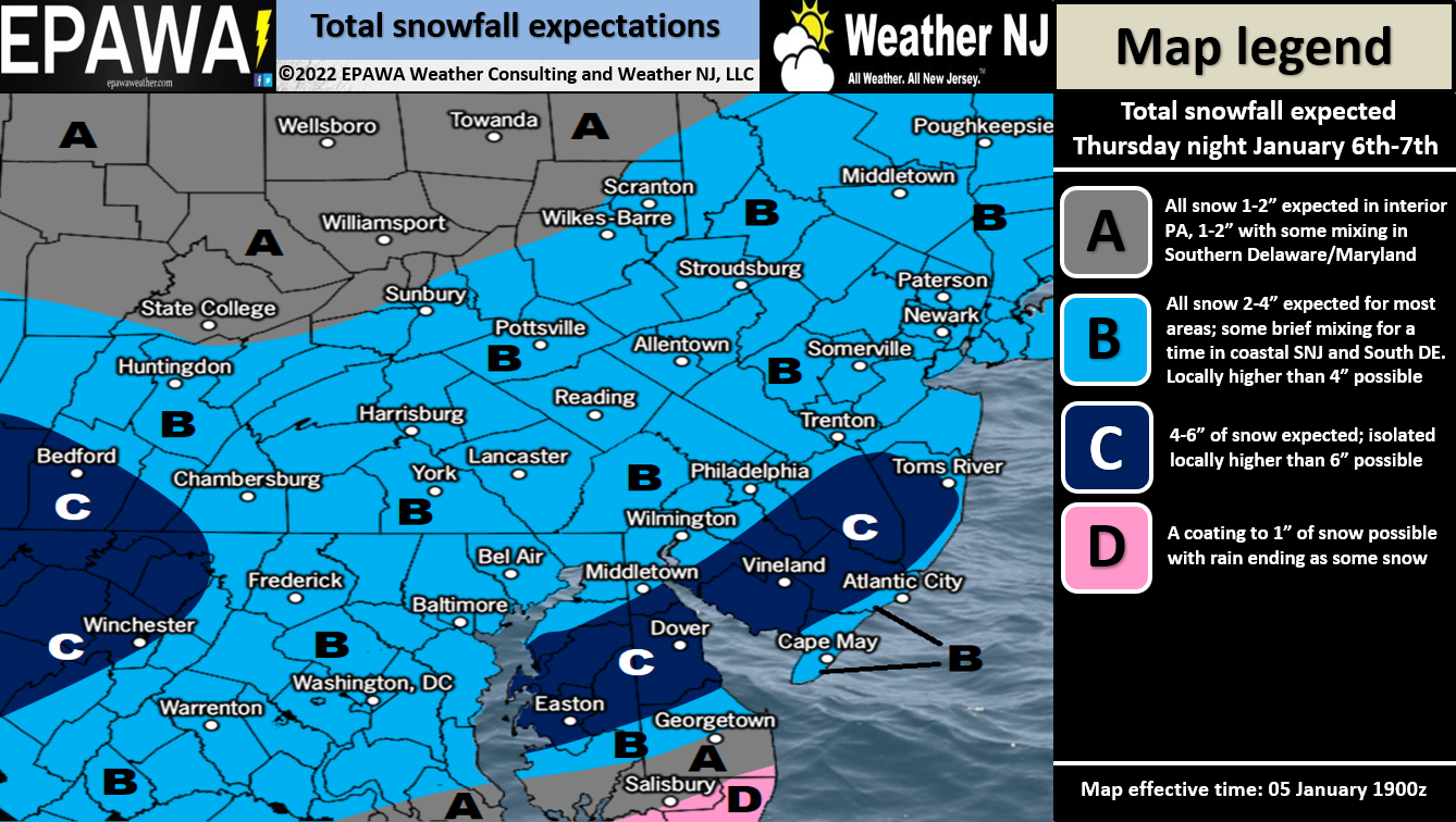
Full Resolution Snow Impact Map
In English: Another snowstorm is likely late this Thursday night through about noon Friday (general window). We expect the above amount of snow to fall in that period. A lighter event NW of the turnpike and a significant event SE of such. It’s not a major snowstorm but still plowable and disruptive for many. Tomorrow, we’ll make any needed adjustments on the map one last time before nowcasting begins later tomorrow night. Have a great rest of your Wednesday and please be safe! JC
Download the free Weather NJ mobile app on Apple or Android. It’s the easiest way to never miss Weather NJ content. Our premium services go even further above and beyond at the hyper-local level.
Jonathan Carr (JC) is the founder and sole operator of Weather NJ, New Jersey’s largest independent weather reporting agency. Since 2010, Jonathan has provided weather safety discussion and forecasting services for New Jersey and surrounding areas through the web and social media. Originally branded as Severe NJ Weather (before 2014), Weather NJ is proud to bring you accurate and responsible forecast discussion ahead of high-stakes weather scenarios that impact this great garden state of ours. All Weather. All New Jersey.™ Be safe! JC


LOCAL FORECAST | INTERACTIVE RADAR | LATEST NJ WEATHER ALERTS | WEDDING FORECAST| PRIVACY POLICY
© Copyright 2026 Weather NJ LLC. All Rights Reserved.
Some information that can be found on our website is provided by a private weather station and is not an officially recognized station for weather reporting. Though we always strive to achieve accurate reporting for our own use, it is important that you do NOT depend on the data provided here for any purpose.
