

Snow to Graze North Jersey Sunday-Monday AM
Discussion: We are supposed to be in a warmer non-snowy pattern right now…between the colder pattern earlier this month and before the colder pattern to set up in February. However sometimes a system threads the needle in a crappy pattern. High pressure to the direct N meets low pressure to the direct S and squeezes one out on us. That’s what we’re working with for Sunday into Monday.
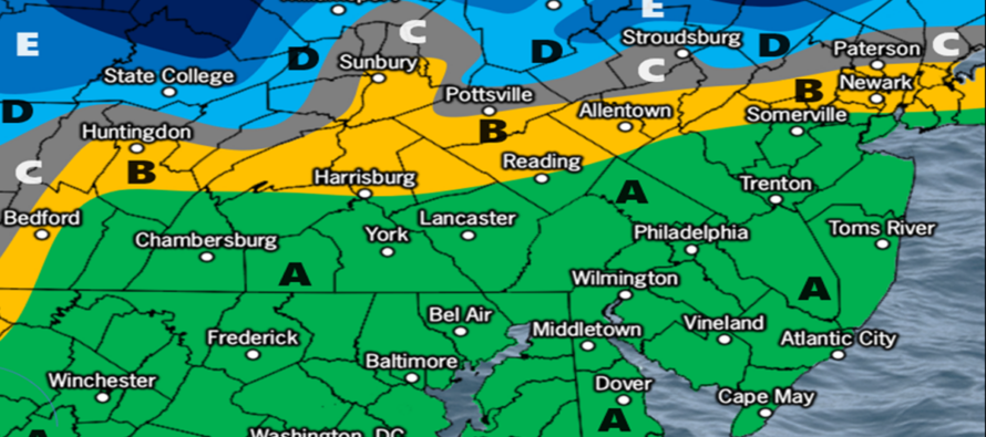
I’ve never liked this system for snow S of I-80. A few fantasy runs tried to juke us into something colder S f I-80 (The Euro 2 days ago and today’s GFS) but most guidance is uniting in most wintry impacts remaining to the N of I-80. We’re in a break in the rain now though it’s still pretty misty/foggy. We’ll stay in the warmer pattern right into Sunday when rain returns but temperatures start dropping from N to S. Earlier this week there was a stronger cold injection modeled which crashed through the precipitation shield as far down as I-95. However most model guidance is suggesting a weaker high and ultimately less of a cold injection. Thus, mainly focusing on areas of NJ N of I-80.
Another trend is timing. What originally looked like a Monday event has rocked forward to a Sunday morning through Sunday night event, maybe some of early Monday AM. Regardless of what time precipitation moves in as rain Sunday morning, it could start changing over by late-morning. If any ENJ areas (S of I-80) are going to see a snowier surprise, it would be later Sunday night into early Monday morning. But right now, the trends are away from that.
I’m much more excited about the colder wintry pattern setting up for February. I will write more to it once we are through with this NNJ graze on Monday.
In English: The rain has taken a break but still some misty/foggy conditions around. Rain should hold off returning until late Saturday night or early Sunday morning. Rain could then change to snow and accumulate N of I-80 between late-Sunday morning and Sunday evening. The highest elevations of Sussex County would stand the best chance to jackpot a significant event. Otherwise this seems like a weak sauce graze at this point. Will update accordingly tomorrow ahead of the approaching precipitation. Have a great weekend and please be safe! JC
Premium Services
KABOOM Club offers inside info forecast discussion, your questions answered, and early storm impact maps (ahead of the public). At a buck per month, it’s an extremely feasible way to show support.
My Pocket Meteorologist (MPM), in partnership with EPAWA Weather Consulting, offers professional/commercial interests, whose businesses depend on outdoor weather conditions (snow plowing, landscaping, construction, etc.), with hyper-local text message alerts/forecasts and access to the MPM premium forum—the most comprehensive and technical forecast discussion available for PA and NJ.
Get your KABOOM Inside Out pajamas and more at the KABOOM shop!
Jonathan Carr (JC) is the founder and sole operator of Weather NJ, New Jersey’s largest independent weather reporting agency. Since 2010, Jonathan has provided weather safety discussion and forecasting services for New Jersey and surrounding areas through the web and social media. Originally branded as Severe NJ Weather (before 2014), Weather NJ is proud to bring you accurate and responsible forecast discussion ahead of high-stakes weather scenarios that impact this great garden state of ours. All Weather. All New Jersey.™ Be safe! JC


LOCAL FORECAST | INTERACTIVE RADAR | LATEST NJ WEATHER ALERTS | WEDDING FORECAST| PRIVACY POLICY
© Copyright 2026 Weather NJ LLC. All Rights Reserved.
Some information that can be found on our website is provided by a private weather station and is not an officially recognized station for weather reporting. Though we always strive to achieve accurate reporting for our own use, it is important that you do NOT depend on the data provided here for any purpose.
