

Snowstorm Approaching!
Discussion: This is now a lower-end Significant East Coast Storm (SECS) expectation. That’s right, weak SECS. We’ve beaten it to death since around Dec 3-5 (for subscribers) when the signal was identified and here it is coming to fruition.
A clipper system is over the US and on its way to the Mid-Atlantic US along with Arctic air on its back. It will get to about W PA and then transfer and redevelop to a coastal low just offshore of Delmarva/OBX. This low will develop and fadeaway to the E while enhancing snowfall rates over NJ and much of the Mid-Atlantic US/I-95 corridor.
I am expecting enhancement of snowfall rates from a combination of higher snow ratios (it now looks even colder aloft), upper jet steak enhancement, a more meridional tilt to the thermal gradient, and the rapidly cooling coastal plain later this evening/tonight that could also contribute to convective mechanisms (heat rising). For said reasons, we have increased the upper end of the jackpot zone to 3-6 instead of 3-5 and placed all of NNJ in the 2-4 zone. Extreme SNJ remains unchanged as initial precipitation will take some time to begin sticking dur to the cooling surface (where it will be the warmest today). Otherwise, don’t let those temps spiking into the 40s today across the coastal plain spook you.
After the sun is down and especially once precipitation starts, it will cool the surface very fast…just a little longer for extreme SNJ (zones C and B). I expect minimal rain, if any, tonight to start. I still think it will be more of a snow that falls and takes a little bit to stick (for areas SE of I-95). I believe this because after 6pm, it will be below freezing 1500 feet above the surface and up. So the shallow above freezing lower-lever/surface layer should collapse quickly. Since we’ll be close to freezing at the start of precipitation, expect 10:1 ratio snowfall at the start. As the system carries on overnight and into Sunday morning, snow ratios should increase as the environment continues to cool aloft and at the surface. That will transition the snow type from average (not extremely wet) to more of a dry fluffy snow that accumulates faster and higher for the second half of the system. Snow ratios could be as high as 15-20:1 for the back 9 of the system…a main reason for the slight increase in accumulation expectations on today’s snow map.
Wildcards still stand for some to exceed the 6-inch mark in the jackpot zone. Probability is not strong enough for this to factor it into the snow map. However, just know that this could bust high in a few places if the band, that I think has a good chance of setting up, sets up somewhere between CNJ and SNJ. There is still maximum upside potential for this becoming a major snowstorm as the progressive system (quick in and out without blocking to slow it) moves through. If this low slowed down and deepened more, we’d be using the K-word. But I don’t think that will happen even in the most crazy convective banding. Wildcard on the other side would be a slightly warmer/slower to cool extreme SNJ/SENJ really knocking down accumulations. Such wildcards cannot be called until they unfold in real-time and why meteorology is an incomplete science. We do the best we can with the data we do have.
Timing is bumped forward a little. I would expect first flakes to fly anytime after 8pm tonight. This would put the W side of NJ under the heaviest snowstorm conditions between about 10pm tonight and 8am Sunday morning. It puts the E side of NJ under such from about midnight to 10am Sunday morning. ECNJ/SENJ will be last to finish closer to 9-10am Sunday morning as snowfall shuts off from NW to SE…maybe more like from W/NW to E/SE. We can then expect a very cold Sunday night into Monday as Arctic air move over fresh snowpack. I think that covers everything. With that said, here’s out final call snow map for tonight through Sunday morning.
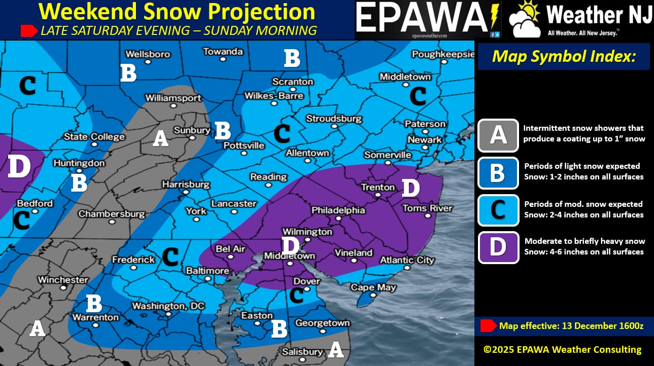
In English: Statewide snow is expected to fall between 8pm tonight and 10am Sunday moring (general window). Heaviest snow 10pm-8am for WNJ and midnight-10am for ENJ. Snow starts wetter and ends fluffier as temperatures drop through the entire event. The snow map above illustrates our final call heading in. For the “I’ll believe it when I see it” and “It’s not going to snow because it’s 44 degrees” people in SENJ, sit this one out. You are contributing nothing to the discussion and it makes you sound foolish/disrespectful. Otherwise, snow lovers in the snow-starved areas of lower 2/3 of NJ, prepare to rejoice! Have a great Saturday and please be safe! JC
Premium Services
KABOOM Club offers ad-free content, inside info forecast discussion, your questions answered, and early storm impact maps and video releases (ahead of the public). At $1.99 per month, it’s an extremely feasible way to show additional support for Weather NJ and you can turn it on and off for however many months you wish. Think of it as a tip jar with perks. Available onFacebook or Patreon.
My Pocket Meteorologist (MPM), in partnership with EPAWA Weather Consulting, offers professional/commercial interests, whose businesses depend on outdoor weather conditions (snow plowing, landscaping, construction, etc.), with hyper-local text message alerts/forecasts from real meteorologists and access to the MPM premium forum—the most comprehensive and technical forecast discussion available for PA and NJ.
KABOOM Shop is live if you want some KABOOM or Weather NJ Merch!
Jonathan Carr (JC) is the founder and sole operator of Weather NJ, New Jersey’s largest independent weather reporting agency. Since 2010, Jonathan has provided weather safety discussion and forecasting services for New Jersey and surrounding areas through the web and social media. Originally branded as Severe NJ Weather (before 2014), Weather NJ is proud to bring you accurate and responsible forecast discussion ahead of high-stakes weather scenarios that impact this great garden state of ours. All Weather. All New Jersey.™ Be safe! JC


LOCAL FORECAST | INTERACTIVE RADAR | LATEST NJ WEATHER ALERTS | WEDDING FORECAST| PRIVACY POLICY
© Copyright 2026 Weather NJ LLC. All Rights Reserved.
Some information that can be found on our website is provided by a private weather station and is not an officially recognized station for weather reporting. Though we always strive to achieve accurate reporting for our own use, it is important that you do NOT depend on the data provided here for any purpose.
