

Snowstorm Approaching New Jersey
Discussion: You can roll up yesterday’s first call snow map and throw it in the garbage. The trend northward in model guidance that occurred between Saturday and Sunday morning juked everyone out of their socks including us and even the National Weather Service. We had extreme NNJ in the KABOOM zone but it’s now time to shift that southward. A correction in data occurred between yesterday afternoon and this morning that has us right back to a few days ago when bigger snow was showing across NNJ/CNJ. With that said, our official and final forecast today for this approaching winter storm will increase snow totals across NJ.
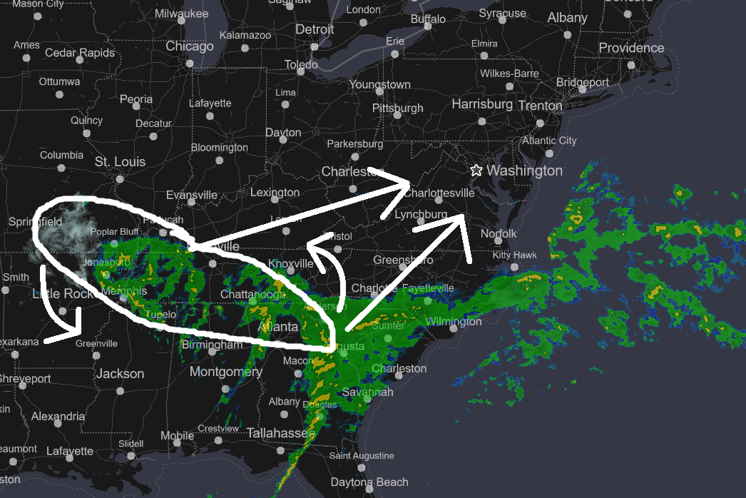
If you look at current radar (above), you will see a strong SubTropical Jet (STJ) feeding the SE US from the Gulf of Mexico. This is the southern branch of energy. You will also see a small cyclonic snowstorm to the NE of the STJ exiting Oklahoma and moving towards Kentucky. This is the northern branch of energy. The two pieces of energy will phase (come together and share common cyclonic vorticity) to produce our storm for NJ. Later today, you will see the two areas on radar merge into a single precipitation shield spanning from Kentucky/WVA through PA and NJ into NYC and New England. The low will then consolidate as it ejects into the Atlantic Ocean somewhere near E VA/S Delmarva early Tuesday AM and rapidly deepen to a sub-990mb cyclone, possibly even a sub-980mb cyclone by Tuesday noonish (just S of Cape Cod). I’ve circled the area that will pivot as indicated and become our storm by early Tuesday AM. The low will then clear away further to the NE and pull-down colder air to kickstart our pattern change. And btw, I am already seeing 3 possible systems this coming weekend through next week. A few clippers and then something bigger. But let’s get through this one first. The snow map is a little complex but I will walk you through zone-by-zone for New Jersey impacts.
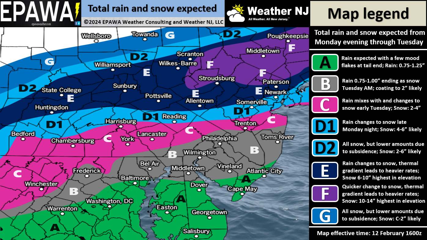
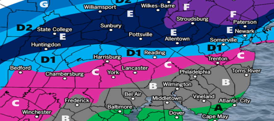
Zones F and E: These are your KABOOM zones through NNJ. We’re a little more confident in locations seeing a foot+ in zone F than E but realistically either zone could see it and for that reason, I have zones F and E in the KABOOM warning zone (basically N of I-78/just N of EWR). To be clear, we are not expecting a widespread 12+ across all of NJ N of I-78. Our ranges state our range of general expectations. But we do think there will be spots greater than 12 inches of snow, especially the elevations. The snow/rain line should begin somewhere near I-80 later tonight (around midnight or 1am) before it starts crashing to the coast through Tuesday morning with heavier precipitation. It should puke snow in these zones from early Tuesday AM through Tuesday afternoon/early evening which should mitigate any surface temperature issues regarding stickage. It is still a reasonable assumption at lower elevations here that snow will stick to natural surfaces slightly better than roads, especially treated roads…but less likely of an issue for higher elevations.
Zone D1: Please ignore D2 as it only applies to areas outside of NJ. D1 sees a little more up-front rain tonight/Tuesday AM before changing over to snow. But we still think this areas sees a plowable 4-6 inch outcome when all is said and done later Tuesday. This zone starts to get into greater surface temperature issues which should be seen as snow sticking better on natural surfaces than roads. But still likely plowable.
Zone C: This zone will see even more rain than D1 before changing over to snow. It will also see even greater surface temp issues than D1. For these reasons, we are allowing 2-4 inches of sloppy wet snow after the changeover, likely by mid-Tuesday morning. Far-east areas of zone C could face stronger coastal winds and coastal flooding.
Zone B: This zone should see a decent amount of rainfall Tuesday morning while areas further N and NW are puking snow. However, we are seeing this area end with a burst of snow that could drop a coating to an inch or two, mainly on natural surfaces. It’s going to be hard for anything to stack S of Philly<->Toms River latitude IMO, especially along the immediate coast. But it could be a nice conversational snow to end. The more important safety hazards for this area are likely gusty coastal winds and coastal flooding.
Zone A: This area should see mostly rain from start to finish with a small chance to end as non-accumulating snowflakes. Biggest hazards for this area are gusty coastal winds and coastal flooding.
Coastal Flooding and Winds: As low pressure makes its way across S Delmarva/E VA Tuesday morning, it will be strengthening/deepening. The Jersey shore (Sandy Hook to Cape May) should see a period of onshore flow/wind-driven storm surge from about mid-Tuesday AM through Tuesday noon. By Tuesday afternoon/evening, the low should be E of NJ producing N flow and mitigating/subsiding surge-related flooding concerns. There are two high tides of concern. First is just before noon on Tuesday and the other later Tuesday night just before midnight. The former has the better chance for coastal flooding than the latter. Both seem to be minor coastal flooding concerns however let’s allow for isolated moderate pockets again from Sandy Hook down through Cape May. Coastal winds should begin picking up early Tuesday AM, possibly just before midnight tonight, and then flex between mid-morning and afternoon Tuesday as coastal low deepens. Thinking gusts in the 35-45mph range, maybe iso 50mph, right along the immediate coast. Wind-related power outages are possible for said areas. Far less winds away from the ocean.
Timing: Precipitation should approach WNJ/SWNJ tonight by 8pm and spread into the rest of NJ by around midnight as mostly rain. Extreme NNJ should flip to snow almost immediately (midnight/1am) with a snow/rain line somewhere near or just N of I-80. From then to about 7am Tuesday morning, the snow/rain line should crash from I-80 to about I-95. Then from about 7am Tuesday morning to noon, the snow/rain line should crash from I-95 to the SENJ coast. NJ will then only have a few more hours Tuesday afternoon to snow before the system clears W to E. Areas N/NW of 95 snow the longest so they see the most snow accumulations. Areas SE of 95 have a smaller snow window after the changeover and therefore see the least snow accumulations. It all clears out for a cold Tuesday night.
In English: Rain arrives tonight (as early as 7pm) and spreads into all of NJ by midnight. It then quickly changes over to snow for NNJ (by 1am). The snow/rain line will then push SE through the rest of NJ through Tuesday morning/noon so that all of NJ eventually ends as snow by Tuesday noon/afternoon. NNJ sees the longest duration of snowfall with the coldest surface temperatures and therefore has the best chance to KABOOM. CNJ sees a less duration of snowfall than NNJ but likely still plowable despite a marginal surface temperature setup being overridden by colder precipitation. SNJ sees the shortest duration of snowfall after the changeover with the warmest (above-freezing) surface temperatures. It could snow VERY HARD for even SNJ/SENJ Tuesday morning but surface temperatures are going to inhibit accumulations, especially on roads. The last thing I want to say about this storm system is that it is very volatile. It’s taken most forecasters for a ride the last 24-48 hours and it might not be finished. With that said, there could be a small chance that it’s not yet finished trending southward and colder even in these last 6-12 hours or so before the changeover. So let’s allow a small wildcard chance for an even colder and snowier outcome across parts of CNJ and even SNJ…an outcome that could bust zones A, B, and C a little low…and possibly even rob a bit from NWNJ. I am baffled at how quickly this is trending colder but this could easily bring I-95/NJTP into the bigger snow if it trends any colder. I will scream this in a live obs post this evening if it appears so. Minor coastal flooding is likely, possibly isolated pockets of moderate, for both high tides on Tuesday (just before noon and just before midnight). Winds should gust along the coast Tuesday morning/afternoon up to 45mph give or take 5mph. Much less wind away from the ocean for rest of NJ. This system is thread-the-needle, but it kicks off a favorable pattern change for snowstorm development. I’m already starting to track two potential events this coming weekend and something larger next week. Live observations for this storm begin this evening. Have a great rest of your Monday and please be safe! JC
Premium Services
KABOOM Club offers inside info forecast discussion, your questions answered, and early storm impact maps (ahead of the public). At a buck per month, it’s an extremely feasible way to show support.
My Pocket Meteorologist (MPM), in partnership with EPAWA Weather Consulting, offers professional/commercial interests, whose businesses depend on outdoor weather conditions (snow plowing, landscaping, construction, etc.), with hyper-local text message alerts/forecasts and access to the MPM premium forum—the most comprehensive and technical forecast discussion available for PA and NJ.
Get your KABOOM Inside Out pajamas and more at the KABOOM shop!
Jonathan Carr (JC) is the founder and sole operator of Weather NJ, New Jersey’s largest independent weather reporting agency. Since 2010, Jonathan has provided weather safety discussion and forecasting services for New Jersey and surrounding areas through the web and social media. Originally branded as Severe NJ Weather (before 2014), Weather NJ is proud to bring you accurate and responsible forecast discussion ahead of high-stakes weather scenarios that impact this great garden state of ours. All Weather. All New Jersey.™ Be safe! JC


LOCAL FORECAST | INTERACTIVE RADAR | LATEST NJ WEATHER ALERTS | WEDDING FORECAST| PRIVACY POLICY
© Copyright 2026 Weather NJ LLC. All Rights Reserved.
Some information that can be found on our website is provided by a private weather station and is not an officially recognized station for weather reporting. Though we always strive to achieve accurate reporting for our own use, it is important that you do NOT depend on the data provided here for any purpose.
