

Snowstorm Approaching New Jersey
Discussion: Our snowstorm is approaching New Jersey and will soon be here. As we’ve always been advertising, this is a quick mover with no blocking to slow it down. However, we have some powerful upper and mid-level dynamics that should help pack a punch in the quick hit.
Beneath the powerful 250mb jet streak and 500mb lower geopotential heights, we have two surface lows coupling up. One is approaching from AL/TN (the primary) and the other is tracking straight up the offshore waters from Bahamas to NJ. They will eventually merge and pop a singular low that should track from ~VA Beach latitude area towards the 40N/70W benchmark between late tonight and tomorrow morning. During this time, the surface low should drop from about 1004mb to 996mb. On the N and W side of this singular surface low will exist the statewide precipitation shield for New Jersey.
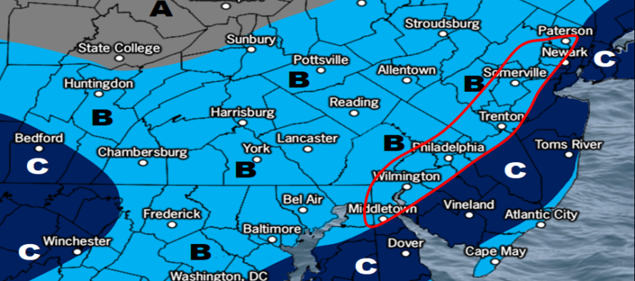
We still think that areas SE of NJTP/95 will see the jackpot 4-6+ zone. However we are thinking that areas right along this corridor could also get in on the best action. NWNJ still looks to see the least. The reason why we think more of the corridor will be involved is because of last-minute guidance, observations, and the potential for less mesoscale banding in SENJ. There are two bookends of possibilities: 1) Stronger SENJ mesobanding = area C breaks 6 inches but area B remains as called by the map. 2) Weaker SENJ mesobanding = zone C expands further NW across the corridor. We’ve outlined this area in the map as wildcard scenario in case the frontogenic forcing profile is weaker in SENJ. So that’s our open and honest admission of uncertainty. We’ll be watching the dry slot on radar as the primary low transfers and merges with the coastal low. This transfer dry slot will likely occur just NW or along 95 at first.
The other area of high volatility is the immediate ECNJ/SENJ coast due to warmer marine-influenced air and temps last to fall to 32 or below at the surface. These areas might start out above freezing when initial rain quickly changes over to snow. But eventually all areas will be snow, especially for peak precipitation rates between early and mid Friday morning. But this is why we have the lower amount Zone B running up the SENJ coast…to account for marine influence and any pesky warm low-mid layers that try to nose in over land. You might have noticed on the Monday system that places like LBI saw less accumulation than places like Manahawkin (just over the bridge). It was for these reasons.
Temperatures are below freezing at 925mb and above statewide. At the surface we’ve just maxed around 35-41F (N-S) and will gradually fall to freezing or below for all areas by 2am overnight tonight. A small chance that the immediate coasts holds onto 34-35F an hour or two longer than the rest of NJ but we should all eventually fall to at or below freezing for stickage.
The general window of time has been narrowed to between late tonight and maybe 9am (for far ENJ locations). Therefore, this event will have peak impact for Friday AM commutes. I recommend schools and businesses that normally close…make their calls this evening not tomorrow morning. Heck I would make them now for most areas along and SE of 95. But I do not make those calls.

Full resolution snow impact map.
In English: A snowstorm is approaching New Jersey that should bring plowable snow for most of the garden state tonight into tomorrow morning with a jackpot target SE of the turnpike (possibly including the ~turnpike corridor). The above snow impact map represents our last predictive thoughts heading into the system. Nowcasting/real-time obs will begin later tonight. It looks like 3am to 8am (of tomorrow – Friday) will be the worst conditions for travel safety interests. You know how sometimes, you all wake up and say “where’s the snow?” even though it isn’t scheduled to start until the morning? Well this system will be different and could be over by the time you wake up Friday morning with all damage done already. Have a great rest of your Thursday and please be safe! JC
Download the free Weather NJ mobile app on Apple or Android. It’s the easiest way to never miss Weather NJ content. Our premium services go even further above and beyond at the hyper-local level.
Jonathan Carr (JC) is the founder and sole operator of Weather NJ, New Jersey’s largest independent weather reporting agency. Since 2010, Jonathan has provided weather safety discussion and forecasting services for New Jersey and surrounding areas through the web and social media. Originally branded as Severe NJ Weather (before 2014), Weather NJ is proud to bring you accurate and responsible forecast discussion ahead of high-stakes weather scenarios that impact this great garden state of ours. All Weather. All New Jersey.™ Be safe! JC


LOCAL FORECAST | INTERACTIVE RADAR | LATEST NJ WEATHER ALERTS | WEDDING FORECAST| PRIVACY POLICY
© Copyright 2025 Weather NJ LLC. All Rights Reserved.
Some information that can be found on our website is provided by a private weather station and is not an officially recognized station for weather reporting. Though we always strive to achieve accurate reporting for our own use, it is important that you do NOT depend on the data provided here for any purpose.
