

Snowstorm Detected Early Next Week
Discussion: The chances for at least some, possibly a lot, of New Jersey seeing a snowstorm early next week are increasing. I know it’s hard to imagine the possibility given how mild today through Monday will be. But we do have cold air approaching and a low tracking in a favorable position on model guidance.
I feel it’s important to note that this system is not technically in the favorable snowstorm pattern that we’re expecting from Tuesday through the rest of February and possibly well into March. Instead it’s coming at the tail-end of the crappier snowstorm pattern that we’ve been in since the snowier January period ended. So, what is even the significance of this? Well, in a crappier snowstorm pattern, a few things going wrong (energy timing, dry slots, etc.) can mean the difference between storm or no storm at all…or snow vs rain. It’s a very unforgiving situation or as we call “thread the needle” where everything has to go perfectly right for NJ to see a snowstorm. I feel it’s important to assign that nature to this upcoming system. In an actual favorable snowstorm pattern, things can go wrong but produce a more forgiving outcome. Timing can be a little off. The phase can go slightly differently. Yet, a snowstorm still occurs because there is more support from the atmosphere for such. To reiterate, this is the last thread-the-needle event before the better snowstorm pattern begins in its wake. I guess we could call this the pattern opener. With that out of the way, let’s dive into physics.
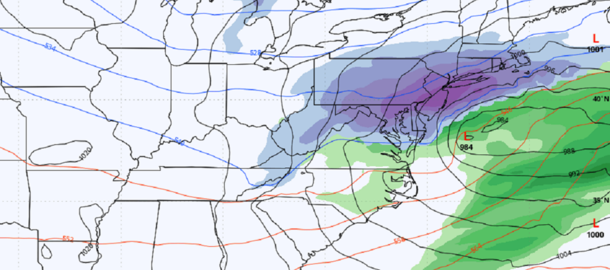
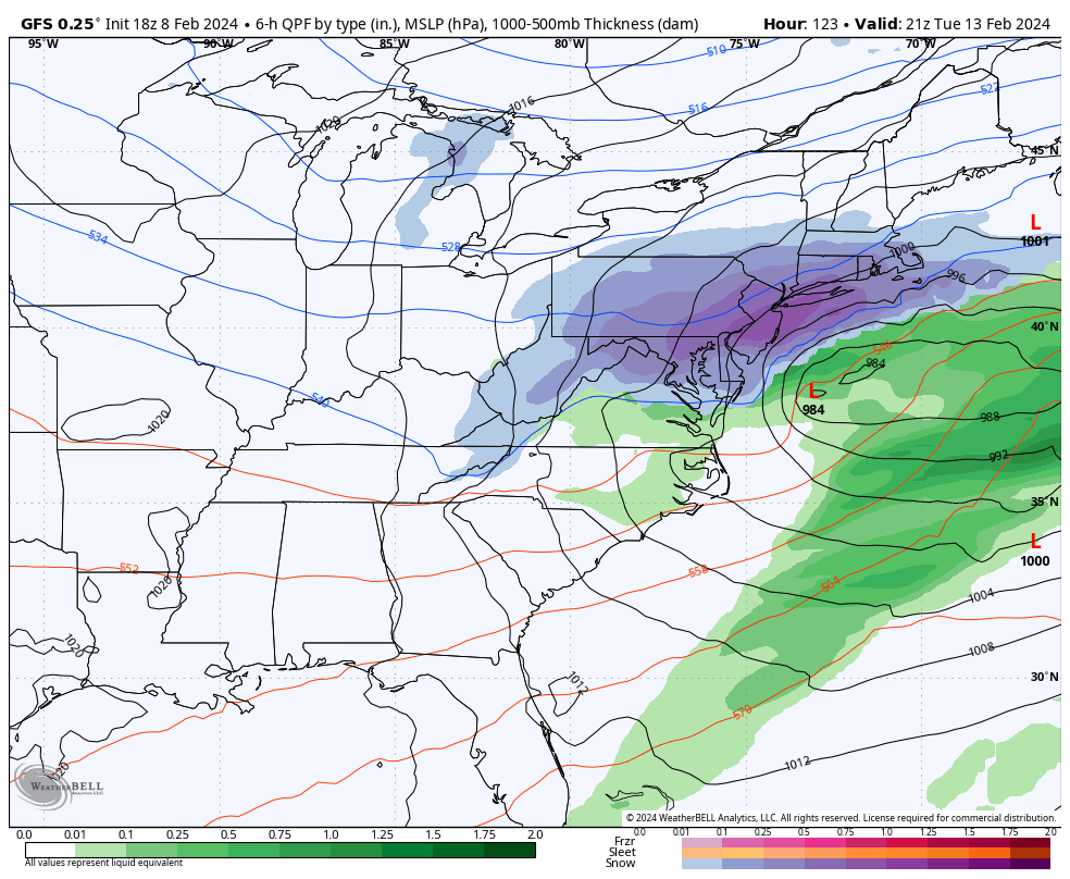
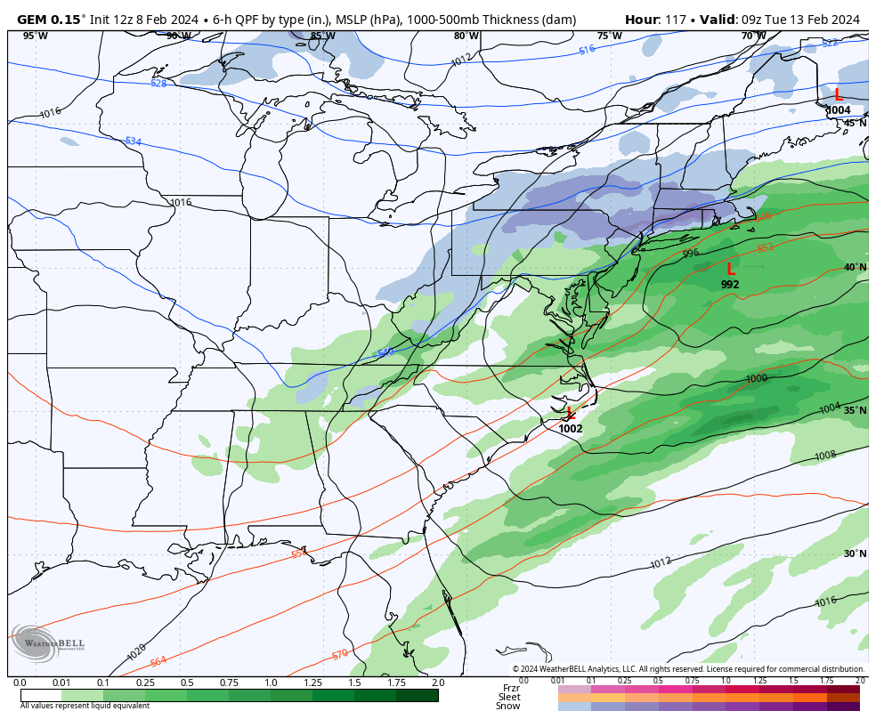
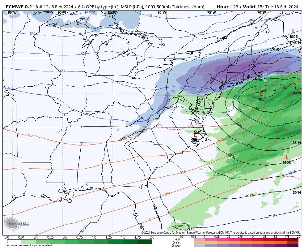
Between now and Tuesday, a southern stream piece of energy will track from the SW US across TX and then up towards OBX/Delmarva. A northern stream piece of energy will meet the southern piece and phase into a single area of cyclonic vorticity (a phase). The timing of these two pieces of energy will matter most for NJ’s outcome of snow vs rain vs nothing. If the N stream is too fast or early, then it will crush a system S of NJ for a miss. If the S stream is too quick and out ahead of the N stream, it will amp the system up into a New England blizzard at the expense of rain for NJ. However, if the two pieces of energy phase just right, it will produce an outcome like we’ve been seeing on the GFS. The Canadian and Euro have been a little N with their solutions but are now trending S towards the GFS solution. Here’s the latest spread in model guidance (the three bigs – GFS, Canadian, and Euro). The reason I like the GFS is not because it shows the most snow for NJ but because the Canadian and Euro, along with their ensemble members, have taken steps towards the GFS. Does that mean the GFS will be right? No it doesn’t. But it does mean that it could be handling the data better. For now, we ride…
We’re about 5 days out from this happening now (well within range to track seriously). However, I expect changes and trends to occur on model output over the next few days. This is common for a system that’s still considered “thread the needle.” These changes can be either exciting or heartbreaking depending on whether you love or hate snow. So don’t become too invested in a specific solution yet. But I am becoming more confident in at least some of NJ seeing a snowstorm this coming Tuesday.
I will continue to seriously track model guidance and look upstream at live observations for a few more days. This helps analyze whether certain model runs are initializing correctly, especially where the upstream energy originates for this potential winter storm…in the W US and Pacific. Saturday, at the earliest, would be our first detailed snow map and forecast. Until then, I will be tracking the increasing likelihood of NJ seeing a snowstorm this coming Tuesday. For a conservative approach on timing, let’s say this system can occur anytime between Monday night and Wednesday morning with Tuesday being the most likely day of highest impact. More to come.
In English: We’re mild the next few days and through this weekend. On Monday night we start getting colder. A snowstorm is then possible between Monday night and Wednesday morning with Tuesday likely featuring the wintriest impact of the system. It is too soon for specifics (exact rain to snow situation or snow/rain line situation through NJ). It could very well be a rain changing to snowstorm situation. We have a few days to iron this out. But for now, it feels like something wintry is going to happen early next week. Have a great night and please be safe! JC
Premium Services
KABOOM Club offers inside info forecast discussion, your questions answered, and early storm impact maps (ahead of the public). At a buck per month, it’s an extremely feasible way to show support.
My Pocket Meteorologist (MPM), in partnership with EPAWA Weather Consulting, offers professional/commercial interests, whose businesses depend on outdoor weather conditions (snow plowing, landscaping, construction, etc.), with hyper-local text message alerts/forecasts and access to the MPM premium forum—the most comprehensive and technical forecast discussion available for PA and NJ.
Get your KABOOM Inside Out pajamas and more at the KABOOM shop!
Jonathan Carr (JC) is the founder and sole operator of Weather NJ, New Jersey’s largest independent weather reporting agency. Since 2010, Jonathan has provided weather safety discussion and forecasting services for New Jersey and surrounding areas through the web and social media. Originally branded as Severe NJ Weather (before 2014), Weather NJ is proud to bring you accurate and responsible forecast discussion ahead of high-stakes weather scenarios that impact this great garden state of ours. All Weather. All New Jersey.™ Be safe! JC


LOCAL FORECAST | INTERACTIVE RADAR | LATEST NJ WEATHER ALERTS | WEDDING FORECAST| PRIVACY POLICY
© Copyright 2026 Weather NJ LLC. All Rights Reserved.
Some information that can be found on our website is provided by a private weather station and is not an officially recognized station for weather reporting. Though we always strive to achieve accurate reporting for our own use, it is important that you do NOT depend on the data provided here for any purpose.
