

Snowstorm Eyeing North Jersey Tuesday
Discussion: I want to re-emphasize a few points from my article two days ago. 1 – This Tuesday storm is not within the favorable snowstorm pattern that is developing. That begins right after this storm, and I still expect at least a few snow chances between now and the end of the snow season (including the rest of February—and into March). 2 – This storm is therefore still considered a thread-the-needle situation at the end of the current crappy pattern, and it has high volatility with what could happen this coming Tuesday. 3 – We are about 60 hours from this storm system happening. It’s still a little too far to be utilizing mesoscale model guidance (NAM, RGEM, HRRR, etc.). However we’re coming out of the specialty ranges of the global model guidance (GFS, GEM, EURO, etc.). The third and final point is that more changes are likely to be expected over the next 48 hours. But we are starting to see a picture come together.
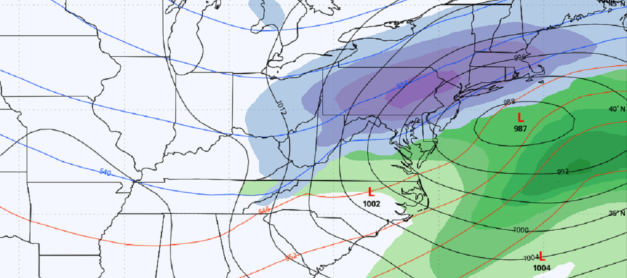
The energy is coming onshore, and the models are all going to need to adjust to the better sampled data. As we’ve seen with recent events, there are initial model over-corrections and then pull backs from model suite to model suite. Ultimately this means north and south shifts in the jackpot zone on model outputs. Today, there is undoubtedly a shift N that takes CNJ and SNJ out of the equation for big snow. It does, however, leave NNJ (I-78 and N) in the potential for big snow.
There are a few things I don’t like about this storm. I don’t like the surface temperature profile. It’s obviously very mild today and it will be mild Sunday and Monday ahead of the precipitation arriving late Monday night/early Tuesday morning. Temps will be allowed to fall a little Monday night after sundown. But the surface is going to need a lot of cold work to get cold enough to stick. This should happen along and N of I-78 where there is less rain expected but I’m not sure about areas S of I-78 in NJ. For areas S of I-78, the first half of the storm could be rain and the second half could be snow falling on an above-freezing surface…maybe slushing up on natural surfaces. If we had a better cold air injection, I would be more confident in surface temperatures crashing. But we instead have a stale cold air mass (ahead of the better pattern cold air mass) and I’m not sure it will do the trick S of I-78. For areas N of I-78 where heavy snow is expected to set up, it will likely lower the surface below 32F, especially for elevations.
So right now, I am becoming much less excited about SNJ, and even much of CNJ. I think this is leaning towards a NNJ storm. The following thoughts diagram represents where I currently stand…knowing that more changes either N or S are possible between now and tomorrow’s initial snow map and forecast. Let’s see what the next 24 hours of data suggests.
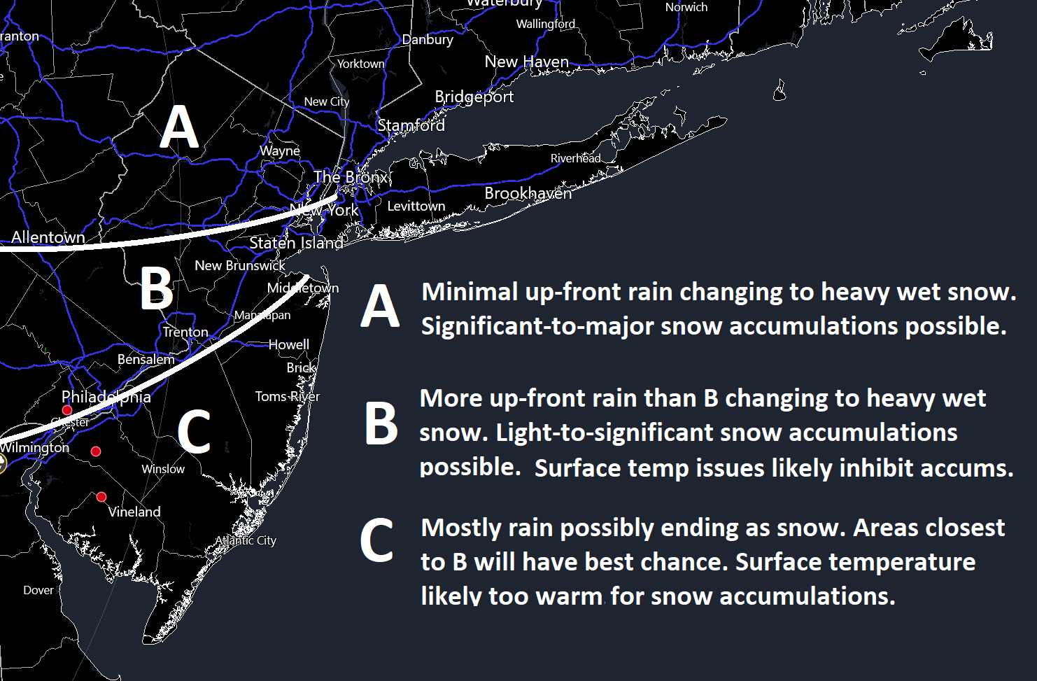
In English: Model guidance has trended north today. More changes are possible either north or south before our initial snow map and forecast tomorrow at 3pm. But for now, the above thoughts graphic represents where I’m at for this coming Tuesday after considering all data and live observations. I highly suggest reading the first paragraph so that everyone remains on the same page. Have a great rest of your Saturday and please be safe! JC
Premium Services
KABOOM Club offers inside info forecast discussion, your questions answered, and early storm impact maps (ahead of the public). At a buck per month, it’s an extremely feasible way to show support.
My Pocket Meteorologist (MPM), in partnership with EPAWA Weather Consulting, offers professional/commercial interests, whose businesses depend on outdoor weather conditions (snow plowing, landscaping, construction, etc.), with hyper-local text message alerts/forecasts and access to the MPM premium forum—the most comprehensive and technical forecast discussion available for PA and NJ.
Get your KABOOM Inside Out pajamas and more at the KABOOM shop!
Jonathan Carr (JC) is the founder and sole operator of Weather NJ, New Jersey’s largest independent weather reporting agency. Since 2010, Jonathan has provided weather safety discussion and forecasting services for New Jersey and surrounding areas through the web and social media. Originally branded as Severe NJ Weather (before 2014), Weather NJ is proud to bring you accurate and responsible forecast discussion ahead of high-stakes weather scenarios that impact this great garden state of ours. All Weather. All New Jersey.™ Be safe! JC


LOCAL FORECAST | INTERACTIVE RADAR | LATEST NJ WEATHER ALERTS | WEDDING FORECAST| PRIVACY POLICY
© Copyright 2026 Weather NJ LLC. All Rights Reserved.
Some information that can be found on our website is provided by a private weather station and is not an officially recognized station for weather reporting. Though we always strive to achieve accurate reporting for our own use, it is important that you do NOT depend on the data provided here for any purpose.
