

Snowstorm Signal Hunting
Discussion: This article is not a forecast. It’s a deep dive into the future physics of the atmosphere for the purposes of snowstorm signal hunting. If you’re looking for a quick “is it going to snow or is it not going to snow?” this article is not for you. If you are interested in the next time period when the pattern would be favorable for producing a snowstorm, welcome and enjoy!
First, we are now warming up in our January thaw. Overnight fog is a good piece of evidence that warm and moist air is moving into the region and meeting the existing overnight dew point temperature. I imagine this will happen again over the next few overnights until we reach our peak temperatures Friday and Saturday (in the 60s for some locations). Rain should move in between Friday night and Saturday morning, fall for most of Saturday before clearing out early Sunday AM ahead of a cold front passage. It’s one of those instances where the high temperature for the day will likely be reached Sunday morning with temperatures then falling throughout the day into a colder Sunday night. And that will conclude the January thaw period.
The first trough of colder air will move in Jan 11 and last until about Jan 14. A deeper and colder second trough then rebuilds in behind the first to give us a general window of synoptic storm signals from about Jan 15-20. A third trough then builds in behind that taking us to the end of most model guidance which goes out to about Jan 23. I am most focused, however, on the Jan 15-20 period when I believe two storm signals exist, one towards the front of that period and one towards the back of it. There is no way to pinpoint anything more beyond that but I can certainly talk about why I see the general signals.
The current warmth is being driven by a +EPO (Eastern Pacific Oscillation) which means a broad trough off the W US in the E Pacific Ocean. This forces warm air over the Pacific to round the bottom of the trough and spill across the US from W to E. It also forces a responding warm ridge over the E US which again, we are now dealing with. The +EPO spike is transient however and expected to build back to a -EPO by January 17. The PNA (Pacific North American) oscillation is also a measure of trough (+PNA) vs ridge (-PNA) but over the W US, not offshore of the W US in the E Pacific. Both a -EPO and +PNA usually work together when there is ridging between Alaska and California longitude. This combo is what forces a trough for the E US downstream. Based on the latest data, we should see a +PNA establish between ~Jan 11-17 and then the +EPO set up Jan 17-forward. With that said, expect the E US trough pattern to resume Jan 11-forward keeping the theme of below-average temperatures for this winter going strong after the transient warm Jan 6-11 break,
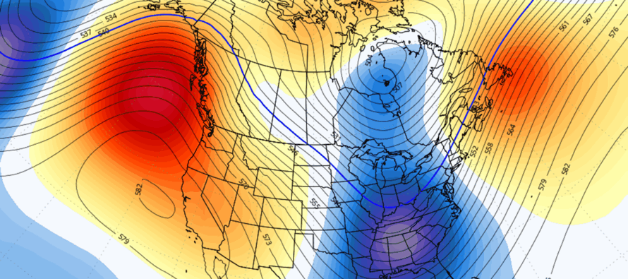
For my period of greatest interest (Jan 15-20), we’ll have the E Pacific/W US ridging forcing the E US trough pattern. Here are the global ensembles from the GFS, Canadian and Euro showing such:
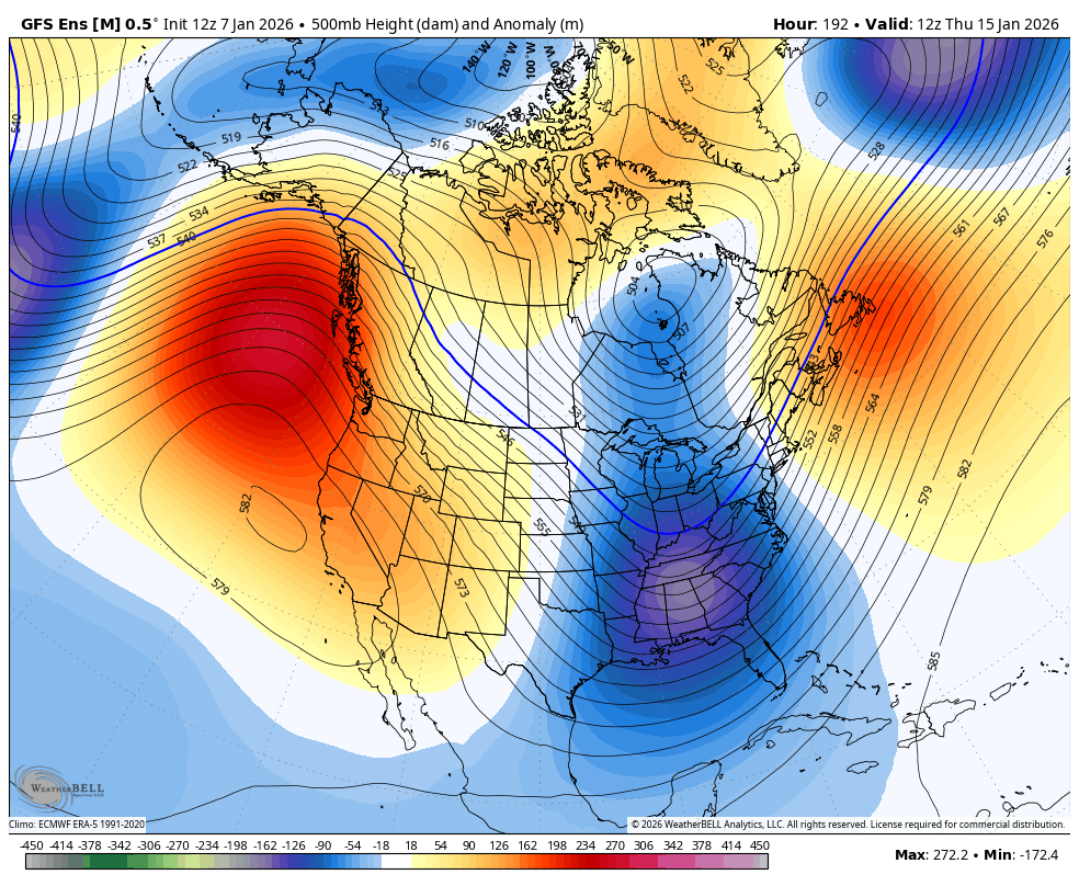
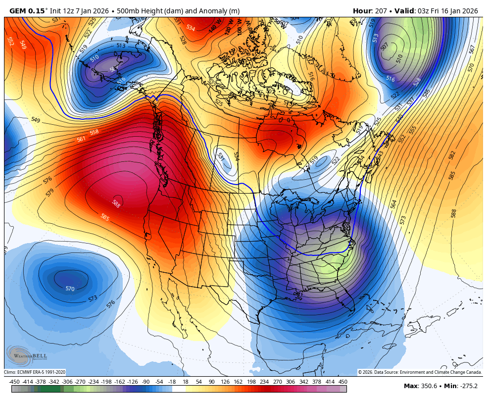
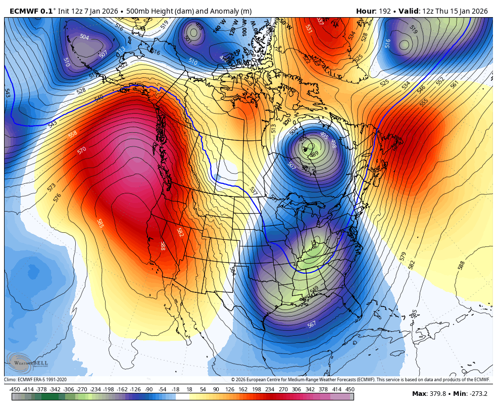
Whenever you have a deep E US trough like above, you’re going to have low pressure form on the front of the trough (lows – storms). Whether or not the low tracks too close or too far away…that’s a different animal that gets ironed out within generally a 5-day forecasting period. But from this range, we want to see the idea of W US ridging and E US troughing hold into this weekend. Then we can pass the baton of tracking from long-range pattern analysis to specific storm tracking. I imagine the models will start to checker their output (showing storms one run, no storm other runs, etc.), But I believe by this weekend (Jan 10-11) we will start to get an idea of what might happen snow-wise heading into the Jan 15-20 period that surrounds the following weekend. So if you are a weather nerd like me who likes to obsess about the future of the atmosphere with regard to potential snowstorms, the Jan 15-20 period is the next period to look to. No guarantees that a storm will happen. But that’s the next window where the pattern is capable of supporting snowstorm development for the east coast including New Jersey.
Looking beyond that window, the NAO (North Atlantic Oscillation) and AO (Arctic Oscillation) look to tank into the negative phases beyond Jan 17. NAO is a measure of ridge (-NAO) vs trough (+NAO) over Greenland. Snow lovers want a -NAO to slow storms down and produce more snow. AO is a measure of how tight (+AO) or loose (-AO) the polar jet bottles up the coldest air of the N Hemisphere near the N Pole. Snow lovers want a -AO to allow Arctic air to spill down and reinforce a colder snowstorm. If the -EPO holds through the rest of January then we’ll have an incredibly supportive pattern for snowstorm development. A -EPO or +PNA coupled with a -NAO and -AO is the magic combo pattern that has produced major greats in the past. Much of NJ is still above average snowfall for this time of season. I expect this to stay status quo come the end of January.
In English: We’re warm through early Sunday morning with Friday and Saturday the warmest days of the warmup where temps should range from 50s to 60s NNJ to SNJ. Expect rain between Friday night and Sunday morning (through most of Saturday). We then turn colder Sunday as a colder and more active storm pattern builds from Sunday through next Wednesday or Thursday (Jan 14-15). I am then looking at the Jan 15-20 period as our next period to watch for any snowstorms to form. Until about Jan 14 or so, we remain in a snowstorm break with some much needed rainfall for our reserves and aquifers. This is not a forecast for a specific snowstorm in the Jan 15-20 period, just acknowledgment of a pattern capable of supporting snowstorm development. It’s where I am currently hunting the next snowstorm. In the meantime, mind the fog possible the next few mornings until the cold returns. Have a great rest of your Wednesday and please be safe! JC
Premium Services
KABOOM Club offers an ad-free environment, inside info (Above and Beyond) forecast discussion, your questions prioritized, and early storm impact maps and video releases (ahead of the public). At $1.99 per month, it’s an extremely feasible way to show additional support for Weather NJ and you can turn it on and off for however many months you wish. Think of it as a tip jar with perks. Available onFacebook or Patreon.
My Pocket Meteorologist (MPM), in partnership with EPAWA Weather Consulting, offers professional/commercial interests, whose businesses depend on outdoor weather conditions (snow plowing, landscaping, construction, etc.), with hyper-local text message alerts/forecasts from real meteorologists and access to the MPM premium forum—the most comprehensive and technical forecast discussion available for PA and NJ commercial interests.
KABOOM Shop is live if you want some KABOOM or Weather NJ Merch!
Sign up for ZoneWatch Radar and get 10% off
Jonathan Carr (JC) is the founder and sole operator of Weather NJ, New Jersey’s largest independent weather reporting agency. Since 2010, Jonathan has provided weather safety discussion and forecasting services for New Jersey and surrounding areas through the web and social media. Originally branded as Severe NJ Weather (before 2014), Weather NJ is proud to bring you accurate and responsible forecast discussion ahead of high-stakes weather scenarios that impact this great garden state of ours. All Weather. All New Jersey.™ Be safe! JC


LOCAL FORECAST | INTERACTIVE RADAR | LATEST NJ WEATHER ALERTS | WEDDING FORECAST| PRIVACY POLICY
© Copyright 2026 Weather NJ LLC. All Rights Reserved.
Some information that can be found on our website is provided by a private weather station and is not an officially recognized station for weather reporting. Though we always strive to achieve accurate reporting for our own use, it is important that you do NOT depend on the data provided here for any purpose.
