

Southern NJ Digs Out. Watching Friday.
Discussion: As today’s SNJ system departs further into the Atlantic Ocean, another system is moving onshore in the NW US off the Pacific. Over the next 3 days, this energy should travel across the US and pick up energy from a southern branch in the SE US. This should produce another coastal low through the Mid-Atlantic US this late-Thursday night into Friday capable of delivering more snowfall.
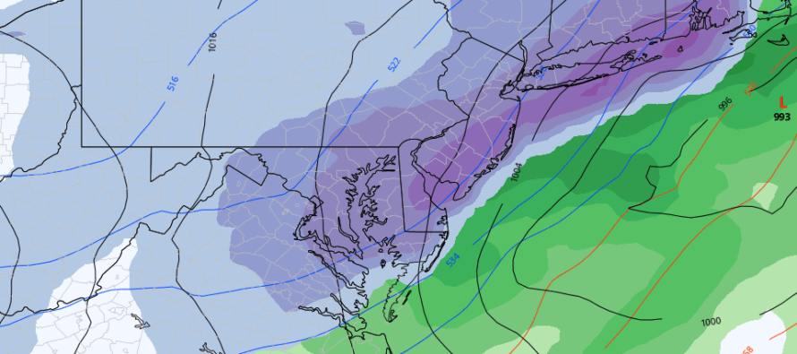
Originally this low was targeting areas NW of 95/NJTP only however the latest trend in model guidance is more of a statewide hit. We’re likely going to flop around on expected jackpot locations over the next few days but the meteorological principles are there for another snow storm impacting New Jersey.
We don’t have blocking to slow this system slow. The -NAO has temporarily left in the wake of the current system. Therefore, the snowfall is going to depend on the track and timing/coupling of energy. This one wants to eventually bomb for New England but for us, it will be a more immature developing low. There has to be enough interaction between the streams and the right timing to make it happen early enough for us. These are thing’s we’ll discuss over the next few days.
Current model guidance see these dynamics but disagree in trough orientation. The Canadian (pictured in the above image) and Euro (very similar to the Canadian) like the storm. The GFS is S and E…sheared out by a more positive trough axis flow. Some GFS ensemble members look more like the Euro and Canadian which tells me the operational GFS run might be an outlier. As you can see there are some things to work out. But the trough axis will determine if the system can wrap up in time for another NJ snowstorm or get sheared out. And that trough axis will be determined by the timing of N and S branch energy.
After this Jan 7 signal, the Jan 10-15 period is modeled for blocking to return (-NAO), a looser PV (-AO), and W US ridging (+PNA). This would in theory promote more winter storm possibilities for the Mid-Atlantic US.
In English: Tonight is obviously cold and that should be the theme through Tuesday into Wednesday AM. Wednesday PM into Thursday AM then looks milder with some rain sprinkles possible Wednesday afternoon. Temperatures should drop late Thursday PM into Friday as another potential snowstorm impacts New Jersey. Right now it looks more like all of NJ instead of NNJ or SNJ only. The maximum snowfall potential would likely be similar to today but it’s too soon for those details. We expect this to flop around. Over the next few days we will watch the evolution closely and report accordingly. Have a great week and please be safe! JC
Download the free Weather NJ mobile app on Apple or Android. It’s the easiest way to never miss Weather NJ content. Our premium services go even further above and beyond at the hyper-local level.
Jonathan Carr (JC) is the founder and sole operator of Weather NJ, New Jersey’s largest independent weather reporting agency. Since 2010, Jonathan has provided weather safety discussion and forecasting services for New Jersey and surrounding areas through the web and social media. Originally branded as Severe NJ Weather (before 2014), Weather NJ is proud to bring you accurate and responsible forecast discussion ahead of high-stakes weather scenarios that impact this great garden state of ours. All Weather. All New Jersey.™ Be safe! JC


LOCAL FORECAST | INTERACTIVE RADAR | LATEST NJ WEATHER ALERTS | WEDDING FORECAST| PRIVACY POLICY
© Copyright 2026 Weather NJ LLC. All Rights Reserved.
Some information that can be found on our website is provided by a private weather station and is not an officially recognized station for weather reporting. Though we always strive to achieve accurate reporting for our own use, it is important that you do NOT depend on the data provided here for any purpose.
