

Still Watching Monday for Snow
Discussion: The chances for snow in New Jersey on Monday continue to increase. I’ve been interested in this synoptic signal for some time now, specifically the modeled teleconnections (NAO, AO, and PNA). The NAO and AO are modeled to sharply transition from negative to positive on Jan 3-4 and the PNA is expected to back off extremely negative to near neutral. For me, this all still adds up to “something wintry” passing through the Mid-Atlantic US in the January 3 time frame.
It doesn’t look like a blockbuster/historical setup. It’s not like we have a strong block over Greenland, an Arctic spill of cold air, a ridge in the W US, and a hemorrhaging deep negative-tilting trough for the E US. But we do have the slightly favorable tellies and a trough that is now modeled more neutral than positive. Therefore, we have a “thread the needle in a crappy pattern” possibility that refuses to back off model guidance. The GFS did it’s typical “lose the storm system in the day 5-7 period” then has since reengaged with last night and today. I realize this data populates most of your daily weather apps and jukes the daily model huggers out of the water. But sometimes, key/critical upstream energy involved with a system passes over low sensor density areas of the world (especially the W Pacific) and then reappears over a higher sensor density areas. This is why storms can show at 7 days, ghost for a few days, then reappear day 4-5. That’s why it’s best to casually monitor storm signals in the long-range and not take every model run verbatim.
We’re still expecting a mild and wet New Years weekend with a flat and zonal pattern. A series of low pressure systems are expected to pass through. It looks like 3 as of now. The first two are warm and wet for NJ and should happen between this Friday and Sunday. After the second wave (Sunday), temperatures are expected to crash cold enough at all levels to support snow, especially once the trough moves in Monday morning. The trough, as I said before, is looking more neutral with more cyclonic vorticity wrapped up. There’s a pretty mean upper-level jet streak that could aid with divergence and difluence especially in the area of greatest positive vorticity advection…which is looking like the central Mid-Atlantic US.
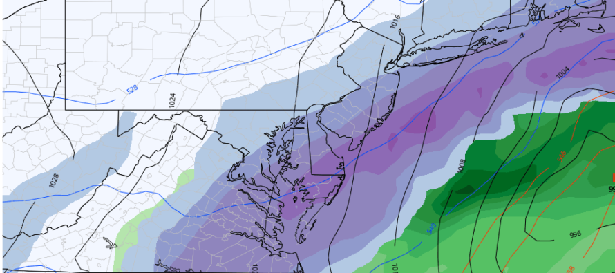
The best snow is currently favoring areas SE of I-95 (above image is from the latest GFS) but we have a few days to dial in the expected jackpot (highest snow accums of the system). I will now be monitoring and likely posting daily about this system leading into Monday. Saturday would probably be the first official snow map forecast with detailed probability discussion tomorrow. I told you a few days ago that I would be back today if this thing was still showing. Well here I am.
In English: After a mild and wet (at times) weekend, New Jersey is looking at it’s first snow system of the winter season this Monday. It is currently targeting SENJ with the most snow and it should be cold enough to support snowfall and accumulation. It’s not a major snow storm but possibly a plowable event. No coastal flooding or wind worries, likely just snow. I’ll check in tomorrow afternoon (Friday) once the daytime model data completes. Everyone have a great rest of your Thursday evening and please be safe! JC
Download the free Weather NJ mobile app on Apple or Android. It’s the easiest way to never miss Weather NJ content. Our premium services go even further above and beyond at the hyper-local level.
Jonathan Carr (JC) is the founder and sole operator of Weather NJ, New Jersey’s largest independent weather reporting agency. Since 2010, Jonathan has provided weather safety discussion and forecasting services for New Jersey and surrounding areas through the web and social media. Originally branded as Severe NJ Weather (before 2014), Weather NJ is proud to bring you accurate and responsible forecast discussion ahead of high-stakes weather scenarios that impact this great garden state of ours. All Weather. All New Jersey.™ Be safe! JC


LOCAL FORECAST | INTERACTIVE RADAR | LATEST NJ WEATHER ALERTS | WEDDING FORECAST| PRIVACY POLICY
© Copyright 2026 Weather NJ LLC. All Rights Reserved.
Some information that can be found on our website is provided by a private weather station and is not an officially recognized station for weather reporting. Though we always strive to achieve accurate reporting for our own use, it is important that you do NOT depend on the data provided here for any purpose.
