

Storm Front Approaching
Discussion: The warm front is well through and you should now be feeling the ripping warm sector out of the S/SW.
As a quick refresher, the Norwegian Cyclone Model is the standard meteorological model for synoptic-scale mid-latitude cyclones, like the one currently centered over the Great Lakes tracking into SE Canada. Like-wise temperatures collect into air masses like fan blades circling the center of the low cyclonically (counterclockwise in our N Hemisphere). Warm and muggy air mass is ripped out of the S/SW ahead of the low. The leading edge of this air mass is the warm front and the warm sector is the air mass itself behind the warm front. Cold air is gathered and drawn in out of the NW on the W side of the low. This cold sector is the colder and dryer air we feel behind the leading edge of this colder air mass, the cold front. To the N of the cyclone is an easterly fetch from typically the maritime air masses so ocean temperatures factor into such big time. It’s all trying to spiral drain into he low as the low tracks generally from SW to NE. But yeah, we’re currently in the warm sector feeding a 977mb low now just N of Lake Huron. That’s why the winds are gusting out of the S/SW.
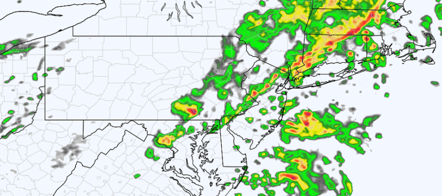
The main storm front of interest has tracked across W PA and is just now through the State College, PA area. Everything that happens before that should be limited to rain and 30-45mph S/SW wind gusts. It looks like SENJ is most favored for the rain between now and storm front time. The storm front itself is what could feature the higher wind gusts to 60mph. These winds will be generated by downward-driven gust fronts and the lowering of the strong lower-level jet. While these could be the highest winds of the day, some might miss them. Given the convective nature, it could be more of a scattered wind threat along the storm front. But basically, the synoptic-scale S/SW winds will remain gusty right up until the storm front passes through your areas. And the storm front will either be a wind finale or a sudden drop off depending on which localized areas see the strongest storms.
It is hard to estimate the timing of the storm front. From the hip, it approaches NWNJ around 7-8pm, pushes through the I-95 corridor between 7-10pm and finishes along SENJ by midnight or just after. The actual length of impact should be about 30-45 minutes. The general expected idea are stronger storms for NWNJ and WNJ than SENJ/ENJ. Diurnal surface heating will be lost with sundown and marine influence will likely help stabilize the coast some. That’s not to say that ENJ/SENJ can’t still see a solid punch. But again, the best dynamics are in PA/WNJ.
Given the dynamics, you can’t rule out a tornado. There’s decent shear, and both up and down drafting to stand horizontal rotation upwards. It’s not a strong chance but it’s a small non-zero chance. Only way to get ahead of that is to monitor couplets on velocity in real-time and immediately predict eastward paths.
Once the cold front is well through (by sunrise Friday), we should stabilize and dry for the weekend. Expect highs in the 55-62/lows in the 35-42 range (NNJ to SNJ) for Friday through Sunday. It looks dry, with mixed skies, but not as warm as I wish it could be. It should still feel a lot better than the recent high in the 30s/lows in the teens and 20s crap. Especially in the afternoon sun.
In English: Winds are now ripping out of the S/SW and they will continue to do so until a main storm front pushes through later this evening. Rainfall is possible between now and the main event with SENJ having the best chance for it. The storm front could contain the highest winds of the day in a scattered nature (some could miss). Should approach NWNJ by 7-8pm and clear SENJ by midnight or just after. The storm front is capable of producing heavy downpours, gusty/damaging winds, a good chance of lightning, and a small chance of a tornado. NWNJ/WNJ sees it the hardest with weakening expected for ENJ/SENJ. A relatively mild (but still cool) weekend is then on tap with dry and mixed skies.
A reminder, if you haven’t seen previous mentions, that the mobile application is down for now. I was paying an app service (basically drag and drop create your app) and it was not working out. I plan to develop my own app and release it in time for this coming winter. I apologize for this inconvenience. All weather content will be posted to the main web site and linked to from social sites. Be safe! JC
Premium Services
KABOOM Club is more for the snow lover or weather nerd who needs inside info with early forecast discussion and storm impact maps (ahead of the public). It’s a bit more complex than what the public sees but offers the “In English” with it. It’s also a way to support Weather NJ with a 99-cent per month contribution.
My Pocket Meteorologist offers commercial interests, whose businesses depend on outdoor weather conditions (snow plowing, landscaping, construction, etc.), with hyper-local text message forecasts and access to the My Pocket Meteorologist premium forum. This information is the most complex analysis available as needed by the outdoor commercial sector.
Jonathan Carr (JC) is the founder and sole operator of Weather NJ, New Jersey’s largest independent weather reporting agency. Since 2010, Jonathan has provided weather safety discussion and forecasting services for New Jersey and surrounding areas through the web and social media. Originally branded as Severe NJ Weather (before 2014), Weather NJ is proud to bring you accurate and responsible forecast discussion ahead of high-stakes weather scenarios that impact this great garden state of ours. All Weather. All New Jersey.™ Be safe! JC


LOCAL FORECAST | INTERACTIVE RADAR | LATEST NJ WEATHER ALERTS | WEDDING FORECAST| PRIVACY POLICY
© Copyright 2026 Weather NJ LLC. All Rights Reserved.
Some information that can be found on our website is provided by a private weather station and is not an officially recognized station for weather reporting. Though we always strive to achieve accurate reporting for our own use, it is important that you do NOT depend on the data provided here for any purpose.
