

Storm Recap and Next Snow Chance
Discussion: Running a little slow today as I stayed up way too late for a neighborhood walk in the heavy snow. As a snow lover at heart, it was well worth it, but boy do I need the coffee today!
There were only a few small areas that fell short of our minimum 2” expectation we had statewide. One was the Brick/Toms River region of Ocean County/S Monmouth and points west from there. This area fell most victim to the subsidence (sinking air) created by the freak monster band (lifting air) to its N. Not only does sinking air dry the surface layer, it warms it in response to the lowering dew point temperature. This is why ECNJ/SENJ coastal regions stayed above 32F until about 3am when heavier precip eventually overrode the surface with cold. But certainly a few inches lost up-front there. There were some other checkered areas in SNJ that saw some dry slotting which kept the surface a little warmer to start. Also, extreme NNJ areas saw subsidence on the N side of the freak band but higher snow ratios got most NNJ areas close to 2. Other than that, most NJ locations got to at least 2 inches. Most paved surfaces and roads for CNJ/SNJ avoided accumulation, especially treated roads. Natural/cold surfaces (grass/trees/parked cars/etc.) were much friendlier to snow accumulation.
At around 11pm it became evident that a mesoscale convective snow band was forming from about Harrisburg, PA, through Reading/Southern Lehigh into Hunterdon County NJ and across to NYC (along and just N/S of I-78). This was an area where 700mb frontogenesis was screaming under a raging 250mb jet streak. Reminded me of the Dec 2013 band that got the Eagles game. Snowfall rates in this band were 3-4 inches per hour (higher-ratio) and it parked as a deformation band over the same area for 2-3 hours. The HRRR model had this band drifting in latitude for a wider-spread impact of 3-5/4-6 across more of NNJ/CNJ. No guidance nor live obs had it parking in place for 2-3 hours until it did. Such an occurrence is a mesoscale occurrence that can only be identified as it forms in real-time. Would you believe that there were 3 KABOOMS this winter? One early January (NNJ), one last week (NNJ), and another last night for a very small area that defines the NNJ/CNJ divider near I-78. Last night’s freak monster band will be as meteorologically historical as that Dec 2013 band.
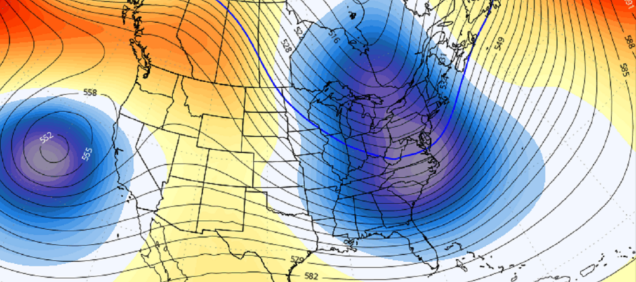
Today we warmed but we’ll drop below freezing statewide tonight. Scattered lake-enhanced snow showers are possible today through tonight with the strong flow over the Great Lakes towards New Jersey but little-to-no accumulation is expected. This could present a melt/re-freeze scenario so be careful if traveling/walking on sidewalks/etc. Tomorrow through at least mid-week, we’re seasonably chilly (not cold) but mundane…afternoon highs in the low-to-mid 40s, overnight lows near/just below freezing, and a mix of sun and clouds. But this next weekend period (Feb 23-25) is another storm signal that I’ll be watching closely. It’s been on and off of surface model guidance the last few days but the upper-levels look pretty good as depicted below.
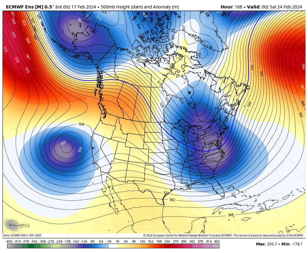
If the Feb 23-25 storm signal is going to happen, the surface signals should start converging on a consensus between now and Monday or Tuesday of this coming week. Otherwise, that could be it for winter snow outside of a few thread-the-needle opportunities into March.
In English: The storm has cleared out to sea after verifying most most of our NJ forecast less a few areas skimped and one area KABOOMED (N and S of I-78-ish). Lake-effect snow showers could still push through today/tonight from the NW in and on-and-off manner. Little-to-no accumulation are expected with these. Otherwise we are seasonably chilly/slightly-above average temps and boring tomorrow through most of this coming week. Watching Feb 23-25 storm signal for more snow. Should have more to report about it by Monday/Tuesday. Casually watching data until then. Have a great rest of your weekend and please be safe! JC
Premium Services
KABOOM Club offers inside info forecast discussion, your questions answered, and early storm impact maps (ahead of the public). At a buck per month, it’s an extremely feasible way to show support.
My Pocket Meteorologist (MPM), in partnership with EPAWA Weather Consulting, offers professional/commercial interests, whose businesses depend on outdoor weather conditions (snow plowing, landscaping, construction, etc.), with hyper-local text message alerts/forecasts and access to the MPM premium forum—the most comprehensive and technical forecast discussion available for PA and NJ.
Get your KABOOM Inside Out pajamas and more at the KABOOM shop!
Jonathan Carr (JC) is the founder and sole operator of Weather NJ, New Jersey’s largest independent weather reporting agency. Since 2010, Jonathan has provided weather safety discussion and forecasting services for New Jersey and surrounding areas through the web and social media. Originally branded as Severe NJ Weather (before 2014), Weather NJ is proud to bring you accurate and responsible forecast discussion ahead of high-stakes weather scenarios that impact this great garden state of ours. All Weather. All New Jersey.™ Be safe! JC


LOCAL FORECAST | INTERACTIVE RADAR | LATEST NJ WEATHER ALERTS | WEDDING FORECAST| PRIVACY POLICY
© Copyright 2026 Weather NJ LLC. All Rights Reserved.
Some information that can be found on our website is provided by a private weather station and is not an officially recognized station for weather reporting. Though we always strive to achieve accurate reporting for our own use, it is important that you do NOT depend on the data provided here for any purpose.
