

Storm System to hit Friday PM-Saturday AM
Discussion: Another storm system will push through NJ between Friday and Saturday with mostly wet impacts to most of the state. The only area that could see a wintry mix IMO is N of I-80 and NW of I-287…basically Sussex, N Warren, N Passaic. And we’re only talking about a coating to an inch or two at most in the highest elevations. S Warren and S Passaic likely mixing too much to accumulate anything. Therefore all areas along and S of I-80 or SE of I-287 will see rain as the dominant precipitation type.
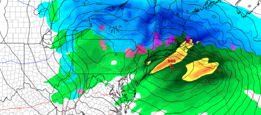
The low is currently over Texas and just getting going. It will track into the S Great Lakes between now and Friday afternoon/evening. This is when rain will first arrive likely for SWNJ first. The low will then change direction and head towards SNJ. As this happens rain will push further into NJ with a snow/ice/rain line setting up somewhere near I-80 by later Friday night through Saturday morning. All precipitation will clear once the low pushes out to sea and colder air will move into NJ from behind.
I think the wind will be the most remembered feature of this system especially for coastal areas. Winds should pick up Friday evening out of the SE and howl into Saturday. For most of NJ, away from the ocean, expect sustained winds of 10-20mph with gusts to 40mph. For coastal regions (ECNJ and SENJ), expect sustained winds of 20-30mph with gusts to 45-50mph possible. There might be room for a few 60mph gusts if things align right but likely at least 45-50mph gusts along the coast. Winds should gradually subside from Saturday AM through PM hours with a calmer situation by late Saturday night/Sunday morning.
Flash flooding is possible from rainfall across the region, especially closer to Philadelphia along the Delaware River in areas of poor drainage. Coastal flooding is also possible from the onshore SE wind component. The SENJ coast could see minor, possibly moderate, coastal flooding during Saturday AM hours (3-4am). The ECNJ coast could see slightly higher levels with more of a moderate shot of coastal flooding, especially in the Raritan Bay area where the SE flow could dam up the water better.
This system represents the last storm of the crappier snow pattern (-PNA + Phase 7 MJO). After this, a favorable pattern for wintry storm development is still expected to open starting March 8 or so. This will last until maybe the equinox or shortly after. Then it will be time for spring with snow likely in our rear-view mirror until the 2023-2024 snow season. But in that March 8 to March 22 window, there will be a few systems worth watching that are capable of bringing snow to NJ.
In English: A storm system will move through NJ between Friday afternoon/evening and Saturday morning. Expect mostly rain except for extreme NNJ/NWNJ where a coating to an inch or two of snow accumulation is possible from a wintry mix. Expect winds to pick up and become gusty, possibly damaging along the ECNJ/SENJ coast Friday night through Saturday morning. Less damaging away from the ocean and moreso just gusty. Coastal flooding is possible, likely minor possibly moderate, along the ECNJ/SENJ coasts. I’ll update in tomorrow’s weekend outlook which will be just before the first drops move into SWNJ from the SW. Still watching the middle of March for some final potential wintry impacts. Will be ready to dive in after this approaching system. Have a great rest of your Thursday and please be safe! JC
Premium Services
KABOOM Club offers inside info forecast discussion, your questions answered, and early storm impact maps (ahead of the public). At 99 cents per month, it’s an extremely feasible way to show support.
My Pocket Meteorologist (MPM), in partnership with EPAWA Weather Consulting, offers professional/commercial interests, whose businesses depend on outdoor weather conditions (snow plowing, landscaping, construction, etc.), with hyper-local text message alerts/forecasts and access to the MPM premium forum—the most comprehensive and technical forecast discussion available for PA and NJ.
Jonathan Carr (JC) is the founder and sole operator of Weather NJ, New Jersey’s largest independent weather reporting agency. Since 2010, Jonathan has provided weather safety discussion and forecasting services for New Jersey and surrounding areas through the web and social media. Originally branded as Severe NJ Weather (before 2014), Weather NJ is proud to bring you accurate and responsible forecast discussion ahead of high-stakes weather scenarios that impact this great garden state of ours. All Weather. All New Jersey.™ Be safe! JC


LOCAL FORECAST | INTERACTIVE RADAR | LATEST NJ WEATHER ALERTS | WEDDING FORECAST| PRIVACY POLICY
© Copyright 2025 Weather NJ LLC. All Rights Reserved.
Some information that can be found on our website is provided by a private weather station and is not an officially recognized station for weather reporting. Though we always strive to achieve accurate reporting for our own use, it is important that you do NOT depend on the data provided here for any purpose.
