


Storm Update

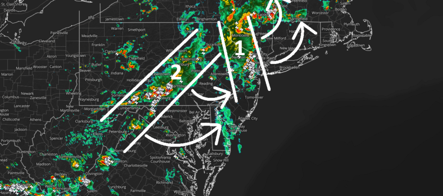
Discussion: We are looking at two parts to the main event that are already underway for NNJ (currently 3:50pm). These parts are attached to the low and will rotate through NJ as I have them illustrated in the above cover image (radar imagery used with permission from ZoneWatch Pro). Both parts have the capability to produce flash floods and severe winds.
Part 1 is into NNJ and will rotate out to the NE over the next several hours. But right now it’s slapping NNJ up pretty good. Part 2 will rotate to impact all of NJ. This will be the slowest rotating cluster of rain and thunderstorms and should rotate through NJ between about 7/8pm until just after midnight. This entire system should clear NJ by 2/3am Wednesday morning with little-to-no rain afterwards for the rest of Wednesday. So far, downpours, lightning and winds are common. I am casually watching for any wind damage/rotation associated with the low circulation against the mid-upper-level flows. So far so good but must continue to be watched for possible tornado development.
Thursday and Friday could still feature some light drizzle/rain/breeze out of the N or NW. This is because the low is very slow-moving, especially with the upper low tugging on it. Therefore, it will take time to move far enough out to sea to shut off NJ rain completely. Saturday and Sunday still look like an improvement.
In English: Downpours and thunderstorms are well into NNJ (as of 3:50pm) in the first round of today’s main rain/storm event. This first part (marked as 1 on the above image) should rotate out of NNJ/CNJ by about 5-6pm. Part 2 will then rotate through all of NJ (including SNJ) between about 7/8pm and 2/3am. Many locations will receive 2-3 inches of rainfall, some possibly higher for localized instances. It has become clear that NNJ will see more rain than SNJ when all is said and done. But a much-needed soaker for NJ in general. Will report accordingly on any damaging wind scenarios. Be safe! JC
Premium Services
KABOOM Club offers an ad-free environment, inside info (Above and Beyond) forecast discussion, your questions prioritized, and early storm impact maps and video releases (ahead of the public). At $1.99 per month, it’s an extremely feasible way to show additional support for Weather NJ and you can turn it on and off for however many months you wish. Think of it as a tip jar with perks. Available onFacebook or Patreon.
My Pocket Meteorologist (MPM), in partnership with EPAWA Weather Consulting, offers professional/commercial interests, whose businesses depend on outdoor weather conditions (snow plowing, landscaping, construction, etc.), with hyper-local text message alerts/forecasts from real meteorologists and access to the MPM premium forum—the most comprehensive and technical forecast discussion available for PA and NJ commercial interests.
KABOOM Shop is live if you want some KABOOM or Weather NJ Merch!

Jonathan Carr (JC) is the founder and sole operator of Weather NJ, New Jersey’s largest independent weather reporting agency. Since 2010, Jonathan has provided weather safety discussion and forecasting services for New Jersey and surrounding areas through the web and social media. Originally branded as Severe NJ Weather (before 2014), Weather NJ is proud to bring you accurate and responsible forecast discussion ahead of high-stakes weather scenarios that impact this great garden state of ours. All Weather. All New Jersey.™ Be safe! JC



LOCAL FORECAST | INTERACTIVE RADAR | LATEST NJ WEATHER ALERTS | WEDDING FORECAST| PRIVACY POLICY
© Copyright 2026 Weather NJ LLC. All Rights Reserved.
Some information that can be found on our website is provided by a private weather station and is not an officially recognized station for weather reporting. Though we always strive to achieve accurate reporting for our own use, it is important that you do NOT depend on the data provided here for any purpose.

