Stormfront Approaching. Ian to hit US.

Discussion: I’m going to cover two topics today. First will be the approaching frontal system with immediate impacts to NJ this evening/tomorrow morning…and what that will set up for much of this week. Then we’ll cover Ian.
Rain and thunderstorms are currently pushing into WNJ from our W. Most storm cells are non-severe and should remain this way however I wouldn’t rule out isolated instances of severe winds being met, especially in SNJ. Otherwise, these rain/storm cells are riding another approaching cold front that is attached to low pressure tracking through the lakes…in the wake of Fiona’s trough capture.
Today we’re seeing warmer temperatures and higher humidity associated with the immediate warm sector ahead of this front. I would expect isolated-to-scattered showers and thunderstorms to continue rotating through NJ for the rest of today and possibly into some of Monday AM hours. Once that is through, we’ll be in another refreshing fall air mass for the rest of Monday through possibly Friday. We’re talking highs in the 60s/70s with lows in the 40s/50s with mostly dry conditions and low humidity.
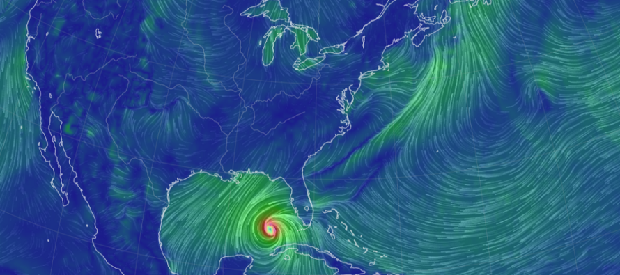
Ok, now let’s talk Ian. Ian initially juked us all out as Hermine formed just before it off W Africa earlier this weekend. Ian was originally expected to be named Hermine. But now that we’re beyond that, Ian is a tropical storm in the middle of the Caribbean Sea. Ian is now entering a low-shear high water temp environment and we should now see it further strengthen into a hurricane as it tracks from its current location towards W Cuba over the next 24-36 hours.
Once Ian passes over W Cuba (around Tuesday morning), it will then take aim at the NW quadrant of the Gulf of Mexico. There’s still a decent amount of uncertainty as to the exact landfall location in the Wednesday night to Friday morning time window. A blend of most model guidance indicates anywhere from Panama City, FL to Tampa, FL with Florida’s Big Bend area splitting the middle of the guidance. I expect the models to go back and forth, spraying between these general area/cone of uncertainty. Regarding intensity, Ian is expected to reach a major category hurricane once N of W Cuba/W of S FL. The NHC is suggesting Ian weakening back to a non-major category hurricane before landfall but let’s see how it plays out. The gulf is very warm.
After W FL landfall, Ian will obviously weaken over SE US land and likely transition to an extratropical cyclone as it gains latitude up the E US. That means, the destructive synoptic wind component will phase out and give way to just a broad cyclonic system of rain and mostly just moderate winds. The wildcard would be if any tornadoes spawn up in the NW quadrant of circulation as that area shears against the mid-latitude westerlies. This is something we’ll have to watch for as Ian’s remnants travel from the NW gulf coast, up through the SE US, and then ultimately out over the ocean somewhere near the Mid-Atlantic US. We (NJ) will have a corresponding area of high pressure that will play at least some form of blocking role for Ian. With that said, Ian’s remnants could slide out to sea just to NJ’s S or possibly right over. Going to have to re-evaluate this once Ian is N of W Cuba on Tuesday. That will determine what Ian will do for NJ in the Friday-Sunday period (Sept 30-Oct 2).
In English: A storm front is pushing through NJ right now. Most storms are below severe criteria and most action should stay this way. If anyone is going to see severe thunderstorms, SNJ has a better chance. Expect scattered showers/downpours to push through for the rest of this evening, possibly into early Monday morning. Today was warmer and muggier but tonight we’ll return to a cooler pattern that should last most of this week (at least Mon-Fri). We’re talking afternoon highs in the 60s/70s and overnight lows in the 40s/50s all with lower humidity. Some real good open windows weather. Chances are then increasing that Ian’s remnants will pass over New Jersey in the Friday-Sunday period of this coming weekend (Sept 30-Oct 2)…mostly in the form of much needed rain but possibly with moderate winds. I’ll be tracking this closely. Please enjoy the rest of your Sunday and be safe! JC
Premium Services
KABOOM Club offers inside info forecast discussion, your questions answered, and early storm impact maps (ahead of the public). At a buck per month, it’s an extremely feasible way to show support.
My Pocket Meteorologist (MPM), in partnership with EPAWA Weather Consulting, offers professional/commercial interests, whose businesses depend on outdoor weather conditions (snow plowing, landscaping, construction, etc.), with hyper-local text message alerts/forecasts and access to the MPM premium forum—the most comprehensive and technical forecast discussion available for PA and NJ.
Jonathan Carr (JC) is the founder and sole operator of Weather NJ, New Jersey’s largest independent weather reporting agency. Since 2010, Jonathan has provided weather safety and forecasting services for New Jersey and immediate surrounding areas through the web and social media. Originally branded as Severe NJ Weather (before 2014), Weather NJ is proud to bring you accurate and responsible discussions ahead of high-stakes weather scenarios that impact the garden state. All Weather. All New Jersey.™


