


Stormy Period Detected

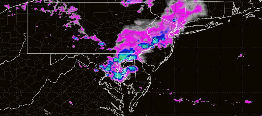
Discussion: This week into Labor Day Weekend looks interesting to me. It could be our most storm-potent Ring of Fire pattern this entire year. And for that reason, we are in daily article mode rather than the traditional weekly outlook. Let’s review a little:
A Ring of Fire pattern is when a ridge sets up to the W of NJ (over the Central US/S of the Great Lakes). This pattern indicates that the upper jet (observed at 250mb) is moving Up, over and down across the US. It aligns NJ with a W/NW flow from the Great Lakes into NJ. Since the upper jet is the train track for storm energy to travel along, NJ then becomes subject to Mesoscale Convective Systems (MCS) moving in from the W/NW. This next image illustrates the mechanism when viewing 500mb height anomalies and upper steering currents:
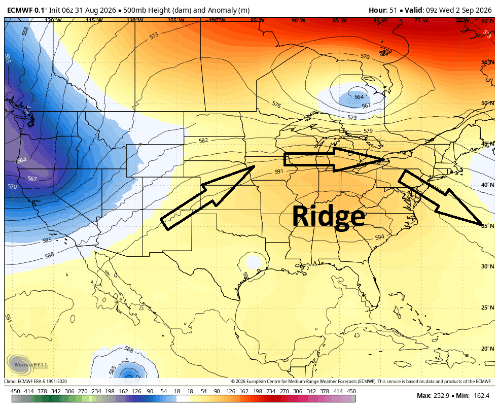
Also notice the Upper Low (UL) in Canada. This will help tighten the upper jet and enhance its speed (similar to a multiplexing mechanism) while also opening up on the other side of it near NJ. This opening up can lower pressure drops via divergence. And the increased jet speed can stretch the atmosphere, further lowering pressure drops vis difluence. Lastly, this upper jet can provide a venting mechanism which helps keep the inflow and updrafts separate from the downdrafts within storm cells. This ultimately allows the storm(s) to sustain their strength even to the coast rather than updrafts choking on their own downdrafts. It all adds up to a very potent environment for thunderstorm development during the Tuesday-Thursday period of this week in New Jersey.
The common general theme this week will be elevated humidity and rain showers capable of producing flash flooding. I believe most NJ areas will at least see that. This is due to a very moist tropical environment near and to the S of the main storm track with high Precipitable WATer (PWAT) value. Today (Monday) could feature some isolated shower and thunderstorm activity but likely run of mill downpours and rumbles with minimal damage potential. Tuesday, Wednesday and Thursday then look stormier with Wednesday likely the stormiest. Therefore, Wednesday has the best chance to stack wind damage potential on top of the rain and rumble expectation. But all three days (Tues, Wed and Thurs) could produce damaging wind gusts during thunderstorm hits.
Since this will be a track of multiple waves of energy, I would expect numerous rounds of thunderstorms moving through NJ from W/NW to E/SE in that Tues-Thurs period. You could see waves of storms every 6-12 hours honestly. Like I said, this should be our most active Ring of Fire setup this year…unlike some of the more inactive occurrences earlier this year. There is no way to pinpoint which specific hours the storms come through. They will be moving very fast once they get loaded into the steering currents. With that said, we will have to take each day by day on radar/live observations. From this point, all we can say is buckle up for Tues-Thurs and hold on tightest Wednesday.
Friday should be a transitional day as the upper jet sinks to the S of NJ. Can’t rule out a few isolated showers and storms as this happens. The upper jet will then rotate its axis around a trough backing in from the NE. So, instead of running W/NW to E/SE through NJ, it will run N/NW to S/SE to the SW of NJ. This will allow cooler and drier to spill down from Canada towards NJ from the N. The result at the surface would be cooler, drier and comfortable air mass for Labor Day Weekend. So that’s how LDW looks for now. I will have a more detailed outlook Thursday when the approaching stormy period is on its way out.
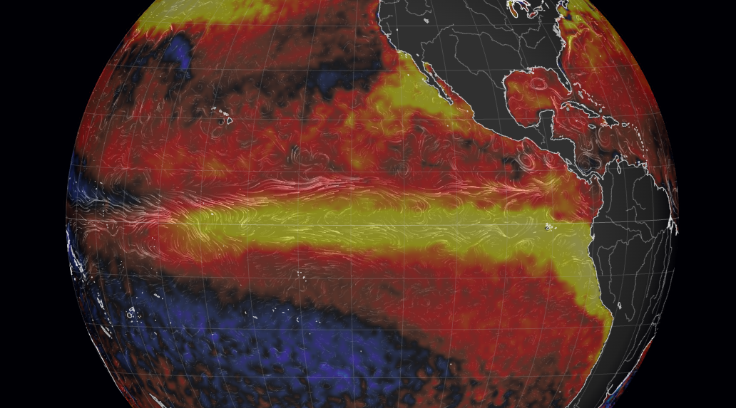
The tropics remain quiet for east coast interests despite increased Pacific and lower US latitude activity. This is concurrent with tropical expectations during a strong El Nino ENSO status. Dolly is shearing out prior to even making it to the Caribbean. There is currently a wave (Tropical Cyclone 5) that could become Eduardo just prior to TX/LA landfall (a fast sneak attack) but this would fizzle out well to the SW of NJ interests. Here’s a look at current sea surface temperature anomalies over the equatorial E Pacific. The warm anomalies reflect the current strong El Nino, stronger than how 2015-2016 and 1997-1998 presented. Could be a wild ride this fall/winter. As I said in prior articles, El Nino doesn’t mean no snow. It might mean an overall milder winter but specific active patterns within the winter can still produce large snowstorms (see Jan 2016):
In English: The humidity is back and will be with us through at least Friday morning/afternoon. Get ready for a week where rainfall amounts surprise, even from smaller showers, as we lock into a tropical air mass. That will make highs near-90 feel even hotter. As we all know though, we can use the rain and are almost out of drought status for most NJ locations. The upper jet is going to get involved in creating an environment rich for thunderstorm development, especially between this Tuesday and Thursday with Wednesday the most probable day for wind-related damage and power outages. But all three days (Tues, Wed and Thurs) could feature the same. Just iso stuff today (Monday) and Friday as the overall stormy pattern enters and exists. I will try my best to anticipate storm times at the beginning of each day. But we could see multiple rounds of fast-moving storms move through NJ (from W/NW to E/SE) every 6-12 hours. We’ll stay in daily article mode through this period. Once everything moves to the S and SW of NJ on Friday, then Friday night through most of Labor Day Weekend looks good. Highs in the 75-80 range with lower humidity and dry skies. Be safe! JC
Premium Services
KABOOM Club offers an ad-free environment, inside info (Above and Beyond) forecast discussion, your questions prioritized, and early storm impact maps and video releases (ahead of the public). At $1.99 per month, it’s an extremely feasible way to show additional support for Weather NJ and you can turn it on and off for however many months you wish. Think of it as a tip jar with perks. Available on Facebook or Patreon.
My Pocket Meteorologist (MPM), in partnership with EPAWA Weather Consulting, offers professional/commercial interests, whose businesses depend on outdoor weather conditions (snow plowing, landscaping, construction, etc.), with hyper-local text message alerts/forecasts from real meteorologists and access to the MPM premium forum—the most comprehensive and technical forecast discussion available for PA and NJ commercial interests.
KABOOM Shop is live if you want some KABOOM or Weather NJ Merch!

Jonathan Carr (JC) is the founder and sole operator of Weather NJ, New Jersey’s largest independent weather reporting agency. Since 2010, Jonathan has provided weather safety discussion and forecasting services for New Jersey and surrounding areas through the web and social media. Originally branded as Severe NJ Weather (before 2014), Weather NJ is proud to bring you accurate and responsible forecast discussion ahead of high-stakes weather scenarios that impact this great garden state of ours. All Weather. All New Jersey.™ Be safe! JC



LOCAL FORECAST | INTERACTIVE RADAR | LATEST NJ WEATHER ALERTS | WEDDING FORECAST| PRIVACY POLICY
© Copyright 2026 Weather NJ LLC. All Rights Reserved.
Some information that can be found on our website is provided by a private weather station and is not an officially recognized station for weather reporting. Though we always strive to achieve accurate reporting for our own use, it is important that you do NOT depend on the data provided here for any purpose.

