

Stormy Start (June 19-23)

Monday’s thunderstorm threat has the headline this week. Let’s break it down…
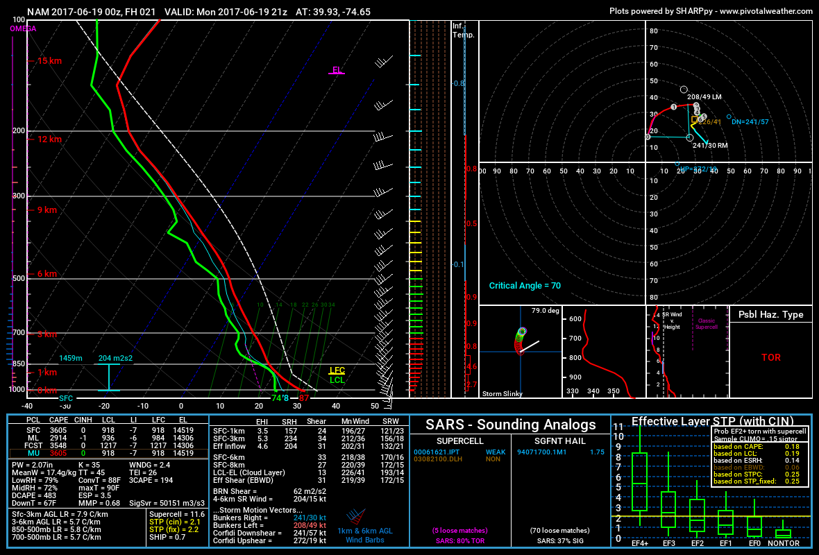
Discussion: The severe thunderstorm threat remains firmly in place for Monday as a cold front is expected to plow through this haunting humid air mass. We have more than adequate instability given the well-timed diurnal heating cycle. We also have sufficient wind shear given the strong mid-level W/SW jet atop a strong surface S jet. That should generate horizontal roll in at least a few spots. If those rolling air masses pass over a strong enough updraft then they could stand up into a tornado. This would be more likely if the cells have a supercell signature coming out of PA/MD (not linearly attached to each other). On the contrary, if thunderstorm activity forms into linear segments then straight line wind damage would be the better bet. Either way, severe winds are possible with the stormy frontal passage tomorrow afternoon/evening. I’ll be chasing and updating live. For those who understand thermodynamic skews/soundings, this is off of the latest 00Z NAM run…
The rest of the week looks rather uneventful aside from seasonal pop-up cells. We should at least see a small period of humidity relief Tuesday-Wednesday after the cold front is through but not total relief. By Thursday, humidity and warmer temperatures should trickle back in with more southerly flow. The weekend looks like garbage right now with a few low pressure systems traversing a draped frontal boundary over our region. Let’s see if that can improve this week as model guidance evolves.
Monday (June 19) high temperatures should reach the low-to-mid 80s statewide. Skies should be muggy and tropical-like during the day, especially for sunny spots. The main period for possibly severe thunderstorms is 5-8PM statewide from W to E (NWNJ first SENJ last). Isolated storm activity is possible both before and after that period. The I-95 corridor and points NW have the best potential for severe criteria. SENJ has the best chance for fizzling energy but no one should let their guard down with this kind of setup.Winds should be breezy, even gusty at times, out of the S. Obviously winds could become gusty near/under any active thunderstorm cells. Overnight lows should fall into the 60s statewide as storm activity subsides with the departing front.
Tuesday (June 20) high temperatures should reach the low-to-mid 80s. Skies could start mixed with elevated remnant humidity in the morning but should give way to a drier feel by afternoon. NWNJ should feel drier than SENJ. Winds should be light out of the W/SW. Overnight lows should fall into the 60s statewide.
Wednesday (June 21) high temperatures should struggle to break 80 statewide. Skies should be partly-to-mostly sunny with a few isolated showers/t-storms floating around. Winds should be light out of the W. Overnight lows should fall into the 60s for most and possibly even the 50s away from the ocean and up in the NNJ elevations.
Thursday (June 22) high temperatures should reach the low-to-mid 80s statewide. This should conclude the small relief from humidity. Skies should be partly sunny and dank with isolated showers/t-storms floating around. Winds should be light-to-breezy out of the SW. Overnight lows should fall into the 60s statewide.
Friday (June 23) high temperatures could break 90 away from the ocean. NNJ elevations and coastal areas should likely hang in the low-to-mid 80s. Skies should be partly sunny and humid with showers and thunderstorms possible, especially during afternoon-evening hours.
An early look at the weekend sucks. It just sucks. Let’s hope the current rainy/stormy look disappears on mid-range model guidance this week. Let’s take another look in a few days. I took the above picture a few years ago in Maryland. It best represents how I think tomorrow afternoon/evening will look for many. Have a great week and please be safe! JC
Jonathan Carr (JC) is the founder and sole operator of Weather NJ, New Jersey’s largest independent weather reporting agency. Since 2010, Jonathan has provided weather safety discussion and forecasting services for New Jersey and surrounding areas through the web and social media. Originally branded as Severe NJ Weather (before 2014), Weather NJ is proud to bring you accurate and responsible forecast discussion ahead of high-stakes weather scenarios that impact this great garden state of ours. All Weather. All New Jersey.™ Be safe! JC


LOCAL FORECAST | INTERACTIVE RADAR | LATEST NJ WEATHER ALERTS | WEDDING FORECAST| PRIVACY POLICY
© Copyright 2026 Weather NJ LLC. All Rights Reserved.
Some information that can be found on our website is provided by a private weather station and is not an officially recognized station for weather reporting. Though we always strive to achieve accurate reporting for our own use, it is important that you do NOT depend on the data provided here for any purpose.

)