

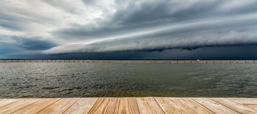
Stormy Start. Settled Finish
Discussion: Tuesday through this weekend is a much more settled forecast expectation. We’re colder than average due to a trough dominating the region, however we are mostly dry for the rest of this week. I am seeing some rain Friday and then later in the weekend but it’s garden variety spring showers not a severe outbreak. So the rest of this discussion will center on today (Monday) and the severe potential through this evening.
First, the overall system and cold front are moving faster than most guidance has indicated leading up to today. That means most rain and storms should push through this evening, not early Tuesday AM. The cold front itself might wait until Tuesday morning to push through, but the potential severe conditions riding the front of the cold front should come through this evening. Second, there is more rain and storm energy focused in the warm sector with a pre-frontal trough this afternoon/evening rather than along the cold front later tonight. With that said, I expect a heavier rain with embedded thunderstorms to push into NJ from the S/SW between about 2-3pm today (Monday). Should be a solid dumping from about 2-3pm until about 6-7pm. During this time, we have some nasty shear in the atmosphere capable of producing anything from severe straight-line winds to EF0-EF1 tornadoes. The NWS has placed much of NJ in a tornado watch until 7pm for this reason. Then a lull is expected from about 7pm until about midnight until the cold front moves through. While the afternoon rain will be more of a prolonged rainy/stormy period, tonight’s cold front should push a thin 5-15 minute period of linear downpours/thunderstorms through. The tornado and high wind threat ends when the cold front pushes through. You’ll know this when winds switch from S/SE to W/NW. The NWS might extend their tornado watch later beyond 7pm this evening to also include the cold frontal passage. But if not, just know it could be very windy into the overnight, not just until 7pm. The main reason we have the tornado threat is because of S warm sector flow conflicting with cyclonic flow around the low. This generates solid wind shear and an environment for twisters to spin up. After midnight, once the cold front is through, elevated areas like the Poconos and NWNJ elevations could see ending precipitation mix wintry but with little-to-no accumulation before precip tapers off for all areas by 2-3am. So get ready for a stormy windy late-afternoon through this evening. The 2-3pm to 7-8pm stuff should be the most severe period, not the cold frontal passage much later tonight/overnight. Just keep The bottom line is if we can get through this afternoon/evening’s storm/high wind potential, the rest of the week looks much more settled.
Forecast
Monday (March 16) high temperatures should reach the mid-to-upper 60s for most NJ areas, mid-50s along the ECNJ/SENJ immediate coasts. Skies should be mixed with sun, clouds and rain showers during the day. Strong-to-severe thunderstorms are possible between afternoon-evening hours with high winds likely and tornadoes possible. Winds should be breezy-to-gusty out of the S with intensity picking up until the overnight cold front. Overnight lows should fall back into the 30s, especially towards Tuesday sunrise once the cold front is through.
Tuesday (March 17) high temperatures should reach the 39-43 range for most NJ locations. Skies should gradually improve from mostly cloudy in the morning to mostly clear by late-afternoon. Winds should be their strongest during early AM hours out of the S/SE before changing to just breezy out of the W/NW. Winds should subside into overnight hours.
Wednesday (March 18) high temperatures should reach near-40 for most NJ locations. Some areas might not escape the upper-30s (elevations, coasties, etc.). Skies should start with a mix of sun and clouds but transition to mostly cloudy by afternoon/evening. Winds should be light out of the SW. Overnight lows should fall to the 25-33 range NNJ-SNJ.
Thursday (March 19) high temperatures should reach near-50 for most NJ locations. Skies should be mixed with sun and clouds. Winds should be light out of the S/SE. Overnight lows should fall back into the 30s (above freezing) for most NJ locations.
Friday (March 20) high temperatures should range from 50-60 NNJ to SNJ away from the ocean. Closer to 50 for immediate coasties. Skies should be mixed with sun and clouds with a few showers pushing through later in the evening/overnight. Winds should be light out of the S/SW. Overnight lows should range from mid-30s to mid-40s NNJ to SNJ.
An early look at the weekend (March 21-22) indicates another milder day for Saturday with temps well into the 50s possibly breaking 60 in some locations. Sunday looks a little cooler with some rain showers around. We should then turn slightly colder to start the following week before bouncing back to near-average the rest of the following week. No synoptic snowstorm signals are showing at this time which means there’s a good chance the snow season is over. Have to give it until last day of March though. Have a great week and please be safe! JC
Premium Services
KABOOM Club offers an ad-free environment, inside info (Above and Beyond) forecast discussion, your questions prioritized, and early storm impact maps and video releases (ahead of the public). At $1.99 per month, it’s an extremely feasible way to show additional support for Weather NJ and you can turn it on and off for however many months you wish. Think of it as a tip jar with perks. Available onFacebook or Patreon.
My Pocket Meteorologist (MPM), in partnership with EPAWA Weather Consulting, offers professional/commercial interests, whose businesses depend on outdoor weather conditions (snow plowing, landscaping, construction, etc.), with hyper-local text message alerts/forecasts from real meteorologists and access to the MPM premium forum—the most comprehensive and technical forecast discussion available for PA and NJ commercial interests.
KABOOM Shop is live if you want some KABOOM or Weather NJ Merch!
Jonathan Carr (JC) is the founder and sole operator of Weather NJ, New Jersey’s largest independent weather reporting agency. Since 2010, Jonathan has provided weather safety discussion and forecasting services for New Jersey and surrounding areas through the web and social media. Originally branded as Severe NJ Weather (before 2014), Weather NJ is proud to bring you accurate and responsible forecast discussion ahead of high-stakes weather scenarios that impact this great garden state of ours. All Weather. All New Jersey.™ Be safe! JC


LOCAL FORECAST | INTERACTIVE RADAR | LATEST NJ WEATHER ALERTS | WEDDING FORECAST| PRIVACY POLICY
© Copyright 2026 Weather NJ LLC. All Rights Reserved.
Some information that can be found on our website is provided by a private weather station and is not an officially recognized station for weather reporting. Though we always strive to achieve accurate reporting for our own use, it is important that you do NOT depend on the data provided here for any purpose.
