

Strong New Jersey Storm Expected
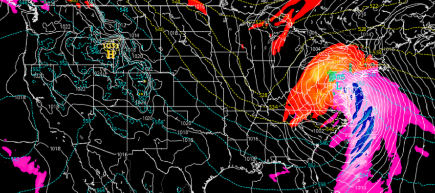
Discussion: This upcoming Sunday PM-Monday AM event is not a pure snowstorm. It will contain some wintry aspects to it (upfront snow…possibly ending as snow for some) but the meat and potatoes of it are a strong synoptic-scale rain and wind storm IMO. We will have a deepening surface low (strong upper level dynamics) tracking up the E US either along or just inside the east coast and that should bring a mixed bag of weather conditions. Therefore, let’s break the impacts down individually.
Snow
Snow should break out for areas along and NW of the turnpike/95 corridor any time after sundown Sunday evening. Areas SE of the turnpike will likely start as rain or immediately changeover from a wintry mix to rain. This should establish a snow rain line near the turnpike that will gradually push N/NW between Sunday night and early Monday morning. NWNJ elevations (extreme NNJ/NWNJ) will be the last to changeover and therefore have the best chance to see the most amount of snow fall and accumulate before changing over. By early Monday morning I expect even NWNJ to change over to at least a wintry mix. With all of this said, a period of sleet is possible along the snow/rain line as it advances northward. And sleet might mix in further N keeping snow accumulations down some prior to the changeover. Like I said, this is not a pure snow storm. The following snow impact map represents our thoughts on snow but only represent our lowest concerns of the system:
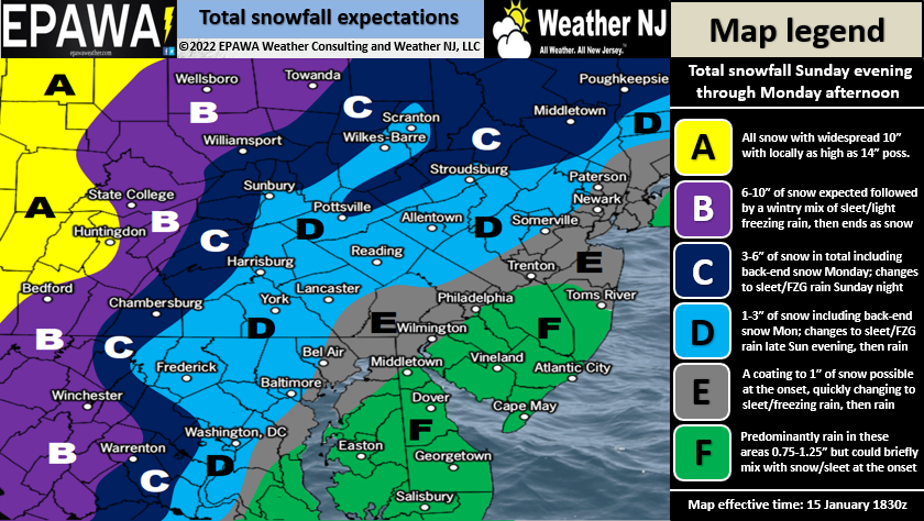
Full resolution snow impact map.
Rain
Rain is straightforward and simple. About 1-2 inches total should fall between the 8 hour general window of sunset Sunday to Sunrise Monday. Nothing crazy but still a decent amount of liquid relative to the time period.
Wind
Wind is my primary concern for NJ. We’re looking at a peak 3-4 hour wind period somewhere within the general window of 8PM Sunday to 4AM Monday. Areas of NJ away from the ocean (most of the state) should expect sustained winds of 15-25mph with gusts up to 50mph possible. Areas right along the immediate ECNJ/SENJ coast should expect sustained winds of 25-40mph with gusts up to 65mph possible. It would not surprise me to see a few isolated 70mph gusts along the immediate barrier islands/coasts. Winds will be onshore (out of the E/SE) during the windiest period then switch to W/NW once the center of the low passes through NJ (from S/SW to N/NE). Winds should then continue to howl for the rest of Monday but gradually subside by Monday night.
Temperature
The temperature change profile with this system is kind of nuts. Today is obviously cold and tonight will be colder with overnight lows ranging from single digits to teens from N to S. On Sunday morning, winds will become onshore and take most of ECNJ/SENJ above freezing by late morning. The ~turnpike/95 corridor should rise above freezing by afternoon and ultimately NNJ (even NWNJ) by early Monday morning. On Monday temps should peak in the 40s statewide, possibly 50s for SENJ, before everyone drops back below freezing again Monday night into Tuesday morning. So basically we are cold, then warm for the storm, then cold again right after the storm. It’s hard to believe that it will be raining above freezing Sunday night after being so close to zero for many Sunday morning…but trust me it will.
Flooding
I was much more concerned about flooding earlier this week but it looks like timing will be a saving grace for the Jersey shore. The peak wind-driven storm surge should occur during low tide for ECNJ/SENJ. This would be late Sunday night/early Monday morning. Therefore tidal flooding should be held to just minor/moderate levels, not major. The next high tide occurs later Monday morning when winds will be blowing offshore, not onshore. Whew! It could have been bad. For locations further N along the east coast (Long Island Sound and New England), it’s going to be bad there as high tide will time with the peak wind-driven storm surge. Some of the tidal guidance I am seeing for those areas are just bonkers…10 feet above MLLW. But for New Jersey, I think the coast will only deal with run-of-mill flooding not historical.
In English: A strong storm will impact NJ between Sunday evening and Monday morning. It looks much wintrier for NWNJ than for SENJ. Everyone should eventually change over to rain including NWNJ (but last). The above snow map represents how much snow we think will fall. Otherwise, NJ should expect a period of heavy rain and gusty winds (especially the coast) in that period. The above discussion breaks each impact out individually. I’ll check back in tomorrow one last time before live storm observations begin tomorrow night. Have a great rest of your Saturday and please be safe! JC
Download the free Weather NJ mobile app on Apple or Android. It’s the easiest way to never miss Weather NJ content. Our premium services go even further above and beyond at the hyper-local level.
Jonathan Carr (JC) is the founder and sole operator of Weather NJ, New Jersey’s largest independent weather reporting agency. Since 2010, Jonathan has provided weather safety discussion and forecasting services for New Jersey and surrounding areas through the web and social media. Originally branded as Severe NJ Weather (before 2014), Weather NJ is proud to bring you accurate and responsible forecast discussion ahead of high-stakes weather scenarios that impact this great garden state of ours. All Weather. All New Jersey.™ Be safe! JC


LOCAL FORECAST | INTERACTIVE RADAR | LATEST NJ WEATHER ALERTS | WEDDING FORECAST| PRIVACY POLICY
© Copyright 2026 Weather NJ LLC. All Rights Reserved.
Some information that can be found on our website is provided by a private weather station and is not an officially recognized station for weather reporting. Though we always strive to achieve accurate reporting for our own use, it is important that you do NOT depend on the data provided here for any purpose.
