

Strong Storm Approaching New Jersey
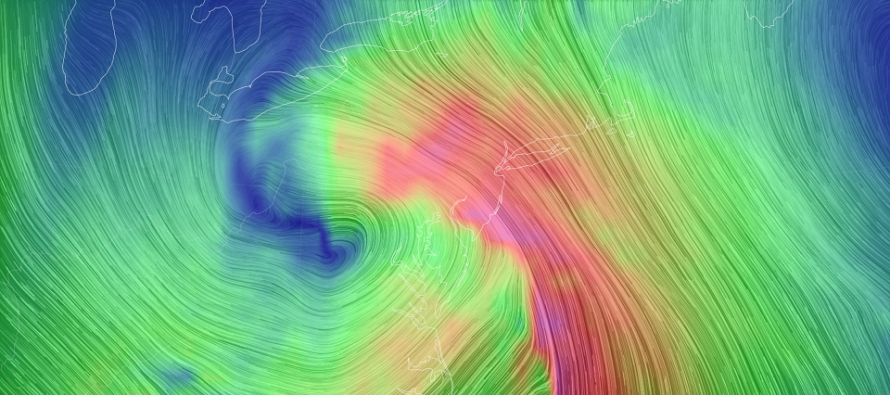
Discussion: Earlier this week, a short wave dropped into the N US and dove to Texas to form a closed-off upper-level low (ULL). This ULL drifted E a bit, through the SE US, before interacting with another upper wave, that later dove into the N US, and turned the ULL up the E US coast. Since the upper-level air currents ultimately steer surface disturbances, we now have a surface low tracking up the E US (inside the immediate east coast) and likely to the W of NJ due to negative-axis upper-level flow to the SW of NJ. The surface low itself should then jump E and move out but not before hurling in a vicious warm flow off the ocean for about a 6-hour period. The above image represents the 850mb suggested flow later tonight from the GFS model. Basically the trailing wave DDTed the ULL up the E US. This thing is so yoinked back and up, that the cold front will move in with S/SW flow tomorrow morning.
There are no changes to our snow map or general forecast ideas. This looks like a snow to ice to rain scenario along/NW of the turnpike/95 corridor. Areas along and SE of the turnpike will likely start as rain or quickly go over to it. NWNJ, especially elevations, should see the most amount of snow before changing to ice or rain and therefore see the snow jackpot of the snow map/area. For areas of NNJ/NWNJ that do see a nice front-end snow thump, the changeover could produce quite the sloppy situation IMO. Not enough rain to wash the snow away but enough to make it slushy. Here’s our snow map again for reference:
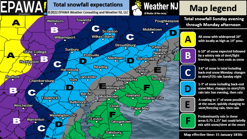
Full resolution snow/ice/rain impact map.
Winds are going to howl and likely not just for the coast. The coast will take the worst of it to the face but high winds look to reach across NJ into PA. It should easily gust to 50mph+ away from the ocean and possibly up to 70mph right along the immediate coast. Sustained winds probably 15-25mph away from the ocean and 25-40mph right along it. Expect a 3-5 hour period of peak winds to slide up the E US (from S to N) tonight through tomorrow morning. Cape May starts first and ends first (~sunset tonight to ~midnight). Sandy Hook starts last and ends last (~midnight tonight to ~sunrise tomorrow)…and so forth across the state northward. Everything should be out of here by daylight hours tomorrow. Again, these winds should reach across NJ/Philly into EPA so expect possible power outages and downed trees across most of NJ, not just along the coast.
The coastal flooding situation still looks okay for most of the Jersey Shore due to peak wind surge timing well with tonight’s low astronomical tide. For these reasons, coastal flooding should be held to the minor category for at least the southern 90% of the Jersey Shore. For the sake of safety and awareness, let’s assume that it could possibly reach moderate levels just because of the full moon and draining rain. But I do not think major flooding is likely anywhere from Sandy Hook down through Cape May. The Raritan Bay area though is geologically formed to collect more of the surge up into the lower Hudson area. I could see higher levels of coastal flooding there. But from Sandy Hook and northward (including the Raritan/Hudson Bay area) up the coast (Long Island Sound, Cape Cod, etc.) has the best chance for major coastal flooding as the peak surge will be more timed with high tide. And since it’s a 6-hour or less period of onshore flow, it should only really affect one tidal cycle. Tomorrow’s high tide is around noon or after when winds will be blowing offshore and actually setting up a blowout low tide scenario for the next day or two.
In English: A strong storm system is approaching New Jersey. I’m seeing the first sign of precip approach SWNJ now. NWNJ looks the most wintry before changing over to ice or rain. SENJ looks the warmest and will see little-to-no accumulations of snow. Everyone between should see snow change to rain quicker than NWNJ. But don’t get me wrong, a solid snow thump is possible along and NW of the turnpike. You might even see some decent snowfall just SE of the turnpike but the surface is warming and will continue to warm. The above map represents our snow/ice/rain thoughts but our primary concern is wind. High winds will likely cause power outages, downed trees, etc. Coastal flooding less of an issue for ocean-facing Jersey shore due to the strongest winds occurring at low tide. Coastal flooding is more of an issue for Raritan/Hudson Bays and points northward along the east coast tomorrow morning. This is not a pure snow strong storm but it IS a strong storm. It’s going to crank tonight through tomorrow morning. I can’t stress enough that small human beings should be secured. Everything should be out of here by daylight tomorrow and we’ll just deal with colder W/NW winds. Then we can start talking about the strong weekend winter storm signal (Jan 22-23). We have plenty of time. Let’s get through this storm tonight first. Be safe! JC
Download the free Weather NJ mobile app on Apple or Android. It’s the easiest way to never miss Weather NJ content. Our premium services go even further above and beyond at the hyper-local level.
Jonathan Carr (JC) is the founder and sole operator of Weather NJ, New Jersey’s largest independent weather reporting agency. Since 2010, Jonathan has provided weather safety discussion and forecasting services for New Jersey and surrounding areas through the web and social media. Originally branded as Severe NJ Weather (before 2014), Weather NJ is proud to bring you accurate and responsible forecast discussion ahead of high-stakes weather scenarios that impact this great garden state of ours. All Weather. All New Jersey.™ Be safe! JC


LOCAL FORECAST | INTERACTIVE RADAR | LATEST NJ WEATHER ALERTS | WEDDING FORECAST| PRIVACY POLICY
© Copyright 2026 Weather NJ LLC. All Rights Reserved.
Some information that can be found on our website is provided by a private weather station and is not an officially recognized station for weather reporting. Though we always strive to achieve accurate reporting for our own use, it is important that you do NOT depend on the data provided here for any purpose.
