

Strong Storm/Arctic Front Developing
Discussion: Right now (today – Wednesday) we have positive height anomalies overhead of the US east coast. This is because the SE Atlantic Ridge was allowed to build for the E US due to the upstream +PNA ridge being a little too far W (just into the Pacific rather than over the W US). In between these ridges, a very cold trough is still expected to form and impact NJ with several safety hazards. A strong low will occlude off the jet over the lakes and work with a strong Arctic high in the NW US to pull down a piece of the Tropospheric Polar Vortex (TPV) between. Then as the high dives southward through the W US then eastward towards the SE US while the low stays over the lakes, the TPV Arctic air mass will bend down and around towards New Jersey. This will be a massive size storm with wind impacts radiating outwards to cover almost 2/3 of the E US (while low remains near lakes). Let’s break it down:
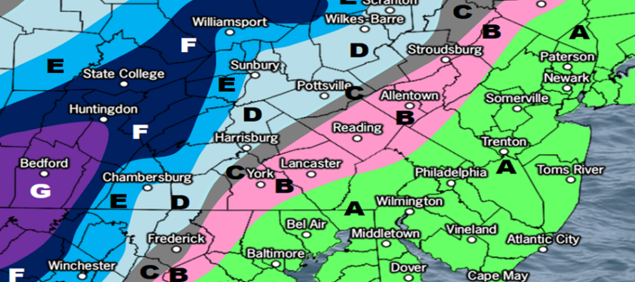
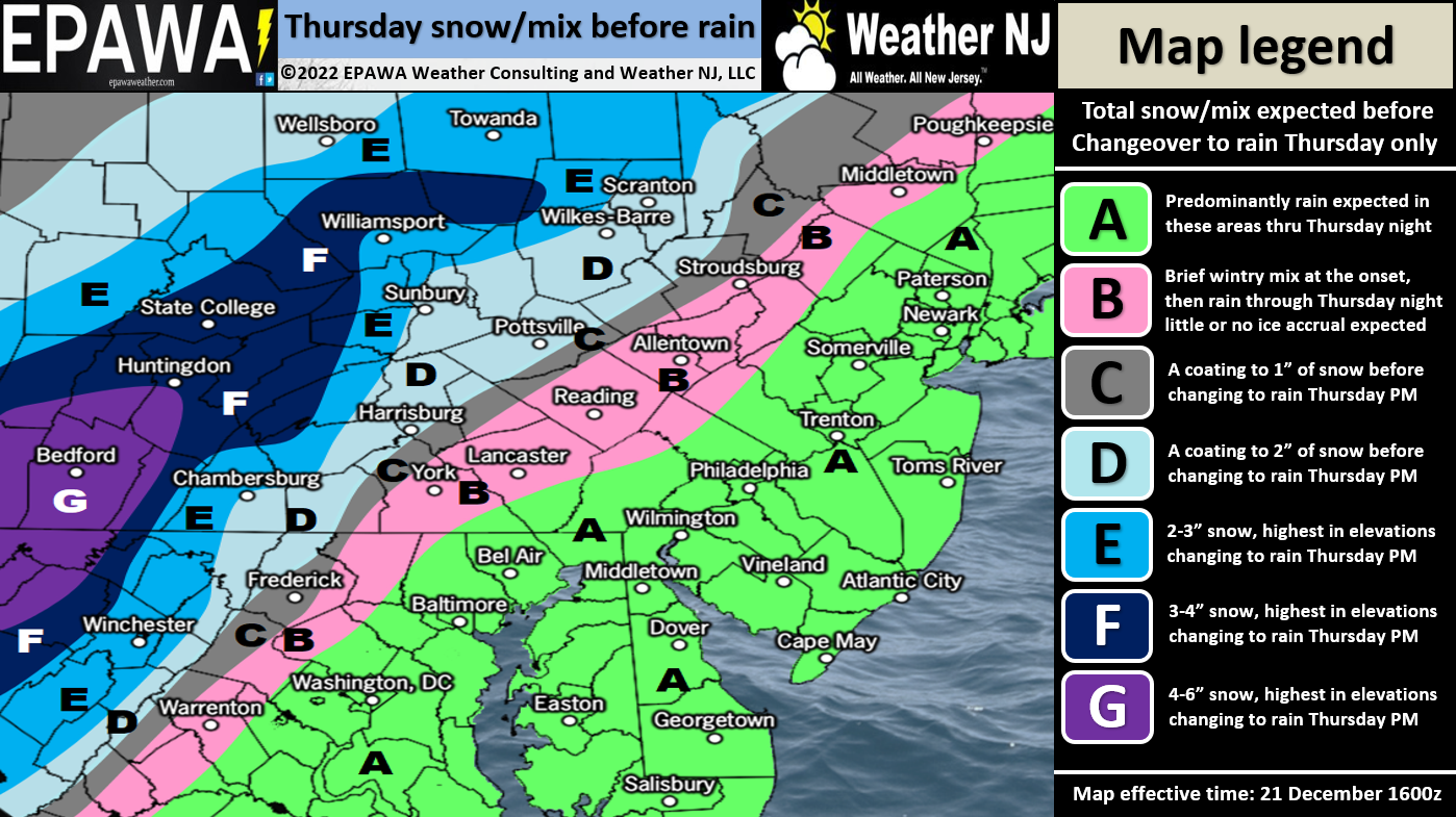
Precipitation: This will be mostly a rain event. Precipitation could start out on Tuesday wintry in the highest elevations of NWNJ but will still change to rain rather quickly. All of New Jersey should then expect about a half-inch to an inch and a half (.5 – 1.5) inches of rainfall Thursday PM into early Friday morning. We’re then looking at a lull on Friday morning. An area of subsidence (sinking air) will move over New Jersey and possibly allow some drying clearing. This is good for reasons I will cover in a bit. Precipitation should then move back in by Friday afternoon with the Arctic frontal passage. The Arctic front will likely change rain to snow sometime in the Friday afternoon-evening time frame. We’re not looking at a lot of snow. Mainly flakes to a dusting for SNJ and a coating to an inch or two for NNJ. Conversational snowfall. The following map only covers Thursday’s initial wintry possibilities and Thursday night-Friday morning rainfall. Tomorrow, we’ll dive into Friday’s Arctic front more regarding any expected accumulations:
Wind: This is the primary hazard. Winds will initially be out of the E (off the ocean) on Thursday. Between Thursday evening and Friday morning, wind will shift to the S with gusts generally ranging from 25-40mph. When the Arctic front moves through, winds will then switch from S to W and increase with gusts ranging from 35-50mph. It will then stay this way Friday PM through most of Saturday as the Arctic air mass continues to move in. throughout the entire storm timing (Thursday PM-Friday PM, maybe into Saturday), I would expect widespread wind-related power outages.
Temperature: This system is going to be a roller coaster of temperatures. We’re just coming off a colder but not brutal period (today is the last day of that). Tomorrow (Thursday), temperatures will begin warming ahead of the approaching rain (maybe snow for NWNJ). We’ll probably see widespread 40s to near-50 Thursday. Temperatures will then continue to rise Thursday night into Friday morning as the warmer onshore fetch flexes and winds become more S/SE then E. Friday could then feel abnormally warm with widespread temperatures likely flirting with 60, especially CNJ/SENJ. Then the Arctic front will come through and drop us from near-60 to teens in about a 12 hour period. That’s a 40-degree drop over 12 hours. Saturday morning will feel like a different planet of cold. The most critical temp drop is along the Arctic front when rain will change to ending snow.
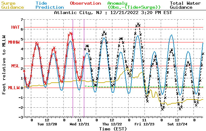
Coastal Flooding: Costal regions along the Jersey Shore and Delaware Bay should see minor, possibly localized moderate, levels of coastal flooding mainly associated with the onshore fetch off the ocean between Thursday night and Friday noon. The highest tide should be just before noon on Friday for those along the water in said areas. Luckily the strongest surge period (gold) occurs during low tide around midnight Thursday night. This Atlantic City tidal guidance shows it best:
In English: Expect a milder Thursday with rain likely moving in by afternoon (could start wintry for NWNJ elevations before quickly changing to rain (see map above)). Expect rain to then fall, heavy at times, Thursday night into early Friday morning. Expect a very mild Friday morning into early afternoon with a break in the rain/clearing during such time. Rain then returns by afternoon and likely changes to ending snowfall around late-Friday afternoon (near sunset). Behind that, expect a much colder air mass to take us down into the teens statewide (maybe single digits for elevations) by early Saturday morning. Winds should be breezy/gusty out of the S ahead of the Arctic Front (Thurs-PM to Friday AM) then gusty out of the W behind the front (Friday afternoon-forward). I’ll check back tomorrow with a final forecast update prior to the start of the storm. Chicago and the Great Lakes are in for a historic winter storm. We’re on the warm side of it. Have a great rest of your Wednesday and please be safe! JC
Premium Services
KABOOM Club offers inside info forecast discussion, your questions answered, and early storm impact maps (ahead of the public). At 99 cents per month, it’s an extremely feasible way to show support.
My Pocket Meteorologist (MPM), in partnership with EPAWA Weather Consulting, offers professional/commercial interests, whose businesses depend on outdoor weather conditions (snow plowing, landscaping, construction, etc.), with hyper-local text message alerts/forecasts and access to the MPM premium forum—the most comprehensive and technical forecast discussion available for PA and NJ.
Jonathan Carr (JC) is the founder and sole operator of Weather NJ, New Jersey’s largest independent weather reporting agency. Since 2010, Jonathan has provided weather safety discussion and forecasting services for New Jersey and surrounding areas through the web and social media. Originally branded as Severe NJ Weather (before 2014), Weather NJ is proud to bring you accurate and responsible forecast discussion ahead of high-stakes weather scenarios that impact this great garden state of ours. All Weather. All New Jersey.™ Be safe! JC


LOCAL FORECAST | INTERACTIVE RADAR | LATEST NJ WEATHER ALERTS | WEDDING FORECAST| PRIVACY POLICY
© Copyright 2026 Weather NJ LLC. All Rights Reserved.
Some information that can be found on our website is provided by a private weather station and is not an officially recognized station for weather reporting. Though we always strive to achieve accurate reporting for our own use, it is important that you do NOT depend on the data provided here for any purpose.
