

Strong Storm Detected for Thurs-Fri
Discussion: The expected storm system for this Thursday-Friday might not satisfy the snow lover with deep accumulations. But there are some powerful dynamics involved which could still produce hazardous conditions for holiday travel. Again, we’re chilly but not too cold through Wednesday. On Thursday we should warm up ahead of the following broken down impacts for Thursday-Friday:
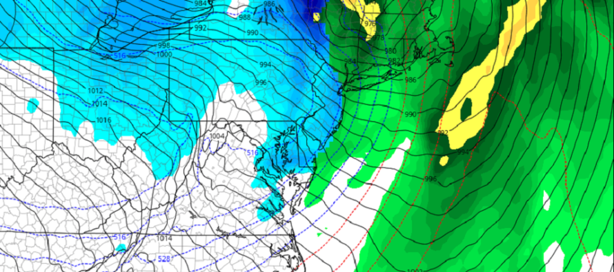
Rain: Precipitation should move in from the S on Thursday afternoon. It should then rain statewide on-and-off, heavy at times, through about Friday afternoon. A small break/lull in the rain is possible Friday morning before precipitation re-saturates along and ahead of the Arctic front. Rain should come to a conclusion with the passage of the Arctic front.
Wind: There are three main wind components. First is Thursday into Friday when winds will be out of the S/SW (ahead of the Arctic front). These winds should be 20-30mph with gusts to 40mph possible. SENJ/SWNJ would likely take the hardest S winds off the water (either Delaware Bay or Atlantic Ocean depending on which side of Cape May you are on). Then there will be the mesoscale winds associated with the Arctic front itself Friday afternoon/evening. These could be in any direction and would be mostly gust front-driven that could gust to 40mph at times. Lastly would be the winds behind the Arctic front (the really cold stuff). These will be out of the W or W/NW and could also gust over 40mph at times. These would be from Friday night into and likely through most of Saturday.
Coastal Flooding: The orientation is not horrible for coastal flooding. The S/SW winds will run parallel to the Jersey shore and the W/NW winds will push the ocean away from the Jersey Shore. The highest water levels should occur Thursday night into Friday as S/SW flow rips into the extreme SWNJ/SENJ coasts. Said areas could realize minor coastal flooding at that time. Otherwise, we’re not looking at a major coastal flooding event IMO.
Snow: Initial precipitation Thursday afternoon could begin wintry for the highest elevations of NWNJ but mostly for NEPA/CPA. I wouldn’t expect much from this other than a quick changeover to rain. Snow is then possible Friday PM as the Arctic front rips through the remaining precipitation from W to E. Anything from a coating to a few inches of snow accumulation are possible. Will have more detail on this as we closer approach.
Flash Freeze: This is the unique component that could present the most dangerous hazards. The Arctic front will push through the rain between Friday afternoon and evening. This will change rain to snow for all areas and freeze any freestanding water or roadways still wet. We’re looking at a 20-30 degree drop in temperature with the frontal passage. This will not a standard Canadian source cold front. This will be a piece of the Tropospheric Polar Vortex (TPV) being pulled down by a 1050mb+ high in the NWUS and the bombing low over the lakes (sub-980). This is also why such high winds are expected. That air mass will be pulled down behind the low and then eastward into New Jersey. The rainfall will erode any road treatments prior to the changeover so please consider how dangerously icy it could be come late-Friday night into Saturday morning.
The next signal to watch after this is a coastal system in the Dec 30 period. Other than that we should moderate milder to start 2023 before turning colder again in the second week or so of January.
In English: Chilly but not cold-cold through Wednesday. Temps then warm up a bit (above freezing for all) and rain moves in for Thursday afternoon through Friday afternoon. Winds should crank out of the S during the rainfall. Rain should then turn to snow Friday evening as the Arctic cold front moves through before precipitation ends. Winds should then stay high but switch to the W/NW behind the front (Friday evening-forward). The winds throughout this entire event are capable of generating power outages, mostly from downed branches/etc. The snowfall along the front could be an intense but short burst. It looks like anything from a coating to a few inches could fall for most areas and stick around for Christmas. Either way, get ready for a cold Christmas Eve-Day. There just might be some white around for it after all. Have a great rest of your Monday and please be safe! JC
Premium Services
KABOOM Club offers inside info forecast discussion, your questions answered, and early storm impact maps (ahead of the public). At 99 cents per month, it’s an extremely feasible way to show support.
My Pocket Meteorologist (MPM), in partnership with EPAWA Weather Consulting, offers professional/commercial interests, whose businesses depend on outdoor weather conditions (snow plowing, landscaping, construction, etc.), with hyper-local text message alerts/forecasts and access to the MPM premium forum—the most comprehensive and technical forecast discussion available for PA and NJ.
Jonathan Carr (JC) is the founder and sole operator of Weather NJ, New Jersey’s largest independent weather reporting agency. Since 2010, Jonathan has provided weather safety discussion and forecasting services for New Jersey and surrounding areas through the web and social media. Originally branded as Severe NJ Weather (before 2014), Weather NJ is proud to bring you accurate and responsible forecast discussion ahead of high-stakes weather scenarios that impact this great garden state of ours. All Weather. All New Jersey.™ Be safe! JC


LOCAL FORECAST | INTERACTIVE RADAR | LATEST NJ WEATHER ALERTS | WEDDING FORECAST| PRIVACY POLICY
© Copyright 2026 Weather NJ LLC. All Rights Reserved.
Some information that can be found on our website is provided by a private weather station and is not an officially recognized station for weather reporting. Though we always strive to achieve accurate reporting for our own use, it is important that you do NOT depend on the data provided here for any purpose.
