

Strong Storm to Impact New Jersey
Discussion: A strong coastal low will be just offshore tomorrow (Friday). While nearly all model guidance suggests the precip to stay about 20-50 miles offshore, I just want to mention a small wildcard possibility of those precip bands making it further W into NJ. The low might be sub-980mb which could easily make this happen. Surface temps will still be above freezing but heavier precipitation would, in theory, cool the surface. Again most likely it’s a complete miss. But wouldn’t be surprised to see at least flurries move off the ocean in far ECNJ/SENJ. Areas that normally see water in the streets (ECNJ and SENJ) will probably see water in the streets Friday night into Saturday morning. After all, it’s a powerful storm out there and will be pushing some water towards us.
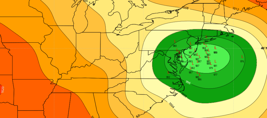
Sunday night into Monday (Jan 16-17) is a very complex and challenging forecast for New Jersey. It’s anything but a smooth single-vort storm system riding a stationary boundary. Instead we have multiple upper-level players on the field. We have the departing low (tomorrow’s miss), the primary upper-level low, and the trailing/steering “kicker” short wave. Each have influence over the surface low track in some way and each are in a sea of liquid chaos theory. With that said I still see a wide range of possibilities for Sunday night into Monday. The above photo (from GFS ensembles) represents the storm track possibilities (individual locations where the center of the storm could be Monday morning). Again, tremendous uncertainty from a very volatile setup.
I think the coldest possible solution (the furthest E) is a track just offshore of NJ, maybe 25-75 miles off the coast. In this case I still think areas S and E of the turnpike at least mix with ice/rain but it would mostly be a turnpike and NW significant-to-major snow storm. I think the warmest possible solution (the furthest W) is a track along the turnpike. This would roast all of NJ (all areas eventually over to rain). NWNJ would see the most snow of NJ before the changeover. All lower NJ elevations would change over almost immediately without wintry accumulation. This would produce a major winter storm for most of PA, NY State, interior New England. I honestly cannot narrow that possibility down any further at the current moment. The final piece of energy will be over land (better sampled) by tomorrow and that will likely provide the models with a better idea.
I am gaining confidence, however, in the probability for high winds and coastal flooding. First, we’re going to have a full moon on Monday which will provide already-higher astronomical tides. We’ll then likely have a period of strong onshore flow (Sunday night into Monday morning) capable of producing wind-driven storm surge. Add heavy rainfall to the coastal regions and that’s a triple threat. High tides vary by location but any that fall in the Sunday PM-Monday AM 24-period should be monitored for ECNJ/SENJ coastal flooding interests. I imagine the Delaware Bay coasts of SWNJ would be subject as well to a lesser extent than the ocean facing coasts. I am also thinking power outages are likely with the higher winds. Regardless of rain vs snow, it’s going to be windy statewide with coastal flooding issues likely.
Tomorrow I hope to have more confidence in anticipated precipitation type. Today’s guidance has come a little east meaning colder for more of NJ to the NW of the turnpike…still over to ice/rain for SENJ. There are going to be more trends uncovered especially once the final piece of energy is over N American land (tomorrow morning). Let’s see what another 24 hours of data and observations suggest. We are still 72-84 hours away. The pattern beyond Sunday-Monday continues to look active and favorable for winter storm development.
In English: Expect another relatively mild Friday tomorrow with temps reaching into the 40s. Winds will pick up out of the N/NW from the coastal storm just to our E and make for a cold Friday night (lows into teens/20s for most). Saturday looks frigid with highs ranging teens to 20s (N to S) followed by single digits and teens overnight into Sunday morning. Sunday should stay below freezing for most areas except the immediate SENJ coast where low-40s are possible from marine influence. We then turn all attention to the strong synoptic storm signal Sunday night into Monday. As of now I am becoming confident in high winds (strong storm) and coastal flooding (full moon). I still have tremendous uncertainty as to snow vs. rain for NJ. Need more time before generating snow maps. NWNJ would have the best chance for snow and SENJ would have the worst. We at least know that much. But whether it’s rain, ice, or snow, it’s going to be heavy and likely with high winds. Coastal regions of ECNJ/SENJ should have a plan in place for possible moderate-to-major flooding levels during the high tides between Sunday PM and Monday AM. See you tomorrow afternoon after 24 more hours of fresh data and observations. Be safe! JC
Download the free Weather NJ mobile app on Apple or Android. It’s the easiest way to never miss Weather NJ content. Our premium services go even further above and beyond at the hyper-local level.
Jonathan Carr (JC) is the founder and sole operator of Weather NJ, New Jersey’s largest independent weather reporting agency. Since 2010, Jonathan has provided weather safety discussion and forecasting services for New Jersey and surrounding areas through the web and social media. Originally branded as Severe NJ Weather (before 2014), Weather NJ is proud to bring you accurate and responsible forecast discussion ahead of high-stakes weather scenarios that impact this great garden state of ours. All Weather. All New Jersey.™ Be safe! JC


LOCAL FORECAST | INTERACTIVE RADAR | LATEST NJ WEATHER ALERTS | WEDDING FORECAST| PRIVACY POLICY
© Copyright 2026 Weather NJ LLC. All Rights Reserved.
Some information that can be found on our website is provided by a private weather station and is not an officially recognized station for weather reporting. Though we always strive to achieve accurate reporting for our own use, it is important that you do NOT depend on the data provided here for any purpose.
