

Summery Weekend Starts with a Bang
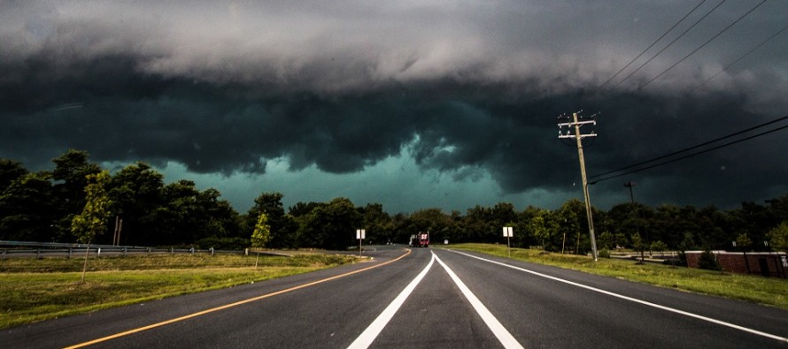
Discussion: Thunderstorms associated with a Mesoscale Convective Vortex (MCV) are approaching NJ from the W. NENJ and ECNJ look a bit more stable but NWNJ and most of SNJ are baking in instability today. The NWS has a tornado watch up due to the cyclonic shear dynamics that a MCV brings, especially when plowing into the unstable storm fuel. At the very least, everyone should be ready for wind gusts possible to 70mph with more common wind gusts in the 45-60mph range. Lightning should be frequent, and hail could be large. The rest of the weekend is then spent in a warm sector of above-average temperatures and higher humidity. it looks clear though with a likely capping inversion inhibiting most pop-up storm potential. Super isolated if not. A cold front should then cool it off Sunday night-into Monday for a cooler week next week.
In English: Expect a rocky next couple of hours in NJ from W to E as thunderstorms push through capable of heavy downpours and damaging winds (most likely), large hail (lesser likely but good shot), and isolated tornadoes (least likely but decent chance). SWNJ is most favored. NENJ is least favored for storm impact. Everyone between has a solid chance. This is approaching WNJ now and should clear ENJ by 6pm if not earlier.
Weekend Forecast:
Friday (May 20) high temperatures are currently maxing in SWNJ in the 80s (nearing-90) but E Monmouth up into NNJ is in the 60s/70s. Severe thunderstorms are likely between late afternoon and early evening (see above discussion). Temps should cool down into the 60s overnight with a muggy feel.
Saturday (May 21) high temperatures should reach into the 90s for most areas. Maybe lower-80s for immediate ECNJ/SENJ coastal locations. Humidity will make for higher heat indices. Skies should be mostly sunny with maybe some sea breeze cloud action for ECNJ/SENJ. Winds should be light out of the SW. Overnight lows should only dip to about 70 for most.
Sunday (May 22) high temperatures should reach into the 90s again (80s for coasties). Skies should be mixed with sun and clouds during the day with shower and thunderstorms possible later during PM hours. Winds should remain light out of the SW. Overnight lows should fall into the 50s/60s.
An early look at next week indicates moderation back into highs of 70s (some 60s). Unsettled conditions throughout the week. Still to early for a Memorial Day Weekend forecast but it looks like there won’t be hurricane remnants to deal with. I’ll take a solid stab at it on Sunday. Have a great weekend and please be safe! JC
Premium Services
KABOOM Club offers inside info forecast discussion, your questions answered, and early storm impact maps (ahead of the public). At a buck per month, it’s an extremely feasible way to show support.
My Pocket Meteorologist (MPM), in partnership with EPAWA Weather Consulting, offers professional/commercial interests, whose businesses depend on outdoor weather conditions (snow plowing, landscaping, construction, etc.), with hyper-local text message alerts/forecasts and access to the MPM premium forum—the most comprehensive and technical forecast discussion available for PA and NJ.
Jonathan Carr (JC) is the founder and sole operator of Weather NJ, New Jersey’s largest independent weather reporting agency. Since 2010, Jonathan has provided weather safety discussion and forecasting services for New Jersey and surrounding areas through the web and social media. Originally branded as Severe NJ Weather (before 2014), Weather NJ is proud to bring you accurate and responsible forecast discussion ahead of high-stakes weather scenarios that impact this great garden state of ours. All Weather. All New Jersey.™ Be safe! JC


LOCAL FORECAST | INTERACTIVE RADAR | LATEST NJ WEATHER ALERTS | WEDDING FORECAST| PRIVACY POLICY
© Copyright 2026 Weather NJ LLC. All Rights Reserved.
Some information that can be found on our website is provided by a private weather station and is not an officially recognized station for weather reporting. Though we always strive to achieve accurate reporting for our own use, it is important that you do NOT depend on the data provided here for any purpose.
