

Sun-Mon NJ Snowstorm Remains Uncertain
Discussion: Some of the latest model guidance starts this snowstorm as early as 6-7am Sunday morning. That puts NJ potentially a little over 60 hours away from first flakes. The problem is that we still have a significant amount of disagreement in the data and we’re not yet close enough to have full sampling with all energy over land. We’re close but won’t be there until we’re through the 12z model suite tomorrow (Friday). Therefore, today and tonight makes up the final period we can use for “storm vs. no storm” decision analysis. Tomorrow, if there’s still support for a snowstorm, we will have to issue a first call snow map and forecast for the potential this coming Sunday-Monday.
Our primary focal point of the upper levels for the past few days has been whether or not the energy from Friday’s rain system can eject and escape away from the approaching Sunday-Monday storm energy. In the cases where the leading Friday rain energy lingered back, it joined up with the approaching Sunday-Monday energy and forced a strung-out progressive coastal low that tracks too far E out to sea to cause the coastal NJ snowstorm. In cases where the Friday rain energy separated from the approaching Sunday-Monday storm energy (with a small height build between), this allowed the Sunday-Monday storm system to breathe and develop properly. We’ve moved beyond this point now as every model now sees separation, even the Euro.
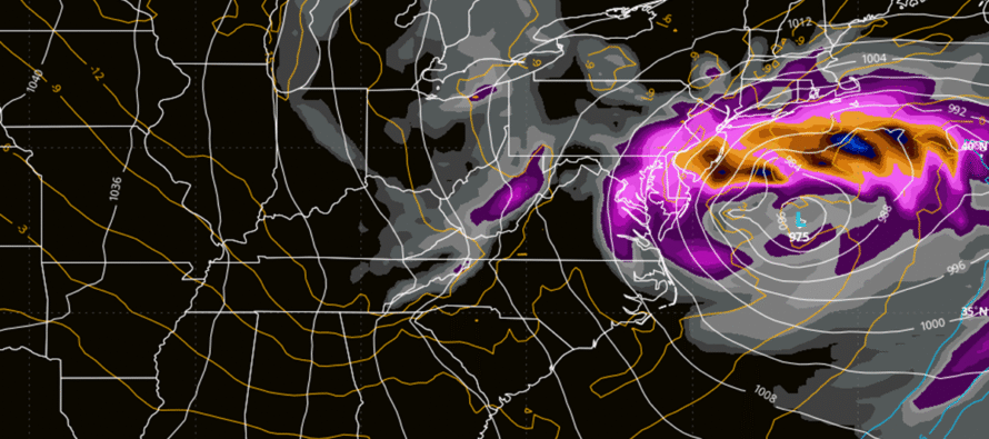
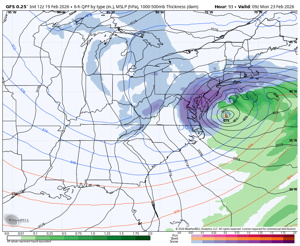
What we’re now looking closely at is the upper-level interaction between the sub-components of the Sunday-Monday storm energy, specifically what it does Friday-Saturday when moving from W US into the C US. We have a polar wave of energy that’s already over land in SW Canada. Then we have a Pacific wave of energy that should be onshore over N California tonight. For the major snowstorm to happen, the polar wave must phase into the Pacific wave in enough time to form a larger singular pocket of cyclonic vorticity to form a closed-off upper low. It must do this in enough time to throw a lasso around the coastal surface low that will be forming off OBX. The coastal surface low will be deepening in strength over time. If this low is lassoed back to the NW (towards NJ) before being allowed to eventually escape to the NW, then it deepens much closer to NJ and we get the historical KABOOM. This is what the GFS is suggesting (see below).
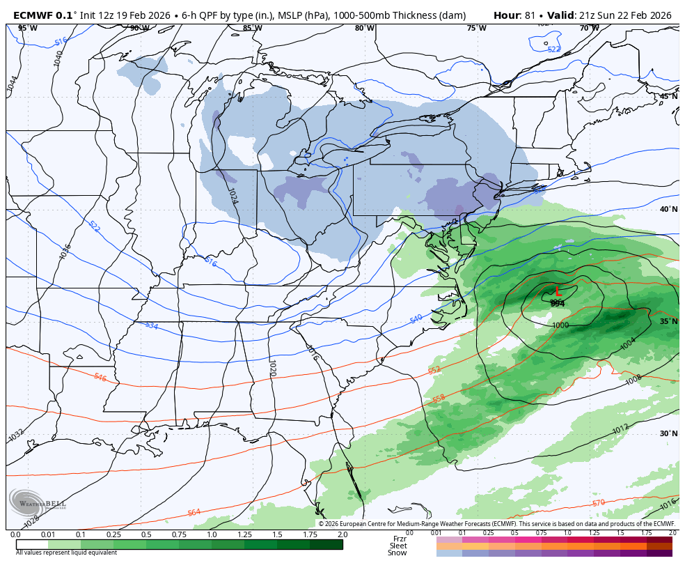
If the polar wave misses the Pacific wave with the lasso, then the Pacific energy simply shoots out to the E (progressive flow) and takes the coastal low out to sea with it. In that case, the polar low will still move across the region and drop a light-to-moderate snow event across some of New Jersey (Likely NW of 95). This is more what the Euro is suggesting (see below).
The rest of the models are somewhere between, some misses but some still with heavier snow for parts of NJ.
I know many are concerned about timing but please realize we’re in the final stages of storm vs. no storm decision analysis. The result of that could mean the different between all hours of Sunday-Monday to maybe just a 6–12-hour period of lighter snow. But in any case, the impacts are between Sunday and Monday and that’s about as much as we can narrow it down to at this point.
We need to see how the timing of the Pacific and polar shortwaves evolves over the next 24 hours before deciding the caliber of snowfall to expect. Tomorrow, we will then issue snow maps accordingly upon review of the 12Z model suite. That will give us 18z, 00z, 06z and 12z tomorrow. This is the point where you say “huge model runs tonight!” I’ll have a video out tonight similar to this article and covering any 18z model suite developments.
In English: If everything were to come together in perfect phase timing then NJ would see a historical KABOOM snowstorm this Sunday-Monday, as models like the GFS shows (image above on cover). If things don’t quite come together on time, then NJ is looking at much lighter snow possibilities, much like what the Euro shows (image above). It’s a 50/50 chance either way IMO. This is the last day of storm vs. no storm decision analysis. Model runs tonight through tomorrow afternoon will formulate our decision tomorrow on snowfall intensity expectations (snowstorm vs snow showers) this Sunday-Monday. Timing will also be addressed tomorrow within a smaller and more realistic window than just “Sunday-Monday.” If the GFS is right though, snowfall could begin as early as 6am Sunday morning and taper off as late as Monday night. If the Euro is right, then we’re looking at a much smaller window of snowfall potential within that Sunday-Monday overall period. Please note that a GFS-like solution would come with high winds and coastal flooding potential. The Euro-like solution would be much kinder on winds and coasts. I’ll see you later tonight in my YouTube video. Be safe! JC
Premium Services
KABOOM Club offers an ad-free environment, inside info (Above and Beyond) forecast discussion, your questions prioritized, and early storm impact maps and video releases (ahead of the public). At $1.99 per month, it’s an extremely feasible way to show additional support for Weather NJ and you can turn it on and off for however many months you wish. Think of it as a tip jar with perks. Available onFacebook or Patreon.
My Pocket Meteorologist (MPM), in partnership with EPAWA Weather Consulting, offers professional/commercial interests, whose businesses depend on outdoor weather conditions (snow plowing, landscaping, construction, etc.), with hyper-local text message alerts/forecasts from real meteorologists and access to the MPM premium forum—the most comprehensive and technical forecast discussion available for PA and NJ commercial interests.
KABOOM Shop is live if you want some KABOOM or Weather NJ Merch!
Sign up for ZoneWatch Radar and get 10% off
Jonathan Carr (JC) is the founder and sole operator of Weather NJ, New Jersey’s largest independent weather reporting agency. Since 2010, Jonathan has provided weather safety discussion and forecasting services for New Jersey and surrounding areas through the web and social media. Originally branded as Severe NJ Weather (before 2014), Weather NJ is proud to bring you accurate and responsible forecast discussion ahead of high-stakes weather scenarios that impact this great garden state of ours. All Weather. All New Jersey.™ Be safe! JC


LOCAL FORECAST | INTERACTIVE RADAR | LATEST NJ WEATHER ALERTS | WEDDING FORECAST| PRIVACY POLICY
© Copyright 2026 Weather NJ LLC. All Rights Reserved.
Some information that can be found on our website is provided by a private weather station and is not an officially recognized station for weather reporting. Though we always strive to achieve accurate reporting for our own use, it is important that you do NOT depend on the data provided here for any purpose.
