

Sunday Night Snow a GO
Discussion: This snow potential Sunday night into early Monday morning has been beat to death for the past week+ here and especially in KABOOM Club. We identified this period as a storm signal early and have been walking it in responsibly since. Saw some click-bait sites post 12-inch+ snow maps earlier this week. Saw a few other outlets and pros get juked out to the point of prematurely dismissing the possibility completely. It was never taken off the table here and instead has been included in a range of possibilities. The range we’ve been suggesting is anything from rain in SNJ only to a statewide 2-4/3-6 heavy wet snowfall with reality falling somewhere in the middle of that spread. As we sit here today only a little over 24 hours away from the beginning of the system, it’s leaning more towards the latter solution but not quite 2-4/3-6. Not a big deal but mildly disruptive with a few standard safety hazards (slushy slick roads, etc.).
This will be a very marginal temperature environment. Daytime temperatures are going to push well into the 40s on Sunday, even close to 50 for SNJ/SENJ. When initial precipitation arrives from the SW, it will be from the southern stream energy only with it’s own built-in warmth. It won’t be until the northern stream energy digs in from the N, that temperatures drop at all levels to support snowfall and snow accumulation. So, we’re likely looking at a rainy start Sunday afternoon with a snow/rain line that forms somewhere near I-95 and then advances southward through the event, turning areas that started as rain to snow to the SE of I-95. It’s a quick mover so should be out of here shortly after midnight Sunday night. The most wintry aspect of this system should occur between about 7pm and 2am Sunday night into Monday morning. The sun will be down and the northern stream will inject and mix cold throughout the system. So, we do have the advantage of overnight snowfall to counter an otherwise marginal situation, but its still going to be close to freezing, not well below like prior systems this winter. This is a thread the needle occurrence overnight in an otherwise reloading milder pattern. If it weren’t for the existing snowpack leftover from the Jan 25 snowstorm, nighttime surface temps would be milder like the daytime temps currently occurring.
For this snow event, we are looking at snow ratios between 8:1 and 10:1 which will produce a very wet, cement-like, snow accumulation. If slushy dustings isn’t a band name, it should be. This is the kind of snowstorm where 3-6 can fall out of the sky, 2-4 sticks to natural surfaces and then only 1-2 sticks to the roads. So the surface type will matter where you measure.
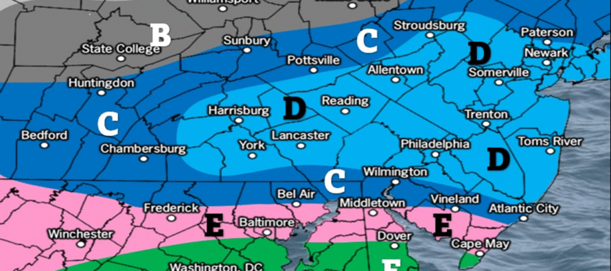
With all of that said, here’s our first call snow map for tomorrow afternoon/evening into early Monday morning. We’ll have one more chance tomorrow to refine this before live observations begin sometime between tomorrow afternoon and evening.
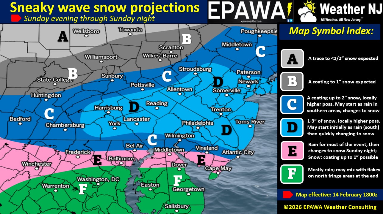
In English: We’re currently experiencing milder days but still colder nights (thanks to snow pack assist). Tomorrow (Sunday) temps will max well above freezing but then crash to freezing or just below after sunset. Precipitation will move into SNJ between tomorrow afternoon and evening, likely as rain first. Snow should then break out for NNJ/CNJ and slowly change from rain to snow for SNJ as a wet snowfall picks up in intensity from about 7pm into later Sunday night/just after midnight. All precipitation should taper off and end by 2-3am Monday morning. Extreme SNJ/SENJ should take the biggest snow accumulation reduction from surface temps and the most amount of rain. The jackpot is still yet TBD but should fall somewhere on our D zone of the above map. Expect that to tighten some for tomorrow’s map revision. Tomorrow we will also adjust amounts accordingly. Please note that we have the language “locally higher possible” in our jackpot ranges to account for some of the more aggressive recent trending model guidance. However, even in the coldest performance possible, I doubt this would produce more than a 2-4/3-6 situation. The marginal temperature environment and progressive quick-moving timing limits that upside maximum potential. On the other hand we are as low as one inch on the bottom of our jackpot ranges. The good news is that right after this, we head into our warmup next week which will melt most of this as well as any remaining snow pack from the Jan 25 system. I’ll try to get a video out tonight to better visualize some of the dynamics involved. But it might be later as I’m cooking a very special meal for my two favorite Valentines (Mrs. JC and Sophie). Have a great rest of your Saturday and please be safe! JC
Premium Services
KABOOM Club offers an ad-free environment, inside info (Above and Beyond) forecast discussion, your questions prioritized, and early storm impact maps and video releases (ahead of the public). At $1.99 per month, it’s an extremely feasible way to show additional support for Weather NJ and you can turn it on and off for however many months you wish. Think of it as a tip jar with perks. Available onFacebook or Patreon.
My Pocket Meteorologist (MPM), in partnership with EPAWA Weather Consulting, offers professional/commercial interests, whose businesses depend on outdoor weather conditions (snow plowing, landscaping, construction, etc.), with hyper-local text message alerts/forecasts from real meteorologists and access to the MPM premium forum—the most comprehensive and technical forecast discussion available for PA and NJ commercial interests.
KABOOM Shop is live if you want some KABOOM or Weather NJ Merch!
Sign up for ZoneWatch Radar and get 10% off
Jonathan Carr (JC) is the founder and sole operator of Weather NJ, New Jersey’s largest independent weather reporting agency. Since 2010, Jonathan has provided weather safety discussion and forecasting services for New Jersey and surrounding areas through the web and social media. Originally branded as Severe NJ Weather (before 2014), Weather NJ is proud to bring you accurate and responsible forecast discussion ahead of high-stakes weather scenarios that impact this great garden state of ours. All Weather. All New Jersey.™ Be safe! JC


LOCAL FORECAST | INTERACTIVE RADAR | LATEST NJ WEATHER ALERTS | WEDDING FORECAST| PRIVACY POLICY
© Copyright 2026 Weather NJ LLC. All Rights Reserved.
Some information that can be found on our website is provided by a private weather station and is not an officially recognized station for weather reporting. Though we always strive to achieve accurate reporting for our own use, it is important that you do NOT depend on the data provided here for any purpose.
