

Sunday Snow Targeting SENJ
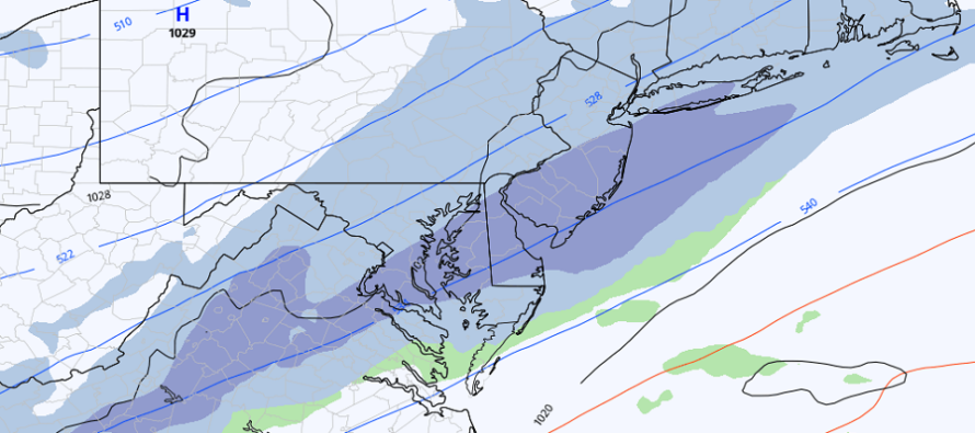
Discussion: We can’t write this late-weekend system off because it’s still bringing at least light snow to much of the state on most model guidance. The image above is a 6-hour shot of precip representing the furthest NW the system gets on the latest Euro.
Model guidance is converging on the idea of a very light event along and NW of I-95/NJTP. Anywhere from a coating to an inch or two seems like a realistic expectation. Areas SE of I-95/NJTP, especially the SENJ areas hardest hit by the Jan 28-29 snowstorm, should see slightly more. It’s still yet TBD if it will be more of a 1-3 or 3-6 type event. The former would keep this a light event overall. The latter could meet winter storm criteria for SENJ (Cumberland/Cape May/Atlantic/SE Burlington/S Ocean) and produce more of a significant/plowable snowfall. I think by tomorrow, we’ll have this ironed out more.
For now, the latest trends have been sooner and weaker. Most models start snow early Sunday morning and wrap it up by Sunday afternoon. This is no longer bleeding into any of Monday. The surface low remains modeled in the 1006-999mb range and upper-level steering currents remain progressively modeled off the front of a positive trough. It’s up to the cyclonic vorticity phasing to determine how much lifting can occur in such a progressive and weak storm development environment. There will be help by the upper jet but again, this has trended sooner and shorter in duration.
I don’t see much room for this to shift NW (to the NW of I-95/NJTP). I could however see expected snow amounts in SNJ/SENJ bounce around between now and Saturday night. We’re shooting for a first snow map tomorrow by 5pm. For now, a probabilities-based call would say C-2” NW of 95 (dropping to nothing by NWNJ) and 1-3 SE of 95, maybe 3-6 for SENJ.
No wind or coastal flooding issues to worry. All precipitation type should be snow for this with temperatures eventually dropping into the low-mid 20s for the second half of snowfall. The Saturday night through Monday period looks cold (surrounding the event) but we should then rebound to the milder feel by next Tuesday. In the meantime, enjoy the mild build up through Saturday afternoon/evening. Like I said yesterday, it will be hard to believe snow is possible on Sunday when it’s in the 50s and 60s on Saturday afternoon.
In English: Mild conditions should continue through Saturday afternoon. Temperatures should then drop Saturday night into Sunday as light snow likely approaches NJ from the SW and moves through by Sunday afternoon/evening. SENJ could see heavier snow and push into the plowable category of 3-6” but the rest of NJ looks like a C-2 (NW of 95) and 1-3” (just SE of 95). One more day of data analysis and then a forecast/map likely tomorrow at 5pm. It doesn’t look like a big deal at this point outside of SENJ. I’ll be monitoring closely for any changes. Have a great rest of your Thursday and please be safe! JC
Jonathan Carr (JC) is the founder and sole operator of Weather NJ, New Jersey’s largest independent weather reporting agency. Since 2010, Jonathan has provided weather safety discussion and forecasting services for New Jersey and surrounding areas through the web and social media. Originally branded as Severe NJ Weather (before 2014), Weather NJ is proud to bring you accurate and responsible forecast discussion ahead of high-stakes weather scenarios that impact this great garden state of ours. All Weather. All New Jersey.™ Be safe! JC


LOCAL FORECAST | INTERACTIVE RADAR | LATEST NJ WEATHER ALERTS | WEDDING FORECAST| PRIVACY POLICY
© Copyright 2026 Weather NJ LLC. All Rights Reserved.
Some information that can be found on our website is provided by a private weather station and is not an officially recognized station for weather reporting. Though we always strive to achieve accurate reporting for our own use, it is important that you do NOT depend on the data provided here for any purpose.
