

Sunday Snowstorm Approaching
Discussion: My previous live observation real covered the remainder of the Saturday morning wave. This article will now cover the Sunday-Monday coastal snowstorm. It’s still not a KABOOM, but it certainly is a coastal snowstorm capable of delivering a significant/plowable outcome for much of New Jersey. This morning and tomorrow are the fruition of the early-identified Jan 15-20 pattern favorable for supporting a snowstorm. Within that pattern were two signals, Jan 15-16 and Jan 18-19. The Jan 15-16 signal did not produce. The Jan 18-19 is about to.
So, the last thing I’ll mention about today is that the Arctic front was slower to push through NJ. It got hung up a little bit by forces behind that. That allowed today’s disturbance to have more time to ride the boundary over NJ and affect the areas most expecting snow. This plays into tomorrow (Sunday) because the slower boundary will not advance as far out to sea. The coastal low will then take a track closer to the E US coast Sunday into Monday allowing the colder snowy precipitation on its NW side to push in further off the ocean. The 6Z models picked up on this this morning and began the adjustment. The 12z models have followed suit and we expect the next last few model runs to continue to converge on a solution. The other area of interest is the coastal areas of ECNJ/SENJ. Surface temps are modeled to be in the 32-35 range. Snow rates however will likely bring colder air down and if this gets going earlier Sunday, it will set a colder surface temp profile. But with that said, the warmest hours of the day could allow anything from poor dendritic growth to mixing to maybe even plain rain at the immediate coast. Temps would then drop into Sunday evening and said areas would return to snow. That’s why we created the Zone F in our map. This zone could be inhibited by the warmer coastal concerns or it could be overridden in which case Zone F would be more like Zone E.
The timing has expanded left and right given the larger outcome potential. Right now, thinking first flakes fall as early as 7am Sunday and last flakes taper as late as 2am Monday. The meat and potatoes of it probably between noon and midnight on Sunday night. Here’s our snow map forecast for tomorrow:
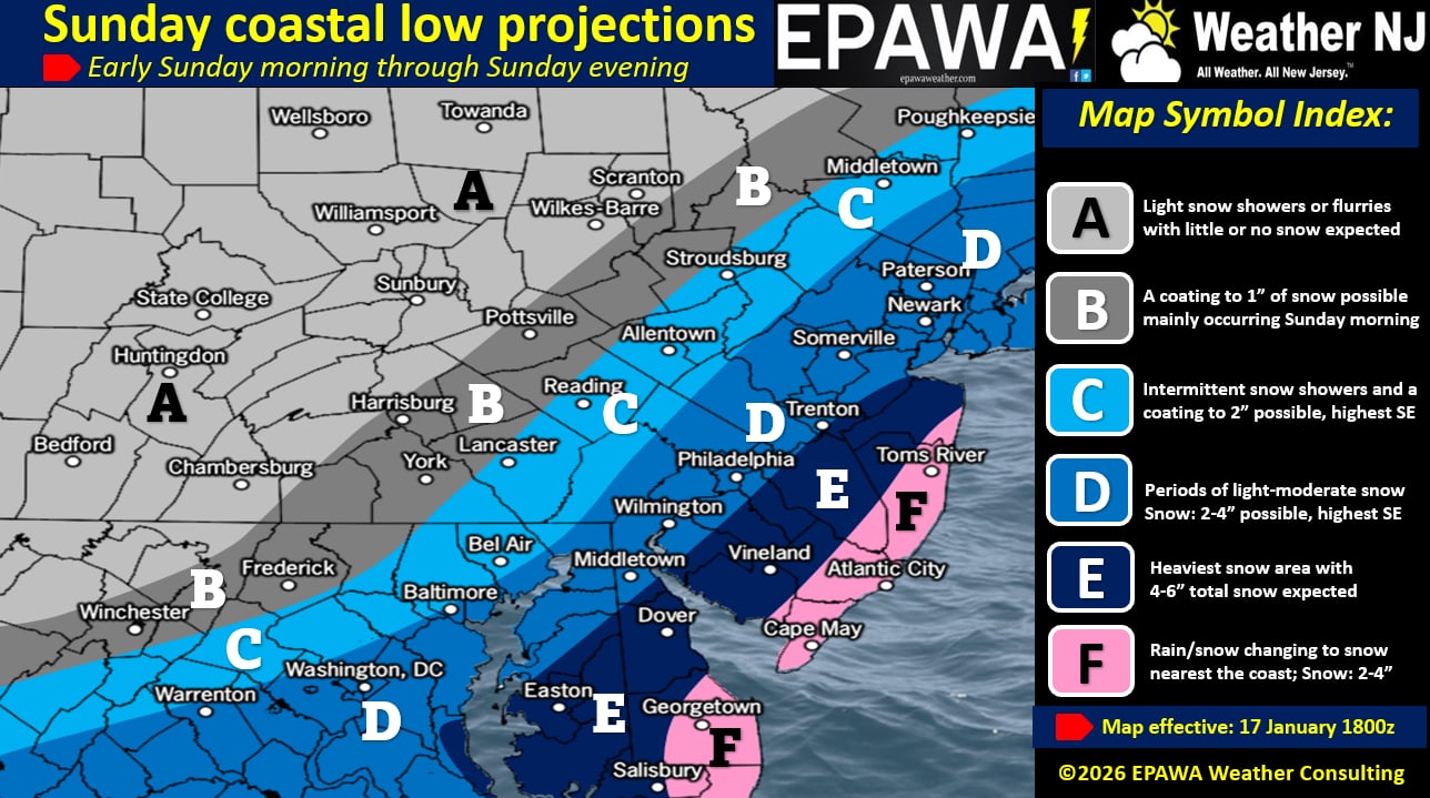
In English: It snowed this morning with accumulations realized in NNJ. It will snow and accumulate to a plowable situation for many in NJ. Our above map illustrates a conservative and reasonable expectation of what we’re thinking for amounts tomorrow. Zone F could go like Zone E Have a great rest of your Saturday and please be safe! JC
Premium Services
KABOOM Club offers an ad-free environment, inside info (Above and Beyond) forecast discussion, your questions prioritized, and early storm impact maps and video releases (ahead of the public). At $1.99 per month, it’s an extremely feasible way to show additional support for Weather NJ and you can turn it on and off for however many months you wish. Think of it as a tip jar with perks. Available onFacebook or Patreon.
My Pocket Meteorologist (MPM), in partnership with EPAWA Weather Consulting, offers professional/commercial interests, whose businesses depend on outdoor weather conditions (snow plowing, landscaping, construction, etc.), with hyper-local text message alerts/forecasts from real meteorologists and access to the MPM premium forum—the most comprehensive and technical forecast discussion available for PA and NJ commercial interests.
KABOOM Shop is live if you want some KABOOM or Weather NJ Merch!
Sign up for ZoneWatch Radar and get 10% off
Jonathan Carr (JC) is the founder and sole operator of Weather NJ, New Jersey’s largest independent weather reporting agency. Since 2010, Jonathan has provided weather safety discussion and forecasting services for New Jersey and surrounding areas through the web and social media. Originally branded as Severe NJ Weather (before 2014), Weather NJ is proud to bring you accurate and responsible forecast discussion ahead of high-stakes weather scenarios that impact this great garden state of ours. All Weather. All New Jersey.™ Be safe! JC


LOCAL FORECAST | INTERACTIVE RADAR | LATEST NJ WEATHER ALERTS | WEDDING FORECAST| PRIVACY POLICY
© Copyright 2026 Weather NJ LLC. All Rights Reserved.
Some information that can be found on our website is provided by a private weather station and is not an officially recognized station for weather reporting. Though we always strive to achieve accurate reporting for our own use, it is important that you do NOT depend on the data provided here for any purpose.
