

Talking Thunderstorms (Aug 13-16)
Discussion: We’re going to do the weekly outlook and Tuesday thunderstorm discussion in a single article. Today we saw elevated levels of humidity return after a pleasant weekend. And when I say pleasant I mostly mean the humidity. I realize it still popped into the 80s on Saturday and Sunday. But dry 80s and humid 80s are different planets of feelz especially overnight with temps dropping into the 50s for many locations.
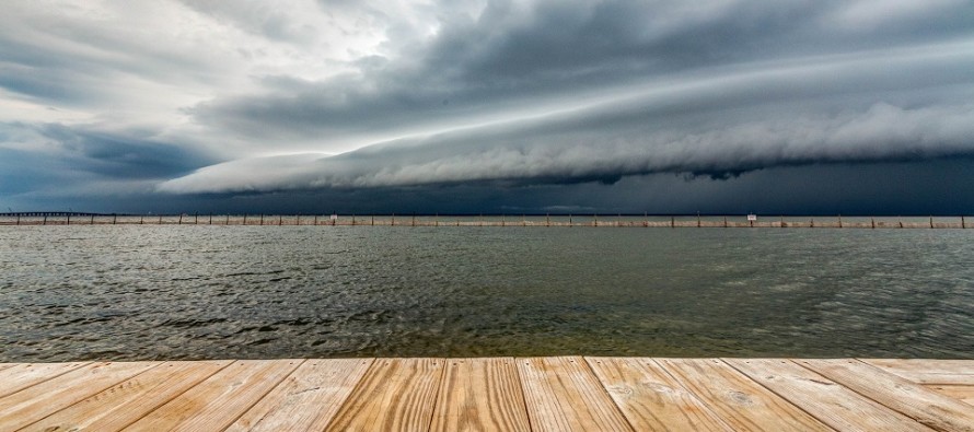
Tuesday presents a rather serious possibility of severe thunderstorms. The upper levels look rather flat and zonal. Therefore the upper-level jet could enhance storm development by allowing the storm cells to exhaust and breath. Geopotential height anomalies are near neutral to slightly below-average. This tells me that colder air aloft could do two things. One…allow for hail. Two…enhance destabilization by allowing the warmer surface air mass to rise more easily. I think this takes a capping inversion off the table completely. Also we have a few surface low centers moving through that will likely force intense lifting. With all of this said some very strong-to-severe thunderstorms are possible which are capable of producing both straight-line and tornadic damaging winds. Can’t take anything off the table for tomorrow. Additionally the cells are expected to move slowly and dump a lot of moisture. PWAT values will be high and therefore flash flooding is very likely. As far as timing let’s split NJ into NNJ and SNJ. NNJ showtime should be between 2pm and 7pm. SNJ showtime should be between 7pm and midnight possibly a bit into Wednesday AM. I’ll report accordingly tomorrow via radar/live observations.
The rest of the week looks fairly run-of-mill for August. Highs in the 80s, some humidity and typical pop-up showers and thunderstorms. This should also spill into the weekend. Let’s get through tomorrow first and then see where things stand in the wake of the outbreak.
Tuesday (Aug 13) high temperatures should range from the mid-70s to mid-80s. You might see the sun here and there but strong-to-severe thunderstorms are possible and should have the headline. Humidity should be felt ahead of the storms. Flash flooding and damaging winds are possible. Please see the discussion above. Winds should be light out of the S/SW. Overnight lows should range from mid-60s to lower-70s NNJ to SNJ.
Wednesday (Aug 14) high temperatures should range from mid-70s to mid-80s NNJ to SNJ. Skies should be mixed with sun and clouds. Lingering showers and thunderstorms are possible moreso for SNJ. Winds should be out of the N for the northern 2/3 of NJ. SNJ a little more out of the W. Overnight lows should range from near-60 to near-70 NNJ to SNJ.
Thursday (Aug 15) high temperatures should reach near-80 for most areas. Skies should be partly cloudy with a few showers and thunderstorms around. Winds should be light out of the SE. Overnight lows should range from near-60 to near-70 NNJ to SNJ.
Friday (Aug 16) high temperatures should reach the low-to-mid 80s for most areas. Skies should be partly cloudy and humid with a few showers and thunderstorms around. Winds should be light out of the E. Overnight lows should range from near-60 to near-70 NNJ to SNJ.
An early look at the weekend indicates more conditions like Friday. Highs in the 80s, humidity, stormy but not a washout. Let’s see how it looks in a few days. Have a great rest of your week and please be safe! JC
Download the new free Weather NJ mobile app on Apple and/or Android. It’s the easiest way to never miss Weather NJ content. Our premium services go even further above and beyond at the hyperlocal level. Looking for industrial-caliber long-range forecasting data that I personally recommend? Check out WeatherTrends360!
Jonathan Carr (JC) is the founder and sole operator of Weather NJ, New Jersey’s largest independent weather reporting agency. Since 2010, Jonathan has provided weather safety discussion and forecasting services for New Jersey and surrounding areas through the web and social media. Originally branded as Severe NJ Weather (before 2014), Weather NJ is proud to bring you accurate and responsible forecast discussion ahead of high-stakes weather scenarios that impact this great garden state of ours. All Weather. All New Jersey.™ Be safe! JC


LOCAL FORECAST | INTERACTIVE RADAR | LATEST NJ WEATHER ALERTS | WEDDING FORECAST| PRIVACY POLICY
© Copyright 2025 Weather NJ LLC. All Rights Reserved.
Some information that can be found on our website is provided by a private weather station and is not an officially recognized station for weather reporting. Though we always strive to achieve accurate reporting for our own use, it is important that you do NOT depend on the data provided here for any purpose.

)